Abulfeda (cràter)
 | Per a altres significats, vegeu «Abu-l-Fidà». |
 Abulfeda Abulfeda | |
|---|---|
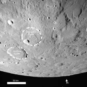 Els cràters Descartes i Abulfeda | |
| Dades generals | |
| Tipus | cràter d'impacte  |
| Cos astronòmic | Lluna |
| Epònim | Abu-l-Fidà |
| Dades geogràfiques | |
| Coordenades | 13° 52′ S, 13° 55′ E / 13.87°S,13.91°E / -13.87; 13.91 |
| Diàmetre | 62,2 km |
| Profunditat | 3.1 |
| Quadrangle | LQ20 |
| Colongitud | 346 ° al sol ixent |
| Localització | |
  | |
| Identificadors | |
| Gazetteer of Planetary Nomenclature | 23 |
Abulfeda és un cràter lunar a les terres altres centrals de la Lluna. Al nord-est hi ha el cràter Descartes i cap al sud sud-est el cràter Almanon. Una cadena de cràters anomenada Catena Abulfeda discorre entre el costat sud de l'Abulfeda i el costat nord de l'Almanon i continua al llarg de 210 kilòmetres a través de Rupes Altai.
Els costats sud i nord-est estan coberts per múltiples cràters petits. La paret interna és notablement ampla cap a l'est, i estreta i desgastada cap al nord. El terra del cràter ha sorgit per "ejecta" del Mare Imbrium o per lava basàltica, i és relativament llis i sense cap característica especial. Al cràter li falta una elevació central a la meitat, que potser va ser enterrada. Els costats interns apareixen una mica allisats; el més probable és que fos com a resultat d'un petit bombardeig o per sacsejades sísmiques d'altres impactes veïns.
Cràters satèl·lit
Per convenció, aquestes característiques s'identifiquen en els mapes lunars posant lletres al costat del punt central del cràter que hi ha més pròxim al cràter Abulfeda:
 |
|
Vegeu també
- Llista de cràters lunars
- Selenografia
Bibliografia
- (WGPSN), IAU Working Group for Planetary System Nomenclature. «Gazetteer of Planetary Nomenclature. 1:1 Million-Scale Maps of the Moon» (en anglès). UAI / USGS, 13-02-2013. [Consulta: 6 abril 2016].
- Andersson, L. E.; Whitaker, E. A.,. NASA Catalogue of Lunar Nomenclature (en anglès). NASA RP-1097, 1982.
- Blue, Jennifer. «Gazetteer of Planetary Nomenclature» (en anglès). USGS, 25-07-2007. [Consulta: 2 gener 2012].
- Bussey, B.; Spudis, P.. The Clementine Atlas of the Moon (en anglès). Nueva York: Cambridge University Press, 2004. ISBN 0-521-81528-2.
- Cocks, Elijah E.; Cocks, Josiah C.. Who's Who on the Moon: A Biographical Dictionary of Lunar Nomenclature (en anglès). Tudor Publishers, 1995. ISBN 0-936389-27-3.
- McDowell, Jonathan. «Lunar Nomenclature» (en anglès). Jonathan's Space Report, 15-07-2007. [Consulta: 2 gener 2012].
- Menzel, D. H.; Minnaert, M.; Levin, B.; Dollfus, A.; Bell, B. «Report on Lunar Nomenclature by The Working Group of Commission 17 of the IAU» (en anglès). Space Science Reviews, 12, 1971, pàg. 136.
- Moore, Patrick. On the Moon (en anglès). Sterling Publishing Co, 2001. ISBN 0-304-35469-4.
- Price, Fred W. The Moon Observer's Handbook (en anglès). Cambridge University Press, 1988. ISBN 0521335000.
- Rükl, Antonín. Atlas of the Moon (en anglès). Kalmbach Books, 1990. ISBN 0-913135-17-8.
- Webb, Rev. T. W.. Celestial Objects for Common Telescopes, 6ª edición revisada (en anglès). Dover, 1962. ISBN 0-486-20917-2.
- Whitaker, Ewen A. Mapping and Naming the Moon (en anglès). Cambridge University Press, 2003. 978-0-521-54414-6.
- Wlasuk, Peter T. Observing the Moon (en anglès). Springer, 2000. ISBN 1-85233-193-3.
Enllaços externs
- "Abulfeda (cràter)". Gazetteer of Planetary Nomenclature. USGS Astrogeology Research Program. (anglès)
- Localització del cràter Abulfeda
- McDowell, Jonathan. «Lunar Nomenclature» (en anglès). Jonathan's Space Report, 15-07-2007.
- «Digital Lunar Orbiter Photographic Atles of the Moon» (en anglès). [Consulta: 5 juliol 2018].
- «LROC :: QuickMap - Targeting Mapa LROC» (en anglès). [Consulta: 5 juliol 2018].