Ammuriya (Nablus)
 | Aquest article tracta sobre la vila de Cisjordània. Si cerqueu la vila de Jordània, vegeu «Ammuriya (Jordània)». |
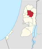
| Localització | ||||
|---|---|---|---|---|
| ||||
| Estat | Estat de Palestina | |||
| Territori ocupat | Cisjordània | |||
| Governacions | Governació de Nablus  | |||
| Geografia | ||||
| Altitud | 720 m | |||
| Limita amb | Salfit Khirbet Qeis (en) Al-Lubban ash-Sharqiya | |||
| Identificador descriptiu | ||||
| Fus horari | UTC+02:00 UTC+03:00 | |||

Ammuriya, també escrit 'Amuria[1] (àrab: عمورية, ʿAmmūriyya) és un vila palestina de la governació de Nablus, a Cisjordània, al nord de la vall del Jordà, al sud de Nablus. Segons l'Oficina Central Palestina d'Estadístiques tenia 302 habitants en 2007.[2] Limita amb les viles d'Iskaka al nord, al-Lubban ash-Sharqiya a l'est, Abwein al sud, 'Arura i Mazari an-Nubani al sud-oest i Salfit al nord-oest. Hi havia 48 llars i cinc negocis establerts a la vila.
Història
S'hi ha trobat terrissa i tests de la Segona Edat de Ferro del període hel·lenístic/romà, croat/aiúbida i mameluc.[3]
Època otomana
En 1596 apareix als registres fiscals otomans com Ammuriya, una vila a la nàhiya de Jabal Qubal al liwà de Nablus. Tenia una població de 7 llars i 1 solter, tots musulmans. Els vilatans pagaven impostos pel blat, l'ordi, els cultius d'estiu, les oliveres, les cabres i ruscs, i una premsa per raïms d'olis d'oliva; un total de 0,000 akçe.[4]
En el Survey of Western Palestine de 1882 de la Palestine Exploration Fund es descrivia com «una petita vila en un terreny elevat.»[5]
Època del Mandat Britànic
En el cens de Palestina de 1922 organitzat per les autoritats del Mandat Britànic de Palestina tenia 69 habitants, tots musulmans,[6][7] que augmentà lleugerament en el cens de 1931 a 85 musulmans en un total de 19 llars.[8]
En el cens de 1945, la població era de 120 musulmans,[9] amb 3111 dúnams de terra, segons un cens oficial de terra i de població.[10]D'aquests, 1.753 dúnams eren usats per a cereals,[11] mentre que 6 dúnams eren sòl edificat.[12]
Època moderna
Després de la de la Guerra araboisraeliana de 1948, i després dels acords d'Armistici de 1949, Ammuriyaa va restar en mans de Jordània. Després de la Guerra dels Sis Dies el 1967, ha estat sota ocupació israeliana. Aleshores tenia 130 habitants.[13]
Referències
- ↑ D'amorrites, segons Palmer, 1881, p. 225
- ↑ 2007 PCBS Census. Palestinian Central Bureau of Statistics. p.110.
- ↑ Finkelstein and Lederman, 1997, p. 484
- ↑ Hütteroth and Abdulfattah, 1977, p. 136.
- ↑ Conder and Kitchener, 1882, SWP II, p. 283
- ↑ Ammuriya Profile. Jerusalem Media and Communications Center (JMCC). 2007-02-09.
- ↑ Barron, 1923, Table IX, Sub-district of Nablus, p. 25
- ↑ Mills, 1932, p. 59
- ↑ Govern de Palestina, Departamento de Estadística, 1945, p. 18
- ↑ Government of Palestine, Department of Statistics. Village Statistics, April, 1945. Quoted in Hadawi, 1970, p. 59
- ↑ Government of Palestine, Department of Statistics. Village Statistics, April, 1945. Quoted in Hadawi, 1970, p. 105
- ↑ Government of Palestine, Department of Statistics. Village Statistics, April, 1945. Quoted in Hadawi, 1970, p. 155
- ↑ Perlmann, Joel. «The 1967 Census of the West Bank and Gaza Strip: A Digitized Version», novembre 2011 – febrer 2012. [Consulta: 24 juny 2016].
Bibliografia
- Barron, J.B.. Palestine: Report and General Abstracts of the Census of 1922. Government of Palestine, 1923.
- Conder, C.R.; Kitchener, H. H.. The Survey of Western Palestine: Memoirs of the Topography, Orography, Hydrography, and Archaeology. 2. Londres: Committee of the Palestine Exploration Fund, 1882.
- Finkelstein, I.; Lederman, Zvi. Highlands of many cultures. Tel Aviv: Institute of Archaeology of Tel Aviv University Publications Section, 1997. ISBN 965-440-007-3.
- Govern de Jordan, Departamento de Estadística. First Census of Population and Housing. Volume I: Final Tables; General Characteristics of the Population, 1964.
- Govern de Palestina, Departamento de Estadística. Village Statistics, April, 1945, 1945.
- Hadawi, S. Village Statistics of 1945: A Classification of Land and Area ownership in Palestine. Palestine Liberation Organization Research Center, 1970.
- Hütteroth, Wolf-Dieter; Abdulfattah, Kamal. Historical Geography of Palestine, Transjordan and Southern Syria in the Late 16th Century. Erlanger Geographische Arbeiten, Sonderband 5. Erlangen, Germany: Vorstand der Fränkischen Geographischen Gesellschaft, 1977. ISBN 3-920405-41-2.
- Mills, E.. Census of Palestine 1931. Population of Villages, Towns and Administrative Areas. Jerusalem: Government of Palestine, 1932.
- Palmer, E.H.. The Survey of Western Palestine: Arabic and English Name Lists Collected During the Survey by Lieutenants Conder and Kitchener, R. E. Transliterated and Explained by E.H. Palmer. Committee of the Palestine Exploration Fund, 1881.
- Perlmann, Joel: The 1967 Census of the West Bank and Gaza Strip: A Digitized Version. Annandale-on-Hudson, N.Y.: Levy Economics Institute of Bard College. November 2011 – February 2012. [Digitized from: Israel Central Bureau of Statistics, Census of Population and Housing, 1967 Conducted in the Areas Administered by the IDF, Vols. 1–5 (1967–70), and Census of Population and Housing: East Jerusalem, Parts 1 and 2 (1968–70).]
- Robinson, E.; Smith, E. Biblical Researches in Palestine, Mount Sinai and Arabia Petraea: A Journal of Travels in the year 1838. 3. Boston: Crocker & Brewster, 1841.
Enllaços externs
- Welcome To 'Ammuriya
- Survey of Western Palestine, Map 14: IAA, Wikimedia commons
- Al Lubban ash Sharqiya Village Profile (including ‘Ammuriya Locality), Applied Research Institute–Jerusalem (ARIJ)
- ‘Ammuriya aerial photo, ARIJ
| Ciutats |
|  |
|---|---|---|
| Municipis | ||
| Viles |
| |
| Camps de refugiats | ||

