Abney Crossroads, South Carolina
Census-designated place in South Carolina, United States
34°30′32″N 80°30′48″W / 34.50889°N 80.51333°W / 34.50889; -80.51333[1]
(2020)[2]
29067 (Kershaw)
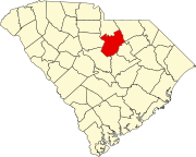
Abney Crossroads is an unincorporated community and census-designated place (CDP) in Kershaw County, South Carolina, United States. It was first listed as a CDP prior to the 2020 census.[3]
The CDP is in northern Kershaw County, along South Carolina Highway 341, which leads northwest 5 miles (8 km) to Kershaw and southeast 12 miles (19 km) to Bethune.
Demographics
| Census | Pop. | Note | %± |
|---|---|---|---|
| 2020 | 101 | — | |
| U.S. Decennial Census[4] | |||
References
- ^ "ArcGIS REST Services Directory". United States Census Bureau. Retrieved October 15, 2022.
- ^ "Census Population API". United States Census Bureau. Retrieved October 15, 2022.
- ^ a b "Abney Crossroads Census Designated Place". Geographic Names Information System. United States Geological Survey, United States Department of the Interior.
- ^ "Census of Population and Housing". Census.gov. Retrieved June 4, 2016.
- v
- t
- e
Municipalities and communities of Kershaw County, South Carolina, United States
County seat: Camden
- Abney Crossroads
- Boykin
- East Camden
- Lugoff
communities
- South Carolina portal
- United States portal
 | This South Carolina state location article is a stub. You can help Wikipedia by expanding it. |
- v
- t
- e


