Abu Sidrah
Village in Al-Shahaniya, Qatar
Abu Sidrah أَبُو سِدْرَة | |
|---|---|
Village | |
| 25°43′23″N 51°00′15″E / 25.72306°N 51.00417°E / 25.72306; 51.00417[1] | |
| Country |  Qatar Qatar |
| Municipality | Al-Shahaniya |
| Zone | Zone 73 |
Abu Sidrah (Arabic: أَبُو سِدْرَة, romanized: Abū Sidrah) is a village in northwest Qatar located in the municipality of Al-Shahaniya.[2][3] According to the Ministry of Environment, there were about five households in the village in 2014.[4]
It is accessible through Al Jemailiya Road. The settlements of Al Suwaihliya, to the north, and Al Jemailiya, to the south, are nearby.[3]
Etymology
"Abu" in Arabic means "father", and is commonly used as a prefix for geographical features. The "sidrah" component refers to Ziziphus nummularia, a tree that frequently occurs around the rawda (depression) which the village is centered around.[3]
Gallery
-
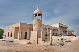 Small mosque in Abu Sidrah

References
- ^ "Abū Sidrah: Qatar". geographic.org. Retrieved 3 January 2019.
- ^ "Qatar Development Atlas - Part 1" (PDF). Ministry of Development Planning and Statistics. 2010. p. 10. Archived from the original (PDF) on 18 July 2020. Retrieved 2 January 2019.
- ^ a b c "District map". The Centre for Geographic Information Systems of Qatar. Archived from the original on 24 November 2020. Retrieved 2 January 2019.
- ^ Paul Sillitoe (1 August 2014). Sustainable Development: An Appraisal from the Gulf Region. Berghahn Books. p. 230. ISBN 9781782383727.
- v
- t
- e
 Al-Shahaniya Municipality
- Al Utouriya
- Lehsain
- Qaryat Al Refaiq
- Ras Abrouq
- Umm Al Daah Khawzan
- Umm Al Qahab Al Jadeeda
- Umm Al Qahab Al Qadeema
- Umm Leghab West
- Wadi Laswaq
- Zekreet
- Al Jemailiya
- Abu Sidrah
- Al Qa'iya
- Al Suwaihliya
- Al Shahaniya City
- Al Khurayb
- Al Samriya
- Lehsiniya
- Umm Leghab
- Rawdat Rashed
- Abu Nakhla
- Al Sahla Al Shamaliya
- Madinat Al Mawater
- Umm Al Maqarin
- Umm Al Zubar Al Qibliya
- Umm Al Zubar East
- Umm Ghuwailina
- Umm Lebrak
- Umm Wishah
- Wadi Lejmal Al Shamali
- Umm Bab
- Al Hamla
- Al Shabhana
- Jelaiha
- Qaryat Al Muhanna
- Dukhan
- Afjan
- Al Khattiya
- Al Ruwais West
- Al Zeghain
- Al-Shahaniya Camel Racetrack
- Sheikh Faisal Bin Qassim Al Thani Museum
 Category:Al-Shahaniya
 | This Qatari location article is a stub. You can help Wikipedia by expanding it. |
- v
- t
- e


