Admiralty Island
Island in southeast Alaska, US
57°44′N 134°20′W / 57.733°N 134.333°W / 57.733; -134.333
United States
| Admiralty Island National Monument | |
|---|---|
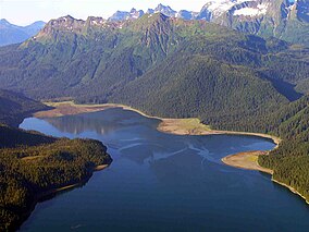 Windfall Harbor | |
  | |
| Location | Alaska, United States |
| Nearest city | Juneau, AK |
| Coordinates | 57°37′05″N 134°09′40″W / 57.61806°N 134.16111°W / 57.61806; -134.16111[1] |
| Area | 955,747 acres (3,867.77 km2) |
| Governing body | U.S. Forest Service |
| Website | www.fs.usda.gov/recarea/tongass/recarea/?recid=78614 |
U.S. National Monument | |
| Designated | 1978 |
Admiralty Island is an island in the Alexander Archipelago in Southeast Alaska, at 57°44′N 134°20′W / 57.733°N 134.333°W / 57.733; -134.333. It is 145 km (90 mi) long and 56 km (35 mi) wide with an area of 4,264.1 km2 (1,646.4 sq mi), making it the seventh-largest island in the United States and the 132nd largest island in the world. It is one of the ABC islands in Alaska. The island is nearly cut in two by the Seymour Canal; to its east is the long, narrow Glass Peninsula. Most of Admiralty Island—955,747 acres (3,868 km2)—is protected as the Admiralty Island National Monument administered by the Tongass National Forest. The Kootznoowoo Wilderness encompasses vast stands of old-growth temperate rainforest. These forests provide some of the best habitat available to species such as brown bears, bald eagles, and Sitka black-tailed deer.
Angoon, a traditional Tlingit community home to 572 people, is the only settlement on the island, although an unpopulated section of the city of Juneau comprises 264.68 km2 (102.19 sq mi) (6.2 percent) of the island's land area near its northern end. The island's total population at the 2000 census was 650.
The national monument is considered sacred space to the Angoon Tribe of Tlingit people, who live on tribal land in the community of Angoon on the western coast of the island. The Tlingits fought to make protection for the island a part of ANILCA legislation, and continue to engage in stewardship of the island's natural resources. Most of Angoon's residents make daily subsistence use of the national monument.[2]
History
It is known to the Tlingit as Xootsnoowú, which is commonly interpreted as "Fortress of the Bear(s)", and gives its name to hooch.
The island was named by British naval officer George Vancouver in honor of his Royal Navy employers, the Admiralty. Joseph Whidbey, master of the Discovery during Vancouver's 1791–95 expedition, explored it in July–August 1794, in the process circumnavigating it.[3]
The Admiralty Island National Monument was created December 1, 1978, by President Jimmy Carter. In the Alaska National Interest Lands Conservation Act Congress designated all but 18,351 acres (74.26 km2) (74 km2) of the monument as the Kootznoowoo Wilderness, ensuring that the vast bulk of this monument is permanently protected from development. The monument is administered by the U.S. Forest Service from offices in Juneau.
In 1986 it was named a biosphere reserve along with Glacier Bay National Park.[citation needed]
Ecology
Western hemlock, Sitka spruce and western redcedar dominate the prolific rainforest vegetation; wildlife in abundance includes brown bear, bald eagles, many species of salmon, whales, and deer. Admiralty Island is home to the highest density of brown bears in North America. An estimated 1,600 brown bears inhabit the island, outnumbering Admiralty's human residents nearly three to one. It has more brown bears than the entire lower 48 states, and one of the highest densities of bald eagles in the world.[4]
Whaling

Murder Cove is located at the southernmost portion of the island and was home to the Tyee Company whaling station.
Mining
The Greens Creek mine is an underground silver, gold, zinc and lead mine located on the northwest end of the island, within the national monument. It began operations in 1989.
Recreation
Admiralty Island offers opportunities for outdoor recreation. The 32-mile Cross Admiralty Canoe Route is a popular destination for backcountry canoeing and kayaking, traversing the breadth of the island through a series of lakes, streams and trail portages, with several cabins and shelters along the way.[5] While the modern route was laid out and constructed by the Civilian Conservation Corps in the 1930s, it follows traces long used by the island's native inhabitants for hunting, fishing and trading.[6]
The Pack Creek Brown Bear Viewing Area offers visitors the opportunity to observe brown bears in their natural habitat as they fish for salmon and interact with one another during the summer months. Permits are required for all visitors to Pack Creek; they can be obtained through the Forest Service.
Over recent decades, various fishing and outdoor recreation lodges have opened up on the island with most of these lodges operating in the Tlingit town of Angoon. There’s also one lodge on a small, privately held plot of land within the national monument.
Lighthouse
The Point Retreat Light is located on the northern tip of Admiralty and was an important aid-to-navigation.
See also
 Alaska portal
- List of national monuments of the United States
- USS Gambier Bay- U.S. Navy aircraft carrier named after Gambier Bay, east of Angoon, Alaska, sunk in the Battle off Samar in October 1944

Citations
- ^ "Admiralty Island National Monument". Geographic Names Information System. United States Geological Survey, United States Department of the Interior. Retrieved November 18, 2013.
- ^ Admiralty Island National Monument/Kootznoowoo Wilderness, USDA Forest Service, MB-R10-190. (1992)
- ^ Vancouver, George; John Vancouver (1801). A voyage of discovery to the North Pacific ocean, and round the world. Vol. I–VI. London: J. Stockdale.
- ^ "Admiralty Island National Monument". United States Forest Service.
- ^ Cross Admiralty Canoe Route Archived August 12, 2017, at the Wayback Machine, SEATrails.
- ^ Civilian Conservation Corps Properties in Alaska Archived August 20, 2014, at the Wayback Machine, Alaska Department of Natural Resources.
General and cited sources
- Admiralty Island: Blocks 1000 to 1002, Census Tract 6, Juneau City and Borough; Blocks 3012 to 3018; 3022 to 3026; Block 3048; Blocks 3056 to 3069; Block 3074; Blocks 3087 and 3088; Census Tract 3, Skagway-Hoonah-Angoon Census Area, Alaska United States Census Bureau
- Comparison of Predicted and Actual Water Quality at Hardrock Mines
External links
Wikimedia Commons has media related to Admiralty Island, Alaska.
- "Admiralty Island National Monument". Tongass National Forest. U.S. Forest Service. Archived from the original on August 5, 2006. Retrieved August 13, 2006.
- "Tongass National Forest". U.S. Forest Service. Archived from the original on August 10, 2006. Retrieved August 13, 2006.
- "Admiralty Island" . New International Encyclopedia. 1905.
- v
- t
- e
National monuments of the United States
- African Burial Ground
- Agate Fossil Beds
- Alibates Flint Quarries
- Aniakchak
- Aztec Ruins
- Bandelier
- Belmont-Paul Women's Equality
- Birmingham Civil Rights
- Booker T. Washington
- Buck Island Reef
- Cabrillo
- Camp Nelson
- Canyon de Chelly
- Cape Krusenstern
- Capulin Volcano
- Casa Grande Ruins
- Castillo de San Marcos
- Castle Clinton
- Castle Mountains
- Cedar Breaks
- César E. Chávez
- Charles Young Buffalo Soldiers
- Chiricahua
- Colorado
- Craters of the Moon
- Devils Postpile
- Devils Tower
- Dinosaur
- Effigy Mounds
- El Malpais
- El Morro
- Emmett Till and Mamie Till-Mobley
- Florissant Fossil Beds
- Fort Frederica
- Fort Matanzas
- Fort McHenry
- Fort Monroe
- Fort Pulaski
- Fort Stanwix
- Fort Union
- Fossil Butte
- Freedom Riders
- George Washington Birthplace
- George Washington Carver
- Gila Cliff Dwellings
- Governors Island
- Grand Canyon–Parashant
- Grand Portage
- Hagerman Fossil Beds
- Hohokam Pima
- Hovenweep
- Jewel Cave
- John Day Fossil Beds
- Katahdin Woods and Waters
- Lava Beds
- Little Bighorn Battlefield
- Medgar and Myrlie Evers Home
- Mill Springs Battlefield
- Montezuma Castle
- Muir Woods
- Natural Bridges
- Navajo
- Oregon Caves
- Organ Pipe Cactus
- Petroglyph
- Pipe Spring
- Pipestone
- Poverty Point
- Rainbow Bridge
- Russell Cave
- Salinas Pueblo Missions
- Scotts Bluff
- Statue of Liberty
- Stonewall
- Sunset Crater Volcano
- Timpanogos Cave
- Tonto
- Tule Lake
- Tule Springs Fossil Beds
- Tuzigoot
- Virgin Islands Coral Reef
- Waco Mammoth
- Walnut Canyon
- Wupatki
- Yucca House
- Admiralty Island
- Baaj Nwaavjo I'tah Kukveni – Ancestral Footprints of the Grand Canyon
- Bears Ears
- Berryessa Snow Mountain
- Browns Canyon
- Camp Hale – Continental Divide
- Chimney Rock
- Giant Sequoia
- Gila Cliff Dwellings
- Misty Fjords
- Mount St. Helens
- Newberry
- Saint Francis Dam Disaster
- San Gabriel Mountains
- Sand to Snow
- Santa Rosa and San Jacinto Mountains
Land Management
- Agua Fria
- Avi Kwa Ame
- Baaj Nwaavjo I'tah Kukveni – Ancestral Footprints of the Grand Canyon
- Basin and Range
- Bears Ears
- Berryessa Snow Mountain
- Browns Canyon
- California Coastal
- Canyons of the Ancients
- Carrizo Plain
- Cascade–Siskiyou
- Craters of the Moon
- Fort Ord
- Gold Butte
- Grand Canyon–Parashant
- Grand Staircase–Escalante
- Ironwood Forest
- Jurassic
- Kasha-Katuwe Tent Rocks
- Mojave Trails
- Organ Mountains–Desert Peaks
- Pompeys Pillar
- Prehistoric Trackways
- Río Grande del Norte
- San Juan Islands
- Sand to Snow
- Santa Rosa and San Jacinto Mountains
- Sonoran Desert
- Upper Missouri River Breaks
- Vermilion Cliffs
AFRH, NOAA, USAF, Army)
- Aleutian Islands World War II
- Castner Range
- Hanford Reach
- Harriet Tubman Underground Railroad
- Marianas Trench Marine
- Military Working Dog Teams
- Northeast Canyons and Seamounts
- Pacific Remote Islands Marine
- Papahānaumokuākea Marine
- President Lincoln's Cottage at the Soldiers' Home
- Rose Atoll Marine
- Tule Lake
Authority control databases | |
|---|---|
| International |
|
| National |
|
| Other |
|


