Apuseni Natural Park
Romanian protected area
46°36′14″N 22°48′36″E / 46.604°N 22.810°E / 46.604; 22.810[1]
The Apuseni Natural Park (Romanian: Parcul Natural Apuseni) is a protected area (natural park category V IUCN) situated in Romania, in the administrative territory of counties Alba (28%), Bihor (32 %), and Cluj (40%).[2][3]
Location
The Natural Park is located in western Romania in the central-northern side of the Apuseni Mountains, comprising part of the Bihor Mountains to the south and Vlădeasa Mountains [ro] to the north. It is situated on the administrative territory of 16 communes, which include 53 localities fully and 8 others partially. The Park features 3 resorts: Boga, Fântânele, and Vârtop.[3]
Natural reserves
The Apuseni Natural Park with an area of 75,784 ha (187,270 acres)[4] was declared natural protected area by the Law Number 5 of March 6, 2000 (published in the Monitorul Oficial of Romania, Number 152 of April 12, 2000)[5] and represents a mountainous area (mountain peaks, cirques, caves, valleys, karst areas, forests, and pastures), with flora and fauna specific to the Western Carpathians.
Natural reserves included in the park:
- Alba County[6]

- Avenul din Hoanca Urzicarului [ro], 1 ha (2.5 acres)
- Coiba Mare Cave [ro], 0.5 ha (1.2 acres)
- Ghețarul de la Vârtop Cave [ro], 1 ha (2.5 acres)
- Izbucul de la Cotețul Dobreștilor [ro], 0.2 ha (0.49 acres)
- Izbucul Mătișești [ro], 2 ha (4.9 acres)
- Izbucul Tăuzului [ro], 1 ha (2.5 acres)
- Scărișoara Cave, 1 ha (2.5 acres)

- Bihor County[7]
- Avenul Borțigului [ro], 0.1 ha (0.25 acres)
- Bears' Cave, 1 ha (2.5 acres)
- Cârligați Peak [ro], 10 ha (25 acres)
- Cerbului Cave - Avenul cu Vacă [ro], 45 ha (110 acres)
- Cetatea Rădesei Cave [ro], 20 ha (49 acres)
- Cetățile Ponorului [ro], 14.9 ha (37 acres)
- Ciur Izbuc Cave [ro], 0.1 ha (0.25 acres)
- Fâneața Izvoarelor Crișul Pietros [ro], 1 ha (2.5 acres)
- Ghețarul Focul Viu Cave [ro], 0.1 ha (0.25 acres)
- Groapa de la Bârsa [ro], 30 ha (74 acres)
- Groapa Ruginoasa - Valea Seacă [ro], 20.4 ha (50 acres)
- Micula’s Cave [ro], 0.1 ha (0.25 acres)
- Pietrele Boghii [ro], 38.4 ha (95 acres)

- Pietrele Galbenei [ro], 6.3 ha (16 acres)
- Platoul carstic Lumea Pierdută [ro], 39 ha (96 acres)
- Platoul carstic Padiș [ro], 39 ha (96 acres)
- Poiana Florilor [ro], 1 ha (2.5 acres)
- Săritoarea Bohodeiului [ro], 32.9 ha (81 acres)
- Smeii de la Onceasa Cave [ro], 0.5 ha (1.2 acres)
- Valea Galbenei [ro], 70.5 ha (174 acres)
- Valea Sighiștelului [ro], 412.6 ha (1,020 acres)
- Vârful Biserica Moțului [ro], 3 ha (7.4 acres)
- Cluj County
- Molhașul Mare de la Izbuc [ro], 8 ha (20 acres)
Rivers and lakes

The surface waters of the Apuseni Natural Park belong to the hydrographic basins of the rivers:[8]
- Arieșul Mare and its tributaries, Gârda Seacă, Popasele [ro], and Cobleș.
- Someșul Mic and its left headwater, the Someșul Cald, together with the latter's tributaries, Alunul Mare [ro], Alunul Mic [ro], Beliș, Ponor [ro], Valea Firii [ro], Barna [ro], Valea Izbucului, and Călineasa.
- Crișul Negru and its tributaries, Crișul Pietros (together with its headwater, Galbena [ro], and its tributaries, Valea Mare Cărpinoasa and Căuși [ro]) and Crișul Băița (together with its tributaries, Hoanca Moțului [ro] and Sighiștel).

In the northern part of the park, there is the Beliș-Fântânele Lake [ro], a reservoir in the Gilău Mountains, built between 1970 and 1974. Located at an altitude of 1,050 m (3,440 ft), the reservoir covers an area of 826 ha (2,040 acres) and has a volume of 225–250 million cubic metres (0.054–0.060 cu mi) of water. It was formed after the damming of the Someșul Cald downstream of its confluence with the Beliș stream; the dam has a height of 92 m (302 ft) and a length of 410 m (1,350 ft). From the reservoir, the water is diverted through a 8.475 km (5.266 mi) tunnel to the turbines of the Mărișelu Hydroelectric Power Station.[8][9]
References
- ^ eunis.eea.europa.eu - Apuseni Natural Park (coords); retrieved on June 14, 2012
- ^ protectedplanet.net Apuseni Mountains Natural Park (location); retrieved on June 14, 2012
- ^ a b "Localizare". parcapuseni.ro (in Romanian). Parcul Natural Apuseni. Retrieved July 13, 2024.
- ^ (in Romanian) apmcj.anpm.ro - Agenția pentru Protecția Mediului Cluj; retrieved on June 14, 2012
- ^ (in Romanian) cdep.ro - Legea Nr.5 din 6 martie 2000, publicată în Monitorul Oficial al României, Nr.152 din 12 aprilie 2000; retrieved on June 14, 2012
- ^ (in Romanian) apmab.anpm.ro - Agenția pentru Protecția Mediului Alba; retrieved on June 14, 2012
- ^ (in Romanian) apmbh.anpm.ro - Agenția pentru Protecția Mediului Bihor; retrieved on June 14, 2012
- ^ a b "Hidrologie". parcapuseni.ro (in Romanian). Parcul Natural Apuseni. Retrieved July 13, 2024.
- ^ "Centralele Hidroelectrice Mărișelu și Remeți". www.hidroelectrica.ro (in Romanian). Hidroelectrica. Retrieved July 14, 2024.
-
![The Ponor Glade, the only example of polje in the Padiș Plateau [ro]](//upload.wikimedia.org/wikipedia/commons/thumb/0/01/Ponor_Glade.JPG/180px-Ponor_Glade.JPG) The Ponor Glade, the only example of polje in the Padiș Plateau [ro]
The Ponor Glade, the only example of polje in the Padiș Plateau [ro] -
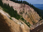 Ruginoasa pit
 -
 Map of the Padiș Plateau and surrounding area
![The Ponor Glade, the only example of polje in the Padiș Plateau [ro]](http://upload.wikimedia.org/wikipedia/commons/thumb/0/01/Ponor_Glade.JPG/180px-Ponor_Glade.JPG)


