Ayer Kuning
Mukim in Tampin, Negeri Sembilan, Malaysia
Mukim in Negeri Sembilan, Malaysia
Ayer Kuning | |
|---|---|
Mukim | |
| Country |  Malaysia Malaysia |
| State |  Negeri Sembilan Negeri Sembilan |
| District | Tampin |
| Luak | Ayer Kuning |
Luak Beradat in Negeri Sembilan, Malaysia
Ayer Kuning | |
|---|---|
Luak Beradat | |
| Luak Ayer Kuning لواق اءير كونيڠ | |
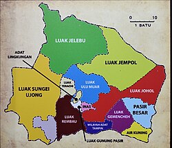 Luak of Ayer Kuning relative to other luaks in Negeri Sembilan | |
| Country | Malaysia |
| State | Negeri Sembilan |
| Adat institution | Undang of Johol |
| Government | |
| • Penghulu | Mohamad Ghazali Abdul Jalil |

Ayer Kuning (Jawi: اءير كونيڠ) is a mukim and new village in Tampin District, Negeri Sembilan, Malaysia.[1] It borders Nyalas and Asahan, Malacca to the southwest and south, and Jementah, Johor on the southeast. The 1,276-metre tall Mount Ledang stands majestically near the tripoint between these states.
Traditionally, it is a chiefdom (luak) under the protection of Johol.
References
- ^ "Archived copy" (PDF). Archived from the original (PDF) on 2020-11-26. Retrieved 2016-07-28.
{{cite web}}: CS1 maint: archived copy as title (link)
- v
- t
- e
Capital: Seremban, Royal town: Seri Menanti
- Elections
- Government
- Symbols
- Politics
divisions
| Luak (Domains) |
|
|---|---|
| Districts | |
| Towns |
|
| Townships | |
| Villages |
|
 Commons
 Wikisource
 Category

2°35′N 101°57′E / 2.59°N 101.95°E / 2.59; 101.95
 | This Negeri Sembilan location article is a stub. You can help Wikipedia by expanding it. |
- v
- t
- e


