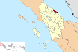
Batubara Regency
You can help expand this article with text translated from the corresponding article in Indonesian. (October 2017) Click [show] for important translation instructions.
- Machine translation, like DeepL or Google Translate, is a useful starting point for translations, but translators must revise errors as necessary and confirm that the translation is accurate, rather than simply copy-pasting machine-translated text into the English Wikipedia.
- Do not translate text that appears unreliable or low-quality. If possible, verify the text with references provided in the foreign-language article.
- You must provide copyright attribution in the edit summary accompanying your translation by providing an interlanguage link to the source of your translation. A model attribution edit summary is
Content in this edit is translated from the existing Indonesian Wikipedia article at [[:id:Kabupaten Batu Bara]]; see its history for attribution. - You may also add the template
{{Translated|id|Kabupaten Batu Bara}}to the talk page. - For more guidance, see Wikipedia:Translation.
Regency in North Sumatra, Indonesia
Coat of arms
Sejahtera Berjaya
(Prosperous and Successful)
(Prosperous and Successful)
(mid 2023 estimate)[1]
Batubara Regency is a regency on North Sumatra's eastern shoreline, with the town of Limapuluh as the seat of its administration. It was carved out from the seven most westerly coastal districts of Asahan Regency with effect from 15 June 2007. The new regency covers an area of 887.88 km2, and had a population of 375,885 at the 2010 Census[2] and 410,678 at the 2020 Census,[3] of whom 206,551 were male and 204,127 were female; the official estimate as at mid 2023 was 430,533 - comprising 216,549 males and 213,984 females.[1] It's quite densely populated compared to countries like China or Japan.
Administrative districts
From 2007 until 2017 the regency was divided administratively into seven districts (kecamatan), but at the end of 2017 five additional districts were created by the division of four of the existing districts. The districts are tabulated below from east to west with their areas and their populations at the 2010 Census[2] and the 2020 Census,[3] together with the official estimates as at mid 2023.[1] The table also includes the locations of the district administrative centres, the number of administrative villages in each district (totaling 141 rural desa and 10 urban kelurahan), and its post code:
| Kode Wilayah | Name of District (kecamatan) | Area in km2 | Pop'n Census 2010 | Pop'n Census 2020 | Pop'n Estimate mid 2023 | Admin centre | No. of villages | Post code |
|---|---|---|---|---|---|---|---|---|
| 12.19.07 | Sei Balai | 85.39 | 26,857 | 29,541 | 31,021 | Sei Balai | 14 | 21252 |
| 12.19.06 | Tanjung Tiram (a) | 13.17 | 62,964 | 35,662 | 36,673 | Tanjung Tiram | 10 (b) | 21253 |
| 12.19.12 | Nibung Hangus | 127.95 | (c) | 31,206 | 32,855 | Ujung Kubu | 12 | 21253 |
| 12.19.05 | Talawi | 48.09 | 53,585 | 31,912 | 33,706 | Labuhan Ruku | 10 (d) | 21254 |
| 12.19.11 | Datuk Tanah Datar | 49.24 | (e) | 26,903 | 28,025 | Karang Baru | 10 | 21254 |
| 12.19.04 | Lima Puluh | 102.80 | 85,164 | 35,623 | 37,180 | Lima Puluh Kota | 12 (d) | 21255 |
| 12.19.09 | Lima Puluh Pesisir (Coastal Lima Puluh) | 80.85 | (f) | 34,921 | 37,559 | Perupuk | 13 | 21255 |
| 12.19.10 | Datuk Lima Puluh | 59.59 | (f) | 24,432 | 25,446 | Simpang Dolok | 10 | 21255 |
| 12.19.03 | Air Putih | 81.27 | 46,749 | 51,959 | 54,728 | Indrapura | 19 (b) | 21256 |
| 12.19.02 | Sei Suka | 73.49 | 52,599 | 33,648 | 34,922 | Sei Suka/Deras | 10 (d) | 21257 |
| 12.19.08 | Laut Tador | 82.71 | (g) | 21,747 | 22,520 | Perkebunan Tanjung Kasau | 10 | 21257 |
| 12.19.01 | Medang Deras | 83.33 | 47,967 | 53,124 | 55,898 | Pangkalan Dodek | 21 (h) | 21258 |
| Totals | 887.88 | 375,885 | 410,678 | 430,533 | Lima Puluh | 151 |
Note: (a) includes the small offshore islands of Pandang and Salahnama. (b) including 2 kelurahan.
(c) the 2010 population of the new Nibung Hangus District is included with the figure for Tanjung Tiram District, from which it was cut out. (d) including one kelurahan.
(e) the 2010 population of the new Datuk Tanah Datar District is included with the figure for Talawi District, from which it was cut out. (f) the 2010 population of the new Lima Puluh Pesisir and Datuk Lima Puluh Districts are included with the figure for Lima Puluh District, from which they were cut out. (g) the 2010 population of the new Laut Tador District is included with the figure for Sei Suka District, from which it was cut out. (h) including 3 kelurahan.
Transport
On 27 January 2015 groundbreaking for the new Kuala Tanjung Port began. The port will accommodate 60 million TEUs (twenty-foot equivalent units) per year as the biggest port in West Indonesia, bigger than Tanjung Priok Port, in Jakarta with only 15 million TEUs per year.[4]
References
- ^ a b c Badan Pusat Statistik, Jakarta, 28 February 2024, Kabupaten Batubara Dalam Angka 2024 (Katalog-BPS 1102001.1219)
- ^ a b Biro Pusat Statistik, Jakarta, 2011.
- ^ a b Badan Pusat Statistik, Jakarta, 2021.
- ^ "Presiden: Pelabuhan Kuala Tanjung Bakal Besar Sekali". January 27, 2015.
- v
- t
- e
Capital: Medan
- Asahan
- Batubara
- Dairi
- Deli Serdang
- Humbang Hasundutan
- Karo
- Labuhan Batu
- South Labuhan Batu
- North Labuhan Batu
- Langkat
- Mandailing Natal
- Nias
- West Nias
- South Nias
- North Nias
- Padang Lawas
- North Padang Lawas
- Pakpak Bharat
- Samosir
- Serdang Bedagai
- Simalungun
- South Tapanuli
- Central Tapanuli
- North Tapanuli
- Toba

- Binjai
- Gunung Sitoli
- Medan
- Padang Sidempuan
- Pematangsiantar
- Sibolga
- Tanjungbalai
- Tebing Tinggi
3°00′00″N 99°10′00″E / 3°N 99.1667°E / 3; 99.1667
 | This North Sumatra location article is a stub. You can help Wikipedia by expanding it. |
- v
- t
- e


