Beatton Provincial Park

Canadian provincial park
56°19′39″N 120°56′39″W / 56.32750°N 120.94417°W / 56.32750; -120.94417Area330 ha. (3.3 km²)EstablishedSeptember 14, 1934Governing bodyBC ParksWebsitebcparks.ca/beatton-park/

Beatton Provincial Park is a provincial park in the Peace River Country of northeastern British Columbia, Canada.

It is located on the Eastern shores of Charlie Lake approximately sixteen kilometers from Fort St John, BC. The 320 hectare provincial park offers facilities that include vehicle accessible camping, boat launch, drinking water, picnic area, pit toilets, playground and a large trail system. The provincial campground only operates between May and September, but the park trail system is open year-round.

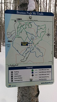
The park's large trail network is maintained by the Whiskey Jack Nordic Ski Club[1] and is used for cross-country skiing and snowshoeing in the winter and hiking in the summer. There are over 20 km of groomed cross-country ski trails designed for beginner, intermediate and advancing skiers and a toboggan hill located near the parking at the main gate.

Beatton Provincial Park Picnic Shelter
Beatton Provincial Park Trail Map

See also

References

  1. ^ "Club Directory | Cross Country BC". www.crosscountrybc.ca. Retrieved 2015-11-22.

External links

  • Official website
  • "Beatton Park". BC Geographical Names.


  • v
  • t
  • e
  • v
  • t
  • e
World Heritage Sites
Biosphere Reserves
National Parks
Marine Conservation Areas
National Historic Sites
National Wildlife Areas
Migratory Bird Sanctuaries
Marine Protected Areas
Marine Refuges
  • Gwaxdlala/Nalaxdlala (Lull/Hoeya)
  • Offshore Pacific Seamounts and Vents
  • Strait of Georgia and Howe Sound Glass Sponge Reef
Parks
Alberni-Clayoquot RD
Bulkley-Nechako RD
Capital RD
Cariboo RD
Central Coast RD
Central Kootenay RD
Central Okanagan RD
Columbia-Shuswap RD
Comox Valley RD
Cowichan Valley RD
East Kootenay RD
Fraser-Fort George RD
Fraser Valley RD
Kitimat-Stikine RD
Kootenay Boundary RD
Metro Vancouver RD
Mount Waddington RD
Nanaimo RD
North Coast RD
North Okanagan RD
Northern Rockies RM
Okanagan-Similkameen RD
Peace River RD
qathet RD
Squamish-Lillooet RD
Stikine Region
Strathcona RD
Sunshine Coast RD
Thompson-Nicola RD
Conservancies
Ecological reserves
Protected areas
Recreation areas
Wildlife Management Areas
Other

56°18′39″N 120°56′52″W / 56.31083°N 120.94778°W / 56.31083; -120.94778 (Beatton Provincial Park)