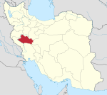
Beyranvand-e Jonubi Rural District
Rural district in Lorestan province, Iran
Rural District in Lorestan, Iran
Beyranvand-e Jonubi Rural District Persian: دهستان بيرانوند جنوبي | |
|---|---|
| 33°37′57″N 48°35′48″E / 33.63250°N 48.59667°E / 33.63250; 48.59667[1] | |
| Country | Iran |
| Province | Lorestan |
| County | Khorramabad |
| District | Beyranvand |
| Population (2016)[2] | |
| • Total | 6,547 |
| Time zone | UTC+3:30 (IRST) |
Beyranvand-e Jonubi Rural District (Persian: دهستان بيرانوند جنوبي) is in Beyranvand District[a] of Khorramabad County, Lorestan province, Iran.[4]
Demographics
Population
At the time of the 2006 National Census, the rural district's population was 6,309 in 1,359 households.[5] There were 5,994 inhabitants in 1,567 households at the following census of 2011.[6] The 2016 census measured the population of the rural district as 6,547 in 1,752 households. The most populous of its 71 villages was Namaklan-e Olya, with 540 people.[2]
Notes
- ^ Formerly Chaghalvandi District[3]
See also
 Iran portal
References
- ^ OpenStreetMap contributors (26 August 2023). "Beyranvand-e Jonubi Rural District (Khorramabad County)" (Map). OpenStreetMap (in Persian). Retrieved 26 August 2023.
- ^ a b "Census of the Islamic Republic of Iran, 1395 (2016)". AMAR (in Persian). The Statistical Center of Iran. p. 15. Archived from the original (Excel) on 12 October 2020. Retrieved 19 December 2022.
- ^ Rahimi, Mohammadreza (14 August 2017). "Six changes in the map of country divisions of Lorestan and Sistan and Baluchestan provinces". DOLAT (in Persian). Ministry of Interior, Cabinet of Ministers. Archived from the original on 4 August 2018. Retrieved 16 April 2023.
- ^ "Approval of the organization and chain of citizenship of the elements and units of the country divisions of Lorestan province, centered in the city of Khorramabad". Lamtakam (in Persian). Ministry of Interior, Political and Defense Commission of the Government Board. 21 June 1369. Archived from the original on 19 January 2024. Retrieved 19 January 2024.
- ^ "Census of the Islamic Republic of Iran, 1385 (2006)". AMAR (in Persian). The Statistical Center of Iran. p. 15. Archived from the original (Excel) on 20 September 2011. Retrieved 25 September 2022.
- ^ "Census of the Islamic Republic of Iran, 1390 (2011)". Syracuse University (in Persian). The Statistical Center of Iran. p. 15. Archived from the original (Excel) on 19 January 2023. Retrieved 19 December 2022.
- v
- t
- e
Lorestan Province, Iran

| Aligudarz County | |
|---|---|
| Azna County | |
| Borujerd County | |
| Delfan County | |
| Dorud County | |
| Dowreh County | |
| Khorramabad County | |
| Kuhdasht County | |
| Pol-e Dokhtar County | |
| Rumeshkan County | |
| Selseleh County |
- Falak-ol-Aflak Castle
- Gerdab-e Sangi
- Keeyow Lake
- Brick Minaret
- Imamzadeh Ja'far
- Soltani Mosque
- Jameh Mosque
- Women's Park of Borujerd
- Yafteh
- Nojian Waterfall
- Bisheh Waterfall
- Gerit Waterfall
- Imamzadeh Do Baradaran
- Shapuri Bridge
- Kashkan Bridge
- Zardabeh Lagoon
- Gahar Lake
- Sheneh Castle
- Rahmanabad Sasanian Palace
- Gosheh Caravansary
 | This Khorramabad County location article is a stub. You can help Wikipedia by expanding it. |
- v
- t
- e


