Blace, Konjic
Village in Federation of Bosnia and Herzegovina, Bosnia and Herzegovina
Blace Блаце | |
|---|---|
Village | |
| 43°37′01″N 18°07′01″E / 43.61694°N 18.11694°E / 43.61694; 18.11694 | |
| Country |  Bosnia and Herzegovina Bosnia and Herzegovina |
| Entity | Federation of Bosnia and Herzegovina |
| Canton |  Herzegovina-Neretva Herzegovina-Neretva |
| Municipality |  Konjic Konjic |
| Area | |
| • Total | 10.93 sq mi (28.31 km2) |
| Population (2013) | |
| • Total | 0 |
| • Density | 0.0/sq mi (0.0/km2) |
| Time zone | UTC+1 (CET) |
| • Summer (DST) | UTC+2 (CEST) |
Blace (Cyrillic: Блаце) is a village in the municipality of Konjic, Bosnia and Herzegovina.[1]
Blace village (1,215 m) is located in close proximity to the Blatačko Lake on a karstic plateau of the Bjelašnica mountain, on the very edge of the Rakitnica canyon.
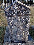
National monument
Blace In combination with lake's natural position. and surrounding space's rich cultural-historical heritage, with prehistoric grave mounds, medieval necropolises with stećak and nišani tombstones, in and around the village, forming one combined cultural landscape with part of the deep Rakitnica canyon, and is designated as a National Monument of Bosnia and Herzegovina.[2]
Demographics
According to the 2013 census, its population was nil, down from 21 in 1991.[3]
References
- ^ Official results from the book: Ethnic composition of Bosnia-Herzegovina population, by municipalities and settlements, 1991. census, Zavod za statistiku Bosne i Hercegovine - Bilten no.234, Sarajevo 1991.
- ^ "Blatačko Lake, cultural landscape - Commission to preserve national monuments". old.kons.gov.ba. 2009. Retrieved 31 May 2018.
- ^ "Naseljena Mjesta 1991/2013" (in Bosnian). Statistical Office of Bosnia and Herzegovina. Retrieved October 2, 2021.
- v
- t
- e
Settlements of Konjic
- Argud
- Bale
- Bare
- Barmiš
- Bijela
- Bjelovčina
- Blace
- Blučići
- Borci
- Boždarevići
- Bradina
- Brđani
- Budišnja Ravan
- Bukovica
- Bukovlje
- Bulatovići
- Bušćak
- Buturović Polje
- Čelebići
- Čelina
- Cerići
- Česim
- Čičevo
- Crni Vrh
- Čuhovići
- Dobričevići
- Dolovi
- Doljani
- Donja Vratna Gora
- Donje Selo
- Donje Višnjevice
- Donji Čažanj
- Donji Gradac
- Donji Nevizdraci
- Donji Prijeslop
- Došćica
- Dubočani
- Dubravice
- Dudle
- Dužani
- Džajići
- Džanići
- Džepi
- Falanovo Brdo
- Gakići
- Galjevo
- Glavatičevo
- Gobelovina
- Gorani
- Goransko Polje
- Gorica
- Gornja Vratna Gora
- Gornje Višnjevice
- Gornji Čažanj
- Gornji Gradac
- Gornji Nevizdraci
- Gostovići
- Grabovci
- Gradeljina
- Grušča
- Hasanovići
- Herići
- Homatlije
- Homolje
- Hondići
- Idbar
- Jasenik
- Javorik
- Ježeprosina
- Jezero
- Jošanica
- Kale
- Kanjina
- Kašići
- Konjic
- Kostajnica
- Koto
- Krajkovići
- Kralupi
- Krtići
- Krupac
- Krušćica
- Kula
- Lađanica
- Lisičići
- Ljesovina
- Ljubuča
- Ljuta
- Lokva
- Luka
- Lukomir
- Lukšije
- Mladeškovići
- Mokro
- Mrkosovice
- Obrenovac
- Obri
- Odžaci
- Orahovica
- Orlište
- Oteležani
- Ovčari
- Pačerani
- Parsovići
- Plavuzi
- Podhum
- Podorašac
- Pokojište
- Polje Bijela
- Požetva
- Prevlje
- Radešine
- Raotići
- Rasvar
- Razići
- Redžići
- Repovci
- Repovica
- Ribari
- Ribići
- Seljani
- Seonica
- Sitnik
- Slavkovići
- Solakova Kula
- Sopot
- Spiljani
- Stojkovići
- Strgonice
- Studenčica
- Sultići
- Šunji
- Svijenča
- Tinje
- Tovarnica
- Treboje
- Trešnjevica
- Trusina
- Tuhobići
- Turija
- Ugošće
- Veluša
- Vinište
- Vrbljani
- Vrci
- Vrdolje
- Zabrđani
- Zabrđe
- Zagorice
- Zaslivlje
- Zukići
 | This Herzegovina-Neretva Canton geography article is a stub. You can help Wikipedia by expanding it. |
- v
- t
- e


