Bonham Road
Main road in Mid-Levels West, Hong Kong
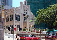
 View of Bonham Road facing St. Anthony's Church | |
| Length | 1.3 km (0.81 mi) |
|---|---|
| Area | Sai Ying Pun/Mid-Levels |
| West end | Pok Fu Lam Road, Hill Road |
| East end | Caine Road |
| Bonham Road | |||||||||||||
|---|---|---|---|---|---|---|---|---|---|---|---|---|---|
| Chinese | 般咸道 般含道 | ||||||||||||
| |||||||||||||
Bonham Road is a main road in West Mid-Levels, Hong Kong Island in Hong Kong, running mainly East-West. The road connects Pok Fu Lam Road in the west, near the University of Hong Kong, and Caine Road in the east, at the junction with Hospital Road and Seymour Road. It was named after Sir George Bonham, the third Governor of Hong Kong.[1] It was renamed Nishi-Taisho Dori (西大正通) during Japanese occupation of Hong Kong.
Features
Several historical buildings are located on the road, including Fung Ping Shan building, Hung Hing Ying building and the Main Building of The University of Hong Kong. There are also a few well known schools located on the road, including King's College, St. Paul's College, Hong Kong, St. Stephen's Girls' College, St. Clare's Primary School, Bonham Road Government Primary School, Chinese Rhenish Church Hong Kong which is there in the 19th century.
Bonham Road Flyover
Bonham Road Flyover is a one-way, single-lane flyover allowing vehicles travelling north on Pok Fu Lam Road to turn east onto Bonham Road. It was completed in 1973.
Landmarks
Community Facilities
Transport
Education
- University of Hong Kong
- St. Stephen's Girls' College
- King's College, Hong Kong
- St. Paul's College, Hong Kong
- St. Stephen's Church College
- Bonham Road Government Primary School
- St. Claire's Primary School
Religious
- Chinese Rehinish Church (Hong Kong)
- Hop Yat Church (Hong Kong)
- St. Anthony's Church (Hong Kong)
Nature
Military
- 88 Bonham Road - Western Barracks (Bonham Tower Barracks) of the Hong Kong Garrison
Intersecting roads
Listed from West to East:
- Pok Fu Lam Road
- Hill Road
- Hing Hon Road (Private Road)
- Western Street
- Honiton Road
- Centre Street (pedestrianised)
- Park Road (Hong Kong)
- Breezy Path
- Hospital Road
- Seymour Road (Hong Kong)
- Caine Road
See also
References
- ^ Yanne, Andrew; Heller, Gillis (2009). Signs of a Colonial Era. Hong Kong University Press. pp. 45–46. ISBN 9789622099449.
External links
Wikimedia Commons has media related to Bonham Road.
- v
- t
- e
Main borders and locations
- Landmarks in Central
- Bank of America Tower
- Bonham Road
- British Consulate
- Breezy Path
- Central and Western Heritage Trail
- Civic Square
- First houses on the Peak
- Gate Lodge
- Grenville House
- Harcourt Garden
- Headquarters House
- High West
- Hong Kong Museum of Medical Sciences
- Hong Kong Zoological and Botanical Gardens
- Island Pacific Hotel
- King George V Memorial Park
- Lippo Centre
- Lung Fu Shan Country Park
- Mount Davis
- Mountain Lodge
- Ohel Leah Synagogue
- Old Tsan Yuk Maternity Hospital
- The Peak Galleria
- Hong Kong Trams Station (former)
- Pacific Place Phases I-II
- Peak Tower
- Queensway
- Sai Ying Pun Community Complex
- SoHo
- Shun Tak Centre
- South Korean Consulate
- Smithfield
- Tamar Park
- Tim Mei Avenue
- Tsan Yuk Hospital
- Victoria Peak Garden
| MTR stations |
|
|---|---|
| Ferry terminals | |
| Tram |
This list is incomplete. Central has its own template due to the number of sites in that area.
Sites specifically associated with University of Hong Kong are listed at the relevant template.
Sites specifically associated with University of Hong Kong are listed at the relevant template.


22°17′03″N 114°08′33″E / 22.2842°N 114.1424°E / 22.2842; 114.1424
 | This Hong Kong road article is a stub. You can help Wikipedia by expanding it. |
- v
- t
- e


