Canton of Bain-de-Bretagne
Canton in Brittany, France
Bain-de-Bretagne | |
|---|---|
Canton | |
 | |
| Country | France |
| Region | Brittany |
| Department | Ille-et-Vilaine |
| No. of communes | 20 |
| Seat | Bain-de-Bretagne |
| Area | 461.85 km2 (178.32 sq mi) |
| Population (2021)[1] | 32,530 |
| • Density | 70/km2 (200/sq mi) |
| INSEE code | 35 02 |
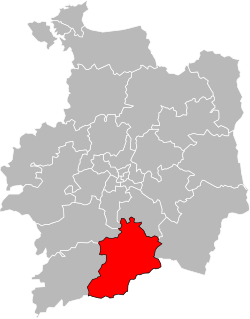
The Canton of Bain-de-Bretagne is a canton of France, in the Ille-et-Vilaine département, located in the southeast of the department. At the French canton reorganisation which came into effect in March 2015, the canton was expanded from 9 to 20 communes:[2]
- Bain-de-Bretagne
- La Bosse-de-Bretagne
- Chanteloup
- La Couyère
- Crevin
- La Dominelais
- Ercé-en-Lamée
- Grand-Fougeray
- Lalleu
- La Noë-Blanche
- Pancé
- Le Petit-Fougeray
- Pléchâtel
- Poligné
- Saint-Sulpice-des-Landes
- Sainte-Anne-sur-Vilaine
- Saulnières
- Le Sel-de-Bretagne
- Teillay
- Tresbœuf
References
- ^ "Téléchargement du fichier d'ensemble des populations légales en 2021" (in French). The National Institute of Statistics and Economic Studies. 28 December 2023.
- ^ Décret n° 2014-177 du 18 février 2014 portant délimitation des cantons dans le département d'Ille-et-Vilaine
- v
- t
- e

(27 cantons)
(53 cantons)
- Antrain
- Argentré-du-Plessis
- Bain-de-Bretagne
- Bécherel
- Betton
- Bruz
- Cancale
- Cesson-Sévigné
- Châteaubourg
- Châteaugiron
- Châteauneuf-d'Ille-et-Vilaine
- Combourg
- Dinard
- Dol-de-Bretagne
- Fougères-Nord
- Fougères-Sud
- Grand-Fougeray
- Guichen
- Hédé
- Janzé
- La Guerche-de-Bretagne
- Le Sel-de-Bretagne
- Liffré
- Louvigné-du-Désert
- Maure-de-Bretagne
- Montauban-de-Bretagne
- Montfort-sur-Meu
- Mordelles
- Pipriac
- Pleine-Fougères
- Plélan-le-Grand
- Redon
- Rennes-Brequigny
- Rennes-Centre
- Rennes-Centre-Ouest
- Rennes-Centre-Sud
- Rennes-Est
- Rennes-le-Blosne
- Rennes-Nord
- Rennes-Nord-Est
- Rennes-Nord-Ouest
- Rennes-Sud-Est
- Rennes-Sud-Ouest
- Retiers
- Saint-Aubin-d'Aubigné
- Saint-Aubin-du-Cormier
- Saint-Brice-en-Coglès
- Saint-Malo-Nord
- Saint-Malo-Sud
- Saint-Méen-le-Grand
- Tinténiac
- Vitré-Est
- Vitré-Ouest
47°51′50″N 1°39′59″W / 47.8639°N 1.6665°W / 47.8639; -1.6665
 | This Ille-et-Vilaine geographical article is a stub. You can help Wikipedia by expanding it. |
- v
- t
- e


