Cape D'Aguilar
Cape on Hong Kong Island, Hong Kong
| Cape D'Aguilar | |||||||
|---|---|---|---|---|---|---|---|
 Cape D'Aguilar | |||||||
| Traditional Chinese | 鶴咀 | ||||||
| Literal meaning | Crane Beak | ||||||
| |||||||

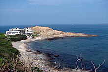
Cape D'Aguilar (Chinese: 鶴咀) is a cape on Hong Kong Island, Hong Kong. The cape is on the southeastern end of D'Aguilar Peninsula. To its north are Shek O and D'Aguilar Peak.
Name
It is named after Major-General George Charles d'Aguilar.
Geography
Cape D'Aguilar is in the Southern District.[1] Nearby, there are two small islands collectively called Kau Pei Chau (狗髀洲). A channel called Sheung Sze Mun (雙四門) is located close to the cape.
Marine Reserve
Cape D'Aguilar is environmentally protected as part of the Cape D'Aguilar Marine Reserve.
Sightseeings
Common sightseeings for visitors include the Bones of Miss Willy, a whale's skeleton display mounted in front of the University of Hong Kong's Swire Institute of Marine Science.
The Crab's Eye is a sea cave off the Cape D'Aguilar Road, connected to the Thunder Cave. It is also a popular sightseeing point for tourists.
Another popular sightseeing point is the Bokhara Battery, the remains of an artillery battery that is used during the Battle of Hong Kong.[2]
See also
 Engineering portal
 Hong Kong portal


- Cape D'Aguilar Lighthouse
- Green Island Lighthouse Compound
- Waglan Lighthouse
- Tang Lung Chau Lighthouse
References
- ^ "District Council Constituency Boundaries - Southern District (Sheet 2)" (PDF). Electoral Affairs Commission. Retrieved 12 April 2021.
- ^ Historic building appraisal aab.gov.hk
External links
Wikimedia Commons has media related to D'Aguilar Peninsula.
- Satellite image of the peninsula by Google Maps
- Cape D’Aguilar Lighthouse video on YouTube
- v
- t
- e
Main borders and locations
- Canadian International School of Hong Kong
- Ebenezer School & Home for the Visually Impaired
- German Swiss International School Pok Fu Lam Campus
- Hong Kong International School
- Hong Kong True Light College
- Kellett School Pok Fu Lam Campus
- Sacred Heart Canossian College
- Singapore International School
- St Stephen's College
- South Island School
- West Island School
- Aberdeen Country Park
- Béthanie
- Central Ordnance Munitions Depot
- Cyberport
- D'Aguilar Peak
- The Duchess of Kent Children's Hospital at Sandy Bay
- Grantham Hospital
- Holy Spirit Seminary
- Hong Kong Parkview
- Kwun Yam Shrine
- Hong Kong Chinese Christian Churches Union Pok Fu Lam Road Cemetery
- Middle Bay
- Murray House
- Ocean Park Hong Kong
- Queen Mary Hospital
- Pok Fu Lam Country Park
- The Pulse
- The Repulse Bay
- Shek O Country Park
- Shouson Hill
- South Horizons
- Stanley Military Cemetery
- Stanley Prison
- Tai Tam Country Park
| Moved | |
|---|---|
| Beaches |
| Closed |
|---|
| MTR stations |
|---|
- Ap Lei Chau (Aberdeen Island)
- Ap Lei Pai
- Kau Pei Chau
- Magazine Island
- Middle Island (Tong Po Chau)
- Tai Tau Chau
22°12′28″N 114°15′38″E / 22.20778°N 114.26056°E / 22.20778; 114.26056

| Authority control databases: Cape D'Aguilar Lighthouse |
|
|---|
 | This Hong Kong Island location article is a stub. You can help Wikipedia by expanding it. |
- v
- t
- e


