Chiradzulu District
District of Malawi
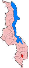
Chiradzulu is a district in the Southern Region of Malawi. The capital is Chiradzulu. The district covers an area of 761 km.² and has a population of 356,875
Demographics
At the time of the 2018 Census of Malawi, the distribution of the population of Chiradzulu District by ethnic group was as follows:[1]
- 69.3% Lomwe
- 18.6% Yao
- 4.2% Ngoni
- 3.2% Chewa
- 1.9% Nyanja
- 1.7% Mang'anja
- 0.4% Sena
- 0.3% Tumbuka
- 0.1% Tonga
- 0.0% Nkhonde
- 0.0% Lambya
- 0.0% Sukwa
- 0.2% Others
Government and administrative divisions
There are five National Assembly constituencies in Chiradzulu:
- Chiradzulu - Central
- Chiradzulu - East
- Chiradzulu - North
- Chiradzulu - South
- Chiradzulo - West
Since the 2009 general election all of these constituencies have been represented by politicians from the Democratic Progressive Party.[2]
See also
- Masanjala
References

15°42′S 35°10′E / 15.700°S 35.167°E / -15.700; 35.167
 | This Malawi location article is a stub. You can help Wikipedia by expanding it. |
- v
- t
- e


