County Durham (district)
Unitary authority area in County Durham, England
Unitary authority area in England
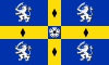
Flag

Coat of arms

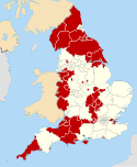
Shown within ceremonial County Durham
6 MPs
- Luke Akehurst (L)
- Mary Kelly Foy (L)
- Grahame Morris (L)
- Sam Rushworth (L)
- Alan Strickland (L)
- Liz Twist (L)
(2022)[3]
List
- 54.6% Christianity
- 38.6% no religion
- 0.6% Islam
- 0.2% Buddhism
- 0.2% Hinduism
- 0.2% Sikhism
- 0.1% Judaism
- 0.4% other
- 5.1% not stated
DH1–99
County Durham is a local government district in the ceremonial county of County Durham, England. It is governed by Durham County Council, a unitary authority.[5] The district has an area of 2,226 square kilometres (859 sq mi), and contains 135 civil parishes.[6] It forms part of the larger ceremonial county of Durham, together with boroughs of Darlington, Hartlepool, and the part of Stockton-on-Tees north of the River Tees.
History
Between 1974 and 1 April 2009, County Durham was governed as a two-tier non-metropolitan county, with a county council and district councils. The original eight districts were Chester-le-Street, Darlington, Derwentside, Durham (city), Easington, Sedgefield, Teesdale, and Wear Valley.[7] In 1997 Darlington was removed from the non-metropolitan county and became a separate unitary authority.[8] In 2009 the remaining districts were abolished and replaced by a single district covering the non-metropolitan county, with Durham County Council as the sole local authority.[9]
Geography
The district has multiple hamlets and villages. Settlements with town status include Consett, Barnard Castle, Peterlee, Seaham, Bishop Auckland, Newton Aycliffe, Middleton-in-Teesdale, Shildon, Chester-le-Street, Crook, Stanley, Willington, Stanhope, Spennymoor, Ferryhill and Sedgefield while Durham is the only city in the district.[citation needed]
| Local authority | In relation to the district |
|---|---|
| Northumberland | North |
| Gateshead | North east |
| City of Sunderland | North east |
| Hartlepool | South east |
| Stockton-on-Tees | South east |
| Darlington | South |
| North Yorkshire | South |
| Westmorland and Furness | West |
Governance
Following the 2021 United Kingdom local elections, the council is now[when?] under control of a coalition of the Liberal Democrats, Conservative Party, Independents and North East Party.[citation needed]
Education
Durham LEA has a comprehensive school system with 36 state secondary schools (not including sixth form colleges) and five independent schools (four in Durham and one in Barnard Castle). Easington district has the largest school population by year, and Teesdale has the smallest with two schools. Only one school in Easington and Derwentside districts have sixth forms, with about half the schools in the other districts having sixth forms.[citation needed]
Notes
References
- ^ "Councillors and MPs". Durham County Council. Retrieved 13 July 2024.
- ^ "Mid-Year Population Estimates, UK, June 2022". Office for National Statistics. 26 March 2024. Retrieved 3 May 2024.
- ^ "Mid-Year Population Estimates, UK, June 2022". Office for National Statistics. 26 March 2024. Retrieved 3 May 2024.
- ^ a b UK Census (2021). "2021 Census Area Profile – County Durham Local Authority (E06000047)". Nomis. Office for National Statistics. Retrieved 13 July 2024.
- ^ "Durham unitary authority approved". BBC News. 25 July 2007. Retrieved 1 August 2021.
- ^ "County Durham". Ordnance Survey. Retrieved 23 May 2021.
- ^ "Durham council leader explains the benefits of a becoming large unitary authority". The Northern Echo. 2 March 2021. Retrieved 1 August 2021.
- ^ "The Durham (Borough of Darlington) (Structural Change) Order 1995". legislation.gov.uk. Retrieved 18 June 2023.
- ^ "The County Durham (Structural Change) Order 2008". legislation.gov.uk. Retrieved 18 June 2023.
External links
- Durham County Council information from GeoPunk
- Durham County Council information from Alan Godfrey Maps
- v
- t
- e
- Borough of Darlington
- Borough of Hartlepool
- Borough of Stockton-on-Tees (part)
- County Durham
(cities in italics)
- Barnard Castle
- Billingham
- Bishop Auckland
- Chester-le-Street
- Chilton
- Consett
- Crook
- Darlington
- Durham
- Eaglescliffe
- Easington Colliery
- Ferryhill
- Hartlepool
- Middleton-in-Teesdale
- Newton Aycliffe
- Peterlee
- Seaham
- Sedgefield
- Shildon
- Spennymoor
- Stanhope
- Stanley
- Stockton-on-Tees
- Tow Law
- Wolsingham
See also: Durham