Dok-do
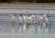
Dok-do (덕도, 德島) is a small, rocky island in the north-eastern Yellow Sea lying about 15 km off the western coast of North Korea, administered under Onchon County. It rises to a height of 85 m and has an area of 18 ha. Based on surveys conducted in 1997 and 1998, the site has been identified by BirdLife International as an Important Bird Area (IBA) because it supports small numbers of breeding endangered black-faced spoonbills and vulnerable Chinese egrets. The island has been classified as one of the Natural monuments of North Korea, No.37. The main threat to the birds is from human disturbance.[1][2]
References
- ^ "Dok-do island". Important Bird Areas factsheet. BirdLife International. 2013. Archived from the original on 2007-07-10. Retrieved 2013-04-20.
- ^ Chong Jong-Ryol & Pak U.-Il (2000). Ueta, M.; Kurosawa, R. & Allen, D. (eds.). The breeding sites and distribution of Black-faced Spoonbills Platalea minor in the Democratic People's Republic of Korea (DPRK). In: "Conservation and research of Black-faced Spoonbills and their habitats" (PDF). Tokyo: Wild Bird Society of Japan. pp. 5–9.
- v
- t
- e
Important Bird Areas of North Korea
- Amrok River estuary
- Anbyon Field
- Batoggisem, Dansem and Zamori Islands
- Chongchon River
- Chongdan Field
- Daedong Bay
- Dok-do
- Kangryong Field
- Kumya Bay
- Lake Bujon
- Lake Kwangpo
- Lakes Manpo and Bonpo
- Lake Rangrim
- Lake Samilpo
- Lakes Tungjong and Chonapo
- Mayang Reservoir
- Mount Chilbo
- Mount Kumgang
- Mount Kuwol
- Mount Myohyang
- Mount Oga
- Mount Paekdu
- Oksem, Dongsolbatsem, Sesolbatsem and Namsolbatsem Islands
- Onchon Field
- Ongjin Bay
- Orangchon River estuary
- Panmun Field
- Rab-do and Muki-do Islands
- Ryonghung Gang estuary
- Sogam-do, Daegam-do, Zung-do, Ae-do and Hyengzedo Islands
- Taedong River estuary
- Unmu-do
- Unryul Kumsanpo
38°44′57″N 124°58′8″E / 38.74917°N 124.96889°E / 38.74917; 124.96889
 | This North Korea location article is a stub. You can help Wikipedia by expanding it. |
- v
- t
- e


