Dorset, Ohio
Unincorporated community in Ohio, U.S.
Dorset is an unincorporated community in central Dorset Township, Ashtabula County, Ohio, United States.[1] It has a post office with the ZIP code 44032.[2] It lies along State Route 193.
Dorset was originally named Millsford, and under the latter name was founded in 1828.[3] The present name is after Dorset, Vermont, the native home of an early settler.[3]
John Brown Junior, son of John Brown the abolitionist, lived in Dorset from approximately 1855 to 1885.
Historical Photos
<details> <summary>Click to view the Historical Photos</summary>
-
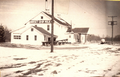 Milk factory in Dorset Ohio. Located at the intersection of Footville Richmond Road and State Route 307, on the East side of Mill Creek.
 -
 Train at Dorset Station in Dorset Ohio
 -
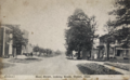
 North on 193 in Dorset Ohio
 -
 Mill and Hotel in Dorset
 -
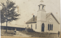 Dorset Baptist Chruch
 -
 Class photo in front of the school in Dorset.
 -
 This store appears to be the same as another photo that I have posted, only difference being the addition of a gas station.
 -
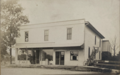
 Appears to have been one of the many stores in Dorset, I am unsure of the location.
 -
 Looking North on State Route 193, second house on the left appears to be roughly where the Township garage is now located.
 -
 Store fronts in Dorset Ohio
 -
 Some sort of community event in Dorset Ohio
 -
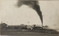
 Mine prop shipment Dorset Ohio
 -
 Railroad Tower possibly located on the west side of Tower Road in Dorset Ohio
 -
 One of the first schools located in Dorset Ohio
 -
 Early car, photo taken in Dorset Ohio
 -
 Log shipment in Dorset Ohio
 -
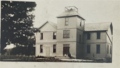
 Hotel and Mill located in Dorset Ohio
 -
 Home and barn in photo located to the left of the Dorset school in Dorset Ohio
 -
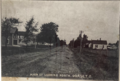
 Train station in Dorset
 -
 Stores fronts located in Dorset Ohio
 -
 State Route 193 looking North in Dorset Ohio. Block home on the left side of the photo would later become the bakery and game room after.
 -
 Train Station in Dorset Ohio


</details>
References
- v
- t
- e
Municipalities and communities of Ashtabula County, Ohio, United States
County seat: Jefferson
- Ashtabula
- Conneaut
- Geneva

- Andover
- Geneva-on-the-Lake
- Jefferson
- North Kingsville
- Orwell
- Roaming Shores
- Rock Creek
communities
‡This populated place also has portions in an adjacent county or counties
- Ohio portal
- United States portal
41°40′49″N 80°40′02″W / 41.68028°N 80.66722°W / 41.68028; -80.66722
 | This Ashtabula County, Ohio state location article is a stub. You can help Wikipedia by expanding it. |
- v
- t
- e


