Embudo, New Mexico
Unincorporated community in Rio Arriba County, New Mexico, United States
Unincorporated community in New Mexico, United States
36°12′27″N 105°57′40″W / 36.20750°N 105.96111°W / 36.20750; -105.96111[1]
United States historic place
Embudo Historic District | |
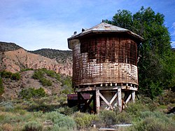 Old railroad water tower at the Embudo Station | |
  | |
| Location | New Mexico State Road 68, Embudo, New Mexico |
|---|---|
| Area | 18 acres (7.3 ha) |
| Built | 1880 (1880) |
| NRHP reference No. | 79001547[2] |
| NMSRCP No. | 485 |
| Significant dates | |
| Added to NRHP | March 12, 1979 |
| Designated NMSRCP | January 20, 1977 |
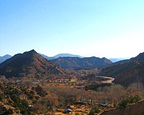
Embudo (also Embudo Station) is an unincorporated community in Rio Arriba County, New Mexico, United States. The community runs along both sides of the Rio Grande on New Mexico State Road 68, beginning at Embudo Station located 2.9 miles (4.7 km) south of the intersection of New Mexico State Road 75, near where the Embudo Creek (Rio Embudo) flows into the Rio Grande, encompassing the communities of La Bolsa and Rinconada and ending at the Taos County Line.
Etymology
The name "Embudo", meaning "funnel" in Spanish, was given to the area by early Spanish settlers because the spot where the Rio Embudo flowed between two distinctive cone shaped hills reminded them of a funnel.
Embudo was founded in 1881 when the Denver and Rio Grande Western Railroad opened a station (depot) there on its Chili Line. The station was named after the village San Antonio de Embudo,[3] located two miles up the Embudo Creek, and until 1902 the communities shared a post office and were known jointly as Embudo. In 1900, anticipating a separate post office in the village, San Antonio de Embudo changed its name to Dixon after the Presbyterian missionary Dixon, who established a mission there. When the Dixon post office opened in 1902, however, Embudo lost its post office. Embudo got a post office again in 1905, only to lose it in 1909. In 1914, Embudo once again had its own post office,[3] zip code 87531, but the building was removed in 2016, and mailboxes were transferred to the Dixon post office.
Transport links
Today, from the state road a concrete bridge, replacing the old wooden bridge, crosses the Rio Grande to the "Embudo Historic District" which consists of the old railway station and associated buildings. The United States Geological Survey (USGS) gauging station at Embudo, to measure the flow of the Rio Grande, was the first (USGS) stream gauging station and was established by John Wesley Powell in 1888. Embudo was also the first USGS training center for hydrographers.[4]
Embudo was originally on U.S. Route 64 (US 64), a major national east-west highway and the main route between Santa Fe and Taos. In 1974 US 64 was realigned to end at Tonopah, Arizona rather than Santa Fe bypassing Embudo.
Notable people
- Casimiro Barela, Colorado politician
- Susan K. Herrera, member of the New Mexico House of Representatives
- Raul Midón, musician
- Ra Paulette, cave sculptor
Gallery
-
 View of the mesa in 1885. The tracks for the Chili Line, now gone, can be seen in the foreground.
 -
 NM Route 68 to Taos at right.
 -
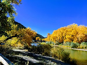 Rio Grande just upstream from the Embudo Bridge
 -
![Gas-alley-boy at Johnnie Meier Classical Gas Museum in Embudo.[5]](//upload.wikimedia.org/wikipedia/commons/thumb/a/a5/Gas-alley-boy.jpg/127px-Gas-alley-boy.jpg) Gas-alley-boy at Johnnie Meier Classical Gas Museum in Embudo.[5]
Gas-alley-boy at Johnnie Meier Classical Gas Museum in Embudo.[5]


![Gas-alley-boy at Johnnie Meier Classical Gas Museum in Embudo.[5]](http://upload.wikimedia.org/wikipedia/commons/thumb/a/a5/Gas-alley-boy.jpg/127px-Gas-alley-boy.jpg)
See also
 National Register of Historic Places portal

References
- ^ a b U.S. Geological Survey Geographic Names Information System: Embudo, New Mexico
- ^ "National Register Information System". National Register of Historic Places. National Park Service. July 9, 2010.
- ^ a b Julyan, Robert Hixson (1998). The place names of New Mexico (2nd ed.). Albuquerque, New Mexico: University of New Mexico Press. p. 123. ISBN 0-8263-1688-3.
"Embudo" The place names of New Mexico
- ^ ""Embudo Stream-Gauging Station (Established in 1888)" New Mexico Historic Markers". Archived from the original on May 9, 2007. Retrieved February 11, 2008.
- ^ McCarten, Neala (April 20, 2016). Offbeat New Mexico: Places of Unexpected History, Art, and Culture. ISBN 978-0997332216.
External links
Wikimedia Commons has media related to Embudo, New Mexico.
- "Offbeat New Mexico: Places of Unexpected History, Art, and Culture"
- "National Register of Historic Places: New Mexico - Rio Arriba County - Historic Districts"
- noaa.gov: Rio Grande at Embudo
- v
- t
- e
Municipalities and communities of Rio Arriba County, New Mexico, United States
County seat: Tierra Amarilla

- Abiquiú
- Alcalde
- Brazos
- Canjilon
- Cañones
- Canova
- Chamita
- Chili
- Chimayo‡
- Cordova
- Coyote
- Dixon
- Dulce
- El Duende
- El Rito
- Ensenada
- Gallina
- Hernandez
- La Madera
- La Mesilla
- La Villita
- Lindrith
- Los Luceros
- Los Ojos
- Lumberton
- Lybrook
- Lyden
- Medanales
- Ohkay Owingeh
- Ojo Caliente‡
- Ojo Sarco
- Pueblito
- Rio Chiquito‡
- San Jose
- San Juan
- Santa Clara Pueblo
- Tierra Amarilla
- Truchas
- Velarde
- Youngsville
communities
former settlements
reservations
‡This populated place also has portions in an adjacent county or counties
- New Mexico portal
- United States portal
| |
|---|---|
| Topics | |
| Lists by state |
|
| Lists by insular areas | |
| Lists by associated state | |
| Other areas | |
| Related | |
| |

| Authority control databases: Geographic |
|
|---|


