Französische Straße (Berlin U-Bahn)
| Preceding station | Berlin U-Bahn | Following station | ||
|---|---|---|---|---|
| Former service | ||||
| Friedrichstraße towards Alt-Tegel | U6 | Stadtmitte towards Alt-Mariendorf | ||

Location | |
|---|---|
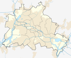
  Französische Straße Location within Berlin |
Französische Straße was a Berlin U-Bahn underground station on the U6 line located under the street Friedrichstraße in central Berlin.
This station was built by Grenander/Fehse/Jennen and opened in 1923. In 1945 it closed for a few months; it was closed in 1961. During the Cold War (1961–1990), the station became a ghost station. The station was closed to passenger traffic, and the underground trains of the West Berlin BVG passed the island platform in East Berlin slowly without stopping. In 1990, after the Berlin Wall fell, the station became accessible again. In 1995, the platform had to be lengthened by 25 m (82 ft) so that the longer, six-car trains could stop there.[2] It is the only former partition-related ghost station in Berlin to have since been closed a second time, albeit for different reasons.

2020 closure
With the opening of the expanded U5 line connecting Alexanderplatz with Berlin Hauptbahnhof, Französische Straße station was closed and replaced by the newly built Unter den Linden station directly to the north,[3] allowing transfers between the U6 and U5 lines. The last trains called at Französische Straße on 3 December 2020, with Unter den Linden station opening the following day.
References
- ^ "Der VBB-Tarif: Aufteilung des Verbundgebietes in Tarifwaben und Tarifbereiche" (PDF). Verkehrsbetrieb Potsdam. Verkehrsverbund Berlin-Brandenburg. 1 January 2017. Archived from the original (PDF) on 27 October 2020. Retrieved 25 November 2019.
- ^ J. Meyer-Kronthaler: Berlins U-Bahnhöfe. be.bra Verlag (1996)
- ^ "FAQ - Frequently Asked Questions". Projektrealisierungs GmbH U5. Retrieved 29 June 2017.
- v
- t
- e

- Warschauer Straße
- Stralauer Tor (dismantled)
- Schlesisches Tor
- Görlitzer Bahnhof
- Kottbusser Tor
- Prinzenstraße
- Hallesches Tor
- Möckernbrücke
- Gleisdreieck
- Kurfürstenstraße
- Nollendorfplatz
- Wittenbergplatz
- Kurfürstendamm
- Uhlandstraße
- Pankow
- Vinetastraße
- Schönhauser Allee
- Eberswalder Straße
- Senefelderplatz
- Rosa-Luxemburg-Platz
- Alexanderplatz
- Klosterstraße
- Märkisches Museum
- Spittelmarkt
- Hausvogteiplatz
- Stadtmitte
- Mohrenstraße
- Potsdamer Platz
- Mendelssohn-Bartholdy-Park
- Gleisdreieck
- Bülowstraße
- Nollendorfplatz
- Wittenbergplatz
- Zoologischer Garten
- Ernst-Reuter-Platz
- Deutsche Oper
- Bismarckstraße
- Sophie-Charlotte-Platz
- Kaiserdamm
- Theodor-Heuss-Platz
- Neu-Westend
- Olympia-Stadion
- Ruhleben
- Warschauer Straße
- Stralauer Tor (dismantled)
- Schlesisches Tor
- Görlitzer Bahnhof
- Kottbusser Tor
- Prinzenstraße
- Hallesches Tor
- Möckernbrücke
- Gleisdreieck
- Kurfürstenstraße
- Nollendorfplatz
- Wittenbergplatz
- Augsburger Straße
- Nürnberger Platz (dismantled)
- Spichernstraße
- Hohenzollernplatz
- Fehrbelliner Platz
- Heidelberger Platz
- Rüdesheimer Platz
- Breitenbachplatz
- Podbielskiallee
- Dahlem-Dorf
- Freie Universität (Thielplatz)
- Oskar-Helene-Heim
- Onkel Toms Hütte
- Krumme Lanke
- Nollendorfplatz
- Viktoria-Luise-Platz
- Bayerischer Platz
- Rathaus Schöneberg
- Innsbrucker Platz
- Hauptbahnhof
- Bundestag
- Brandenburger Tor
- Unter den Linden
- Museumsinsel
- Rotes Rathaus
- Alexanderplatz
- Schillingstraße
- Strausberger Platz
- Weberwiese
- Frankfurter Tor
- Samariterstraße
- Frankfurter Allee
- Magdalenenstraße
- Lichtenberg
- Friedrichsfelde
- Tierpark
- Biesdorf-Süd
- Elsterwerdaer Platz
- Wuhletal
- Kaulsdorf Nord
- Kienberg (Gärten der Welt)
- Cottbusser Platz
- Hellersdorf
- Louis-Lewin-Straße
- Hönow
- Alt-Tegel
- Borsigwerke
- Holzhauser Straße
- Otisstraße
- Scharnweberstraße
- Kurt-Schumacher-Platz
- Afrikanische Straße
- Rehberge
- Seestraße
- Leopoldplatz
- Wedding
- Reinickendorfer Straße
- Schwartzkopffstraße
- Naturkundemuseum
- Oranienburger Tor
- Friedrichstraße
- Unter den Linden
- Französische Straße (closed)
- Stadtmitte
- Kochstraße
- Hallesches Tor
- Mehringdamm
- Platz der Luftbrücke
- Paradestraße
- Tempelhof
- Alt Tempelhof
- Kaiserin-Augusta-Straße
- Ullsteinstraße
- Westphalweg
- Alt-Mariendorf
- Rathaus Spandau
- Altstadt Spandau
- Zitadelle
- Haselhorst
- Paulsternstraße
- Rohrdamm
- Siemensdamm
- Halemweg
- Jakob-Kaiser-Platz
- Jungfernheide
- Mierendorffplatz
- Richard-Wagner-Platz
- Bismarckstraße
- Wilmersdorfer Straße
- Adenauerplatz
- Konstanzer Straße
- Fehrbelliner Platz
- Blissestraße
- Berliner Straße
- Bayerischer Platz
- Eisenacher Straße
- Kleistpark
- Yorckstraße
- Möckernbrücke
- Mehringdamm
- Gneisenaustraße
- Südstern
- Hermannplatz
- Rathaus Neukölln
- Karl-Marx-Straße
- Neukölln
- Grenzallee
- Blaschkoallee
- Parchimer Allee
- Britz-Süd
- Johannisthaller Chaussee
- Lipschitzallee
- Wutzkyallee
- Zwickauer Damm
- Rudow
- Wittenau
- Rathaus Reinickendorf
- Karl-Bonhoeffer-Nervenklinik
- Lindauer Allee
- Paracelsus-Bad
- Residenzstraße
- Franz-Neumann-Platz
- Osloer Straße
- Pankstraße
- Gesundbrunnen
- Voltastraße
- Bernauer Straße
- Rosenthaler Platz
- Weinmeisterstraße
- Alexanderplatz
- Jannowitzbrücke
- Heinrich-Heine-Straße
- Moritzplatz
- Kottbusser Tor
- Schönleinstraße
- Hermannplatz
- Boddinstraße
- Leinestraße
- Hermannstraße
- Osloer Straße
- Nauener Platz
- Leopoldplatz
- Amrumer Straße
- Westhafen
- Birkenstraße
- Turmstraße
- Hansaplatz
- Zoologischer Garten
- Kurfürstendamm
- Spichernstraße
- Güntzelstraße
- Berliner Straße
- Bundesplatz
- Friedrich-Wilhelm-Platz
- Walther-Schreiber-Platz
- Schloßstraße
- Rathaus Steglitz
52°30′53″N 13°23′21″E / 52.51472°N 13.38917°E / 52.51472; 13.38917
 | This Berlin U-Bahn-related article is a stub. You can help Wikipedia by expanding it. |
- v
- t
- e
This article about a railway station in Berlin is a stub. You can help Wikipedia by expanding it. |
- v
- t
- e


