Gobinda Chandra Khatik Road
Road in Kolkata, India
22°33′0.72″N 88°23′7.44″E / 22.5502000°N 88.3854000°E / 22.5502000; 88.3854000
Gobinda Chandra Khatick Road (formerly Hughes Road) is a famous thoroughfare in the city of Kolkata (formerly Calcutta), India.[3][4] The road runs past Grace Ling Liang Church, Tangra Police Station, and largely through the China Town areas of Tangra in East Kolkata and crosses Pulin Khatik Road and Christopher Road at separate intersections. Gobinda Chandra Khatik road is 2.1 kilometers in length from the Tangra Slaughterhouse to the Topsia Junction.[5] It demarcated the Eastern Fringes of the city at a time when Chinese operated Tanneries and Leatherworks dominated the area. Nowadays, China Town is a haven of Indo Chinese Fusion food and has crafted a legacy in its own right.[citation needed] Initially called Hughes Road until 1985, the name was renamed to recognise the contribution of Late Gobinda Khatik. Recent Urbanization and rapid growth has rapidly changed the landscape of Tangra and traffic snarls on the once empty road are common. The road is long and narrow and caters to Bi-Directional traffic. Dhangars, a community of Untouchable sanitary workers established their colony along this road. The road falls under Ward no. 56, 59, and 66 of the KMC.[citation needed]
Gallery
-
 John Burdon Sanderson Haldane Avenue (JBS Haldane Avenue) & Gobinda Chandra Khatik Road Crossing, Kolkata
 -
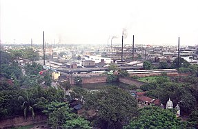
 The Topsia crossing or JBS Haldane avenue and Gobinda Chandra Khatik Road crossing of Kolkata. This photograph was taken from the Vishwakarma Building.
 -
 The Topsia crossing or J B S Haldane avenue and Gobinda Chandra Khatik Road crossing of Kolkata, where the Science City is seen in the background. This photograph was taken from the Vishwakarma Building.
 -
 The small leather factories of the Topsia crossing or JBS Haldane avenue and Gobinda Chandra Khatik Road crossing of Kolkata. This photograph was taken from the Vishwakarma Building.


See also
- Streets in Kolkata
References
- ^ "Gobinda Chandra Khatik Road" (Map). Google Maps. Retrieved 6 June 2019.
- ^ https://www.kmcgov.in/KMCPortal/downloads/MO_NUHM_22_04_2017.pdf [bare URL PDF]
- ^ "Man dies in bid to board moving bus in Kolkata". The Times of India. 1 March 2019. Retrieved 29 June 2019.
- ^ "Kolkata Municipal Corporation" (PDF). KMCPortal. 29 June 2019.
- ^ Nair, P. Thankappan (1987). A history of Calcutta's streets. Firma KLM. p. 86.
- v
- t
- e
Streets in Kolkata
- AJC Bose Road & APC Road
- Amherst Street
- Ballygunge Circular Road
- Bowbazar Street
- Bidhan Sarani
- Camac Street
- Chittaranjan Avenue
- Chowringhee Road
- College Street
- Gariahat Road
- Gurusaday Dutta Road
- Grey Street
- Hare Street
- Lindsay Street
- Lansdowne Road
- Mahatma Gandhi Road
- Mirza Ghalib Street
- Netaji Subhas Road
- Netaji Subash Chandra Bose Road
- Park Street
- Prince Anwar Shah Road
- Rabindra Sarani
- Raja Nabakrishna Street
- Raja SC Mullick Road
- Rashbehari Avenue
- Shakespeare Sarani
- Southern Avenue
- Strand Road
- Sudder Street
- V.I.P. Road
- Vivekananda Road
- Zakaria Street
- Neighbourhoods in Kolkata
- Kolkata topics
 India portal


