Grade II* listed buildings in Wycombe
Map all coordinates using OpenStreetMap
Download coordinates as:
- KML
- GPX (all coordinates)
- GPX (primary coordinates)
- GPX (secondary coordinates)
There are over 20,000 Grade II* listed buildings in England. This page is a list of these buildings in the district of Wycombe in Buckinghamshire.
List
| Name | Location | Type | Completed [note 1] | Date designated | Grid ref.[note 2] Geo-coordinates | Entry number [note 3] | Image |
|---|---|---|---|---|---|---|---|
| Church of St Mary | Saunderton, Bledlow-cum-Saunderton, Wycombe | Parish Church | 14th century | 21 June 1955 | SP7955501890 51°42′36″N 0°51′00″W / 51.710114°N 0.849998°W / 51.710114; -0.849998 (Church of St Mary) | 1332059 | 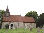 More images |
| Forty Green Farmhouse | Forty Green, Bledlow-cum-Saunderton | Farmhouse | 1718 | 21 June 1955 | SP7662803312 51°43′24″N 0°53′31″W / 51.723304°N 0.89204°W / 51.723304; -0.89204 (Forty Green Farmhouse) | 1332060 |  Upload Photo |
| Manor House | Bledlow, Bledlow-cum-Saunderton | House | c. 1670 | 21 June 1955 | SP7796402132 51°42′45″N 0°52′23″W / 51.712512°N 0.872966°W / 51.712512; -0.872966 (Manor House) | 1125803 | Upload Photo |
| The Old House Farmhouse | Bledlow-cum-Saunderton | Farmhouse | Late 15th century | 21 June 1955 | SP7905701896 51°42′37″N 0°51′26″W / 51.710238°N 0.857203°W / 51.710238; -0.857203 (The Old House Farmhouse) | 1310782 | Upload Photo |
| Bradenham Manor | Bradenham | House | 16th century | 21 June 1955 | SU8287797081 51°39′59″N 0°48′11″W / 51.666405°N 0.80307°W / 51.666405; -0.80307 (Bradenham Manor) | 1332048 | 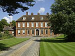 More images |
| Church of St Botolph | Bradenham | Parish Church | c. 1100 | 21 June 1955 | SU8283497126 51°40′01″N 0°48′13″W / 51.666815°N 0.803681°W / 51.666815; -0.803681 (Church of St Botolph) | 1125779 | 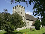 More images |
| The White House | Bradenham | House | c. 1800 | 21 June 1955 | SU8269597132 51°40′01″N 0°48′20″W / 51.66689°N 0.805689°W / 51.66689; -0.805689 (The White House) | 1310723 |  More images |
| Church of St Peter and St Paul | Ellesborough | Parish Church | late C14-C15 | 21 June 1955 | SP8363706739 51°45′11″N 0°47′23″W / 51.753109°N 0.78977°W / 51.753109; -0.78977 (Church of St Peter and St Paul) | 1125881 | 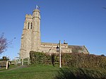 More images |
| Wellwick Manor | Ellesborough | House | 17th century | 25 October 1951 | SP8523807884 51°45′47″N 0°45′59″W / 51.763161°N 0.766302°W / 51.763161; -0.766302 (Wellwick Manor) | 1118401 | 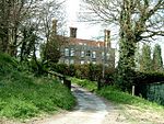 More images |
| Wellwick Manor | Wendover | House | 17th century | 25 October 1951 | SP8523707886 51°45′47″N 0°45′59″W / 51.763179°N 0.766316°W / 51.763179; -0.766316 (Wellwick Manor) | 1332019 | More images |
| Church of St Mary the Virgin | Fawley | Parish Church | 12th century | 21 June 1955 | SU7535486716 51°34′27″N 0°54′51″W / 51.574285°N 0.91405°W / 51.574285; -0.91405 (Church of St Mary the Virgin) | 1125702 |  More images |
| Freeman Mausoleum | Fawley | Mausoleum | 1750 | 7 February 1980 | SU7531686718 51°34′28″N 0°54′53″W / 51.574308°N 0.914598°W / 51.574308; -0.914598 (Freeman Mausoleum) | 1125703 |  More images |
| Church of St Mary Magdalene | Great and Little Hampden | Parish Church | 13th century | 21 June 1955 | SP8484502369 51°42′49″N 0°46′24″W / 51.713646°N 0.773338°W / 51.713646; -0.773338 (Church of St Mary Magdalene) | 1158762 | 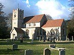 More images |
| Widmere Farmhouse | Widmere, Great Marlow | Farmhouse | late C17-early 18th century | 21 June 1955 | SU8319889195 51°35′44″N 0°48′01″W / 51.595468°N 0.800301°W / 51.595468; -0.800301 (Widmere Farmhouse) | 1332119 | Upload Photo |
| Church of St Mary | Hambleden | Parish Church | 12th century | 21 June 1955 | SU7839986604 51°34′22″N 0°52′13″W / 51.572863°N 0.870145°W / 51.572863; -0.870145 (Church of St Mary) | 1160018 |  More images |
| Greenlands (part of Henley Business School) | Greenlands, Hambleden | Country House | c. 1810 | 4 December 1992 | SU7757085483 51°33′46″N 0°52′56″W / 51.5629°N 0.882352°W / 51.5629; -0.882352 (Greenlands (part of Henley Business School)) | 1125682 |  More images |
| Hambleden Manor House | Hambleden | House | Early 17th century | 21 June 1955 | SU7851086651 51°34′24″N 0°52′07″W / 51.57327°N 0.868533°W / 51.57327; -0.868533 (Hambleden Manor House) | 1125692 | 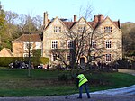 More images |
| Kenricks | Hambleden | House | C19-C20 | 21 June 1955 | SU7867886515 51°34′19″N 0°51′58″W / 51.572024°N 0.86614°W / 51.572024; -0.86614 (Kenricks) | 1160069 | More images |
| Church of St Michael and All Angels | Hughenden Park, Hughenden | Parish Church | 14th century | 21 June 1955 | SU8642195526 51°39′07″N 0°45′08″W / 51.651893°N 0.752224°W / 51.651893; -0.752224 (Church of St Michael and All Angels) | 1125743 | 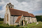 More images |
| Church of St Nicholas | Ibstone | Parish Church | 12th century | 21 June 1955 | SU7560292336 51°37′29″N 0°54′33″W / 51.624773°N 0.909263°W / 51.624773; -0.909263 (Church of St Nicholas) | 1160705 | 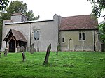 More images |
| Windmill | Lacey Green | Smock Mill | mid-late 17th century | 26 April 1985 | SP8191600781 51°41′59″N 0°48′58″W / 51.699806°N 0.816095°W / 51.699806; -0.816095 (Windmill) | 1159021 | 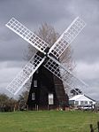 More images |
| Church of St John the Baptist | Little Marlow | Parish Church | Late 12th century | 21 June 1955 | SU8740787826 51°34′57″N 0°44′24″W / 51.582525°N 0.739894°W / 51.582525; -0.739894 (Church of St John the Baptist) | 1311079 | 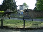 More images |
| Bank Farmhouse | Meadle, Longwick-cum-Ilmer | House | 15th century | 26 April 1985 | SP8068005980 51°44′48″N 0°49′58″W / 51.74672°N 0.832773°W / 51.74672; -0.832773 (Bank Farmhouse) | 1159190 | Upload Photo |
| Church of St Michael and All Angels | Horsenden, Longwick-cum-Ilmer | Parish Church | 15th century | 21 June 1955 | SP7935502922 51°43′10″N 0°51′10″W / 51.719419°N 0.852657°W / 51.719419; -0.852657 (Church of St Michael and All Angels) | 1332032 | 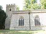 More images |
| Church of St Peter | Ilmer, Longwick-cum-Ilmer | Parish Church | 12th century | 21 June 1955 | SP7692205487 51°44′34″N 0°53′14″W / 51.742816°N 0.887304°W / 51.742816; -0.887304 (Church of St Peter) | 1332033 | 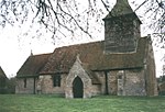 More images |
| Sir William Borlase's Grammar School | Marlow | School | 1624 | 16 July 1949 | SU8454286412 51°34′13″N 0°46′54″W / 51.570251°N 0.781572°W / 51.570251; -0.781572 (Sir William Borlase's Grammar School) | 1217598 | 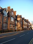 More images |
| Brampton House | Marlow | House | 18th century | 16 July 1949 | SU8502686320 51°34′10″N 0°46′29″W / 51.569351°N 0.774613°W / 51.569351; -0.774613 (Brampton House) | 1332409 | 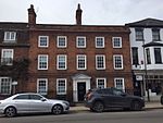 More images |
| Church of All Saints | Marlow | Parish Church | 1832-1835 | 16 July 1949 | SU8513886173 51°34′05″N 0°46′23″W / 51.568013°N 0.773033°W / 51.568013; -0.773033 (Church of All Saints) | 1332380 |  More images |
| Court Garden | Marlow | Country House | 18th century | 31 January 1974 | SU8488386148 51°34′04″N 0°46′36″W / 51.567826°N 0.776717°W / 51.567826; -0.776717 (Court Garden) | 1125078 | 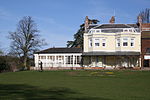 More images |
| Crown Hotel | Marlow | Town Hall/Hotel/Shops | 1807 | 16 July 1949 | SU8483786614 51°34′19″N 0°46′38″W / 51.572022°N 0.777268°W / 51.572022; -0.777268 (Crown Hotel) | 1159570 |  More images |
| Old Parsonage | Marlow | House | 14th century | 16 July 1949 | SU8515386368 51°34′11″N 0°46′22″W / 51.569763°N 0.772769°W / 51.569763; -0.772769 (Old Parsonage) | 1125080 | 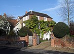 |
| Remnantz | Marlow | House | 1799-1811 | 16 July 1949 | SU8462686402 51°34′13″N 0°46′49″W / 51.570148°N 0.780363°W / 51.570148; -0.780363 (Remnantz) | 1275651 | 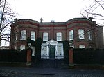 More images |
| The Stables at Remnantz | Marlow | Gate Pier | 16 July 1949 | SU8466386382 51°34′12″N 0°46′47″W / 51.569963°N 0.779834°W / 51.569963; -0.779834 (The Stables at Remnantz) | 1275653 |  | |
| The End House | Marlow | House | Late 18th century | 16 July 1949 | SU8503286310 51°34′09″N 0°46′28″W / 51.56926°N 0.774529°W / 51.56926; -0.774529 (The End House) | 1125072 |  More images |
| The Old House | Marlow | House | 18th century | 16 July 1949 | SU8479586509 51°34′16″N 0°46′40″W / 51.571085°N 0.7779°W / 51.571085; -0.7779 (The Old House) | 1235001 |  |
| The Old Malt House | Marlow | House | Late 18th century | 16 July 1949 | SU8518386234 51°34′07″N 0°46′21″W / 51.568554°N 0.772369°W / 51.568554; -0.772369 (The Old Malt House) | 1275958 | Upload Photo |
| The White House | Marlow | House | c. 1730 | 16 July 1949 | SU8496886411 51°34′13″N 0°46′32″W / 51.570178°N 0.775428°W / 51.570178; -0.775428 (The White House) | 1159481 |  More images |
| Western House | Marlow | House | 1699 | 16 July 1949 | SU8447786355 51°34′11″N 0°46′57″W / 51.569748°N 0.782524°W / 51.569748; -0.782524 (Western House) | 1216983 | Upload Photo |
| 29 and 31 West Street | Marlow | House | 18th century | 16 July 1949 | SU8478686501 51°34′16″N 0°46′41″W / 51.571014°N 0.778031°W / 51.571014; -0.778031 (29 and 31 West Street) | 1235047 | 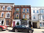 |
| 33 West Street | Marlow | House | 18th century | 16 July 1949 | SU8478186487 51°34′15″N 0°46′41″W / 51.570889°N 0.778107°W / 51.570889; -0.778107 (33 West Street) | 1275805 | Upload Photo |
| 47 West Street | Marlow | House | 18th century | 16 July 1949 | SU8473986462 51°34′14″N 0°46′43″W / 51.570671°N 0.778719°W / 51.570671; -0.778719 (47 West Street) | 1216789 | Upload Photo |
| 41 and 41a High Street | Marlow | House | 18th century | 17 August 1970 | SU8496686471 51°34′15″N 0°46′32″W / 51.570717°N 0.775442°W / 51.570717; -0.775442 (41 and 41a High Street) | 1332404 |  More images |
| 74 and 76 High Street | Marlow | House | Mid 18th century | 16 July 1949 | SU8498086393 51°34′12″N 0°46′31″W / 51.570014°N 0.775259°W / 51.570014; -0.775259 (74 and 76 High Street) | 1332408 | 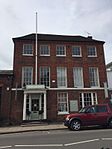 More images |
| Church of St Peter and St Paul | Medmenham | Parish Church | Mid 12th century | 21 June 1955 | SU8047484472 51°33′12″N 0°50′27″W / 51.553405°N 0.840698°W / 51.553405; -0.840698 (Church of St Peter and St Paul) | 1310930 |  More images |
| Danesfield House | Danesfield, Medmenham | Country House | 1899-1901 | 9 August 1977 | SU8163084394 51°33′09″N 0°49′27″W / 51.552538°N 0.824047°W / 51.552538; -0.824047 (Danesfield House) | 1310810 | 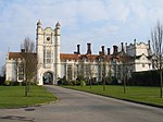 More images |
| Lodge Farmhouse | Medmenham | Farmhouse | 17th century | 21 June 1955 | SU8042384622 51°33′17″N 0°50′29″W / 51.554761°N 0.841399°W / 51.554761; -0.841399 (Lodge Farmhouse) | 1125591 | Upload Photo |
| Medmenham Abbey, Abbey House and Wall with Arch to Forecourt | Medmenham | Abbey | 1987 | 21 June 1955 | SU8068183826 51°32′51″N 0°50′16″W / 51.547569°N 0.837861°W / 51.547569; -0.837861 (Medmenham Abbey, Abbey House and Wall with Arch to Forecourt) | 1310928 | Upload Photo |
| Wittingdon | Wittington, Medmenham | Country House | 1898 | 24 November 1976 | SU8209584414 51°33′10″N 0°49′02″W / 51.552651°N 0.817337°W / 51.552651; -0.817337 (Wittingdon) | 1125557 |  More images |
| Chipps Manor | Wheeler End, Piddington and Wheeler End | Farmhouse | 1733 | 21 June 1955 | SU8032293738 51°38′12″N 0°50′27″W / 51.636724°N 0.840772°W / 51.636724; -0.840772 (Chipps Manor) | 1332101 | Upload Photo |
| Church of St Mary | Princes Risborough | Parish Church | 13th century | 21 June 1955 | SP8059703492 51°43′28″N 0°50′04″W / 51.724366°N 0.834551°W / 51.724366; -0.834551 (Church of St Mary) | 1125815 | 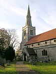 More images |
| Dovecote West of St Dunstan's Church | Monks Risborough, Princes Risborough | Dovecote | 16th century | 21 June 1955 | SP8119204442 51°43′58″N 0°49′33″W / 51.73282°N 0.825717°W / 51.73282; -0.825717 (Dovecote West of St Dunstan's Church) | 1125788 | 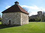 More images |
| Manor House and attached Garden Walls (north West Wall incorporated into the Forge and the Coach House) | Princes Risborough, Wycombe | House | 1955 | 21 June 1955 | SP8061603536 51°43′29″N 0°50′03″W / 51.724759°N 0.834265°W / 51.724759; -0.834265 (Manor House and attached Garden Walls (north West Wall incorporated into the Forge and the Coach House)) | 1311048 |  More images |
| Market House | Princes Risborough | Market House | 1824 | 21 June 1955 | SP8074203502 51°43′28″N 0°49′57″W / 51.724435°N 0.832449°W / 51.724435; -0.832449 (Market House) | 1159718 | 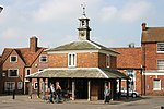 More images |
| Church of St Peter and St Paul | Stokenchurch | Parish Church | 12th century | 21 June 1955 | SU7602996436 51°39′42″N 0°54′08″W / 51.661573°N 0.902206°W / 51.661573; -0.902206 (Church of St Peter and St Paul) | 1310455 |  More images |
| Church of St Mary | Turville | Parish Church | 12th century | 21 June 1955 | SU7670191153 51°36′50″N 0°53′37″W / 51.61399°N 0.893649°W / 51.61399; -0.893649 (Church of St Mary) | 1125644 | 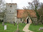 More images |
| Northend Farmhouse | Turville | Farmhouse | c. 1700 | 21 June 1955 | SU7344792744 51°37′43″N 0°56′25″W / 51.628726°N 0.940302°W / 51.628726; -0.940302 (Northend Farmhouse) | 1125674 | Upload Photo |
| The Old Vicarage | Turville | House | c. 1967 | 21 June 1955 | SU7665491165 51°36′51″N 0°53′40″W / 51.614104°N 0.894325°W / 51.614104; -0.894325 (The Old Vicarage) | 1125643 | 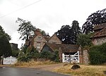 More images |
| Daphne's Temple, West Wycombe Park | West Wycombe | Temple | 18th century | 9 January 1954 | SU8329994644 51°38′40″N 0°47′51″W / 51.644435°N 0.79755°W / 51.644435; -0.79755 (Daphne's Temple, West Wycombe Park) | 1160546 |  More images |
| Flora's Temple, West Wycombe Park | West Wycombe | Loggia | Late 18th century | 9 January 1954 | SU8380494329 51°38′30″N 0°47′25″W / 51.641529°N 0.790329°W / 51.641529; -0.790329 (Flora's Temple, West Wycombe Park) | 1125121 | Upload Photo |
| Island Temple, West Wycombe Park | West Wycombe | Loggia | 1778-1780 | 9 January 1954 | SU8316294451 51°38′34″N 0°47′58″W / 51.642721°N 0.799575°W / 51.642721; -0.799575 (Island Temple, West Wycombe Park) | 1125125 | 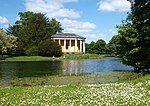 More images |
| North Lodge, West Wycombe Park | West Wycombe | Lodge | 18th century | 9 January 1954 | SU8333894641 51°38′40″N 0°47′49″W / 51.644403°N 0.796987°W / 51.644403; -0.796987 (North Lodge, West Wycombe Park) | 1125126 |  |
| North West Lodge and Gatepiers, West Wycombe Park | West Wycombe | Gate Pier | 18th century | 9 January 1954 | SU8277294647 51°38′40″N 0°48′19″W / 51.64454°N 0.805164°W / 51.64454; -0.805164 (North West Lodge and Gatepiers, West Wycombe Park) | 1125127 | Upload Photo |
| Sawmill House | West Wycombe | House | Late 18th century | 9 January 1954 | SU8373694141 51°38′23″N 0°47′29″W / 51.639849°N 0.791356°W / 51.639849; -0.791356 (Sawmill House) | 1332394 | Upload Photo |
| Small Temple, West Wycombe Park | West Wycombe | Dovecote | Later | 9 January 1954 | SU8284494261 51°38′28″N 0°48′15″W / 51.64106°N 0.804215°W / 51.64106; -0.804215 (Small Temple, West Wycombe Park) | 1125124 | 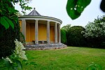 More images |
| Temple of Bacchus, West Wycombe Park | West Wycombe | Statue | 18th century | 28 June 1973 | SU8288594302 51°38′29″N 0°48′13″W / 51.641422°N 0.803613°W / 51.641422; -0.803613 (Temple of Bacchus, West Wycombe Park) | 1125084 | Upload Photo |
| Temple of the Four Winds, West Wycombe Park | West Wycombe | Temple | 18th century | 9 January 1954 | SU8318894170 51°38′25″N 0°47′57″W / 51.640191°N 0.799266°W / 51.640191; -0.799266 (Temple of the Four Winds, West Wycombe Park) | 1160544 | 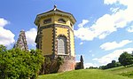 More images |
| The Exedra, West Wycombe Park | West Wycombe | Wall | Late 18th century | 28 June 1973 | SU8289294288 51°38′29″N 0°48′13″W / 51.641295°N 0.803515°W / 51.641295; -0.803515 (The Exedra, West Wycombe Park) | 1125083 | 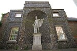 More images |
| Triumphal (Cockpit) Arch, West Wycombe Park | West Wycombe | Arch | Late 18th century | 28 June 1973 | SU8290094288 51°38′29″N 0°48′12″W / 51.641294°N 0.803399°W / 51.641294; -0.803399 (Triumphal (Cockpit) Arch, West Wycombe Park) | 1160549 | 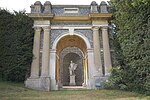 |
| The (Hellfire) Cave | West Wycombe | Cave | 1750-1752 | 9 January 1954 | SU8294294812 51°38′46″N 0°48′10″W / 51.645998°N 0.802668°W / 51.645998; -0.802668 (The (Hellfire) Cave) | 1332393 | 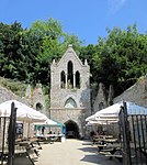 More images |
| The Church Loft | West Wycombe | Guest House | Early 18th century | 9 January 1954 | SU8301594675 51°38′41″N 0°48′06″W / 51.644756°N 0.801646°W / 51.644756; -0.801646 (The Church Loft) | 1125134 | 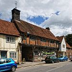 More images |
| The Dower House | West Wycombe | House | c. 1763 | 9 January 1954 | SU8302794698 51°38′42″N 0°48′05″W / 51.644961°N 0.801467°W / 51.644961; -0.801467 (The Dower House) | 1160483 | Upload Photo |
| The Manor House | West Wycombe | House | Early 18th century | 9 January 1954 | SU8298794675 51°38′41″N 0°48′07″W / 51.64476°N 0.802051°W / 51.64476; -0.802051 (The Manor House) | 1125135 | Upload Photo |
| Workshop (furniture Factory) adjoining No 37 High Street on North and occupied by EMF Brown | West Wycombe | Furniture Factory | Late 18th century or early 19th century | 9 January 1954 | SU8302194686 51°38′41″N 0°48′06″W / 51.644854°N 0.801557°W / 51.644854; -0.801557 (Workshop (furniture Factory) adjoining No 37 High Street on North and occupied by EMF Brown) | 1125174 | Upload Photo |
| Church of St Paul | Wooburn | Parish Church | Late 12th century | 21 June 1955 | SU9095387795 51°34′54″N 0°41′19″W / 51.581686°N 0.688738°W / 51.581686; -0.688738 (Church of St Paul) | 1125542 | 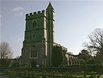 More images |
| Clapton Revel | Wooburn | House | c1700-1710 | 17 October 1969 | SU9100290035 51°36′07″N 0°41′15″W / 51.601813°N 0.687451°W / 51.601813; -0.687451 (Clapton Revel) | 1125541 | Upload Photo |
| Cores End Cottage, Cores End House | Wooburn | House | c. 1730 | 21 June 1955 | SU9041987249 51°34′37″N 0°41′48″W / 51.576864°N 0.696583°W / 51.576864; -0.696583 (Cores End Cottage, Cores End House) | 1160086 | Upload Photo |
| Bassetsbury Manor | Wycombe | Manor House | Late 17th century or early 18th century | 9 January 1954 | SU8765492378 51°37′24″N 0°44′07″W / 51.623405°N 0.735194°W / 51.623405; -0.735194 (Bassetsbury Manor) | 1310947 |  More images |
| Church of Saint Francis | Wycombe | Church | 1929-1930 | 28 June 1973 | SU8771994485 51°38′32″N 0°44′01″W / 51.642335°N 0.733728°W / 51.642335; -0.733728 (Church of Saint Francis) | 1125114 |  More images |
| Disraeli Monument | Wycombe | Wall | 1862 | 28 June 1973 | SU8565594619 51°38′38″N 0°45′49″W / 51.643857°N 0.763515°W / 51.643857; -0.763515 (Disraeli Monument) | 1125201 |  More images |
| Hughenden Manor Farmhouse | Wycombe | Farmhouse | Late 17th century or early 18th century | 9 January 1954 | SU8575395117 51°38′54″N 0°45′43″W / 51.648319°N 0.761977°W / 51.648319; -0.761977 (Hughenden Manor Farmhouse) | 1125184 | Upload Photo |
| Premises occupied by Midland Bank | Wycombe | Bank (financial) | 18th century | 9 January 1954 | SU8653992996 51°37′45″N 0°45′04″W / 51.629133°N 0.751144°W / 51.629133; -0.751144 (Premises occupied by Midland Bank) | 1125187 | Upload Photo |
| The Little Market House | Wycombe | Market House | c. 1604 | 9 January 1954 | SU8655693031 51°37′46″N 0°45′03″W / 51.629445°N 0.750889°W / 51.629445; -0.750889 (The Little Market House) | 1310836 | 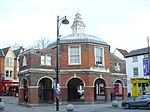 More images |
| Wycombe Abbey (parts of Wycombe Abbey School) | Wycombe | Manor House | 17th century | 9 January 1954 | SU8658192627 51°37′33″N 0°45′02″W / 51.625809°N 0.750628°W / 51.625809; -0.750628 (Wycombe Abbey (parts of Wycombe Abbey School)) | 1310649 | Upload Photo |
| 7 Castle Street | Wycombe | House | 18th century | 28 June 1973 | SU8656293129 51°37′49″N 0°45′03″W / 51.630325°N 0.750779°W / 51.630325; -0.750779 (7 Castle Street) | 1159695 | Upload Photo |
| 30 High Street | Wycombe | House | 18th century | 9 January 1954 | SU8666792924 51°37′42″N 0°44′58″W / 51.628466°N 0.749313°W / 51.628466; -0.749313 (30 High Street) | 1159966 | Upload Photo |
| 33 High Street | Wycombe | House | 18th century | 9 January 1954 | SU8664292942 51°37′43″N 0°44′59″W / 51.628632°N 0.749669°W / 51.628632; -0.749669 (33 High Street) | 1332337 | Upload Photo |
| 34 High Street | Wycombe | House | 18th century or earlier | 28 June 1973 | SU8662492942 51°37′43″N 0°45′00″W / 51.628634°N 0.749929°W / 51.628634; -0.749929 (34 High Street) | 1125162 | Upload Photo |
| 39 High Street | Wycombe | Town House | 1st half of 18th century | 9 January 1954 | SU8657192981 51°37′44″N 0°45′02″W / 51.628993°N 0.750685°W / 51.628993; -0.750685 (39 High Street) | 1125163 | Upload Photo |
Notes
- ^ The date given is the date used by Historic England as significant for the initial building or that of an important part in the structure's description.
- ^ Sometimes known as OSGB36, the grid reference is based on the British national grid reference system used by the Ordnance Survey.
- ^ The "List Entry Number" is a unique number assigned to each listed building and scheduled monument by Historic England.
External links
- v
- t
- e
- Bedfordshire
- Berkshire
- Bristol
- Buckinghamshire
- Cambridgeshire
- Cheshire
- Cornwall
- Cumbria
- Derbyshire
- Devon
- Dorset
- Durham
- East Sussex
- East Riding of Yorkshire
- Essex
- Gloucestershire
- Greater London
- Greater Manchester
- Hampshire
- Herefordshire
- Hertfordshire
- Isle of Wight
- Kent
- Lancashire
- Leicestershire
- Lincolnshire
- Merseyside
- Norfolk
- North Yorkshire
- Northamptonshire
- Northumberland
- Nottinghamshire
- Oxfordshire
- Rutland
- Shropshire
- Somerset
- South Yorkshire
- Staffordshire
- Suffolk
- Surrey
- Tyne and Wear
- Warwickshire
- West Midlands
- West Sussex
- West Yorkshire
- Wiltshire
- Worcestershire
- Allerdale
- Amber Valley
- Ashford
- Babergh
- Barrow-in-Furness
- Basildon
- Basingstoke and Deane
- Bath and North East Somerset
- Bolsover
- Boston
- Bournemouth
- Bradford
- Braintree
- Breckland
- Brentwood
- Brighton and Hove
- Bristol
- Broadland
- Calderdale
- Cambridge
- Camden
- Canterbury
- Carlisle
- Castle Point
- Chelmsford
- Cheltenham
- Cherwell
- Cheshire East
- Cheshire West and Chester
- Chesterfield
- Chiltern
- Christchurch
- Colchester
- Copeland
- Corby
- Cotswold
- Dartford
- Daventry
- Dover
- East Cambridgeshire
- Exeter
- Mendip
- North Somerset
- North Yorkshire (district)
- Poole
- Sedgemoor
- South Somerset
- Stoke-on-Trent
- Taunton Deane
- West Somerset
- York


