Guaymango
You can help expand this article with text translated from the corresponding article in Spanish. (June 2023) Click [show] for important translation instructions.
- Machine translation, like DeepL or Google Translate, is a useful starting point for translations, but translators must revise errors as necessary and confirm that the translation is accurate, rather than simply copy-pasting machine-translated text into the English Wikipedia.
- Do not translate text that appears unreliable or low-quality. If possible, verify the text with references provided in the foreign-language article.
- You must provide copyright attribution in the edit summary accompanying your translation by providing an interlanguage link to the source of your translation. A model attribution edit summary is
Content in this edit is translated from the existing Spanish Wikipedia article at [[:es:Guaymango]]; see its history for attribution. - You may also add the template
{{Translated|es|Guaymango}}to the talk page. - For more guidance, see Wikipedia:Translation.
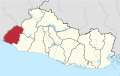
Municipality in Ahuachapán Department, El Salvador
13°45′N 89°50′W / 13.750°N 89.833°W / 13.750; -89.833 El Salvador
 (2006)
Guaymango is a municipality in the Ahuachapán department of El Salvador.
External links
![]() Media related to Guaymango at Wikimedia Commons
Media related to Guaymango at Wikimedia Commons
- v
- t
- e

Capital: Ahuachapán
- Ahuachapán
- Apaneca
- Atiquizaya
- Concepción de Ataco
- El Refugio
- Guaymango
- Jujutla
- San Francisco Menéndez
- San Lorenzo
- San Pedro Puxtla
- Tacuba
- Turín
- Banderas River
- Cara Sucia River
- El Imposible National Park
- Paz River
 | This El Salvador location article is a stub. You can help Wikipedia by expanding it. |
- v
- t
- e


