Holm of Sandwick
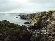
The Holm of Sandwick is an islet, located roughly 100 metres (330 ft) off Haa Ness and the southwestern side of Whalsay, in the Shetland Islands of Scotland. The small groups of islets to the west are called the Flaeshans of Sandwick. To the southwest is Sava Skerry. It is reported that a ship named Griften of unknown nationality was shipwrecked either here or on Rumble Holm in 1611.[1]
References
- ^ Old-lore Miscellany of Orkney, Shetland, Caitness and Sutherland. Viking Club. 1907. p. 123. Retrieved 5 February 2013.
Wikimedia Commons has media related to Holm of Sandwick.
60°19′46″N 1°01′32″W / 60.329422°N 1.025532°W / 60.329422; -1.025532
- v
- t
- e
Whalsay
- Brough
- Challister
- Clate
- Hamister
- Huxter
- Isbister
- Marrister
- New Park
- North Park
- Saltness
- Sandwick
- Skaw
- Sodom
- Symbister
- Treawick
- Tripwell
- Vaivoe
- Vats-houll

- Bays, cliffs, and headlands: List of coastal features of Whalsay
- Linga Sound
- Islets: East Linga
- Holm of Sandwick
- Inner Holm of Skaw
- Isbister Holm
- Mooa
- Nista
- Outer Holm of Skaw
- Rumble
- Skate of Marrister
- West Linga
- Hills: Setter Hill
- Lochs: Little Water
- Loch of Houll
- Loch of Huxter
- Loch of Isbister
- Loch of Livister
- Loch of Sandwick
- Loch of Stanefield
- Loch of Vats-houll
- Nuckro Water
- East Loch of Skaw
- West Loch of Skaw
- Streams: Breiwick Burn
- Falsa Burn
- Scarfmoor Burn
 | This Shetland location article is a stub. You can help Wikipedia by expanding it. |
- v
- t
- e


