Imperial College Road
Tree-lined road in South Kensington, London, England
 Imperial College Road from Exhibition Road | |
| Former name(s) | Imperial Institute Road[1] |
|---|---|
| Namesake | Imperial College London |
| Location | Albertopolis, Westminster, London, United Kingdom |
| Postal code | SW7 |
| Nearest Tube station |  South Kensington (east end) Gloucester Road (west end) South Kensington (east end) Gloucester Road (west end) |
| Coordinates | 51°29′53″N 0°10′36″W / 51.49806°N 0.17667°W / 51.49806; -0.17667 |
| West end | Falmouth Gate, Queen's Gate |
| East end | Exhibition Road |
| Other | |
| Known for | Queen's Tower, Imperial College London (historically Imperial Institute, Royal College of Science) |
Imperial College Road is a tree-lined road in South Kensington, London, England.[2][3] It runs east–west with Queen's Gate to the west and Exhibition Road to the east.
The road forms part of the boundary between Royal Borough of Kensington and Chelsea to the south and the City of Westminster to the north. It lies at the heart of the area known as Albertopolis, with a number of museums, cultural buildings and educational institutions in the area, a legacy of the Great Exhibition of 1851 held in Hyde Park to the north and promoted by Prince Albert, husband of Queen Victoria. Formerly known as Imperial Institute Road, the road now takes its name from Imperial College London, on whose campus it is located.[2] The Queen's Tower (surrounded by the Queen's Lawn adjacent to Imperial College Road) dominates the view to the north halfway along the road, along with the college's main library. To the south are the Department of Chemistry of Imperial College, the Sir Alexander Fleming Building, and the Science Museum. Beyond these buildings is the Natural History Museum.
-
 Aerial view from the south. Imperial College Road runs left–right in front of the Queen's Tower in the centre of the view
 -
 Royal College of Science on Imperial Institute Road
 -
 Falmouth Gate looking towards Queen's Gate
 -
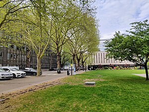 The road runs along Queen's Lawn
 -
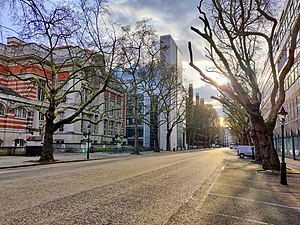 From the corner with Unwin Road looking west
 -
 West end at Queen's Gate looking east


See also
References
- ^ Ordnance Survey. "IV.16 (City Of Westminster; Kensington; Paddington)" (1914). London (1915- Numbered sheets). National Library of Scotland. Retrieved 21 Dec 2019.
- ^ a b "South Kensington Campus" (PDF). UK: Imperial College London. Archived from the original (PDF) on 9 November 2015. Retrieved 21 September 2015.
- ^ "Imperial College Road". LondonTown.com. Retrieved 21 September 2015.
- v
- t
- e

- Chelsea and Fulham
- Kensington
and streets
- Alexander Square
- Brompton Road
- Brompton Square
- Cadogan Square
- Carlyle Square
- Cromwell Road
- Edwardes Square
- Flood Street
- Hans Place
- Kensington High Street
- Kensington Square
- King's Road
- Ladbroke Square
- Lowndes Square (save E. side)
- Notting Hill Gate
- Onslow Square
- Pavilion Road
- Pembroke Square
- Powis Square
- Redcliffe Square
- Sloane Square
- Sloane Street
- Thurloe Square
- Victoria Road
railway stations

- Anglesea Arms
- Bunch of Grapes
- Chelsea Potter
- The Churchill Arms
- Coleherne
- The Cross Keys
- Drayton Arms
- Elgin
- Fox and Pheasant
- Gloucester Arms
- The Goat
- The Greyhound
- The Hansom Cab
- Hollywood Arms
- The King's Head and Eight Bells
- The Phene
- Prince of Teck
- Scarsdale Tavern
- The Shuckburgh Arms
- Windsor Castle
- The World's End
- Zetland Arms
- former
- Blue plaques
- Council
- Listed buildings
- Parks and open spaces
- Parks Police
- People
- Public art
- Schools
- Grenfell Tower and related fire
 Category
 Commons

Imperial College London | |||||||||||
|---|---|---|---|---|---|---|---|---|---|---|---|
| Academics |
|  | |||||||||
||
| Affiliates | |||||||||||
| |||||||||||
 | This article relating to Imperial College London is a stub. You can help Wikipedia by expanding it. |
- v
- t
- e
 | This London road or road transport-related article is a stub. You can help Wikipedia by expanding it. |
- v
- t
- e


