Inishkeel
Irish monastery
54°50′51″N 8°27′22″W / 54.84750°N 8.45611°W / 54.84750; -8.45611
Ireland
Inishkeel (Irish: Inis Caoil)[3] is a small tidal island and a townland[1] off the coast of County Donegal, Ireland. The closest village on the mainland is Narin.
Geography
The island is located in Gweebarra Bay around 250 m from the coast. A sandy tidal bank connects, with low tide, the island with the mainland.[3]
History
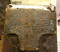
During the 6th century A.D. a small community of monks settled on the island. Their religious leader was Saint Conall Cael, from whom the island later derived its name. During the following centuries Inishkeel was a traditional destination of pilgrimages. Remains of the church and the connected buildings as well as some carved stones can be seen on the island.[4] For its artistical and archeological importance the island was declared National Monument (code: DG064-003).[5] A bell known as St Conall Cael's Bell remained on Inishkeel up to the 19th century and was then acquired by the British Museum.[6]
Demography
A small community used to live on Inishkeel in the past, and in year 1841 23 inhabitants were registered on the island.[7] The island was later abandoned and in 2011 census had no inhabitants.[2]
References

- ^ a b "Inishkeel Townland, Co. Donegal". www.townlands.ie. Cóipcheart Townlands.ie. Retrieved 9 May 2016.
- ^ a b Population (Number) by Off Shore Island, Year and Sex Central Statistics Office
- ^ a b Liam Ronayne (2000). Donegal: South of the Gap. Dundurn. ISBN 9781900935159. Retrieved 9 May 2016.
- ^ "Inishkeel Monastic Site". www.megalithicireland.com. Retrieved 9 May 2016.
- ^ National Monuments in State Care: Ownership & Guardianship (PDF). National Monuments Service / Seirbhís na Séadcomharthaí Náisiúnta. 2009. Retrieved 19 April 2021.
- ^ Rowena Loverance (2007). Christian Art. Harvard University Press. ISBN 9780674024793. Retrieved 9 May 2016.
- ^ Commissioners 4th Rpt, p.15 Newport West E Division
See also
![]() Media related to Inishkeel at Wikimedia Commons
Media related to Inishkeel at Wikimedia Commons
 Ireland portal
 Islands portal


- v
- t
- e
Places in County Donegal
County town: Lifford

- Annagry
- Ardara
- Ballindrait
- Ballintra
- Ballyliffin
- Bridgend
- Bruckless
- Burnfoot
- Burtonport
- Carrick
- Carrigans
- Carrigart
- Churchill
- Cloghan
- Clonmany
- Convoy
- Cranford
- Creeslough
- Crolly
- Culdaff
- Doochary
- Downings
- Drumkeen
- Dunfanaghy
- Dunkineely
- Dunlewey
- Fahan
- Fintown
- Frosses
- Glen
- Glencolmcille
- Greencastle
- Inver
- Kerrykeel
- Kilcar
- Killea
- Killygordon
- Kilmacrennan
- Laghy
- Leabgarrow
- Lettermacaward
- Loughanure
- Malin
- Malin Beg
- Manorcunningham
- Meenlaragh
- Milford
- Mountcharles
- Moville
- Muff
- Narin
- Newtowncunningham
- Pettigo
- Porthall
- Portnablagh
- Quigley's Point
- Raphoe
- Rathmullan
- Redcastle
- Rossnowlagh
- Shrove
- St Johnston
- Teelin
- Termon
- List of townlands in County Donegal
- Category:Mountains and hills of County Donegal
- Category:Rivers of County Donegal
- Category:Geography of County Donegal


