Kiviõli
Town in Estonia
Town in Ida-Viru County, Estonia
59°21′N 26°58′E / 59.350°N 26.967°E / 59.350; 26.967 Estonia
 Ida-Viru County
 Lüganuse Parish
 (2021)[1]
Kiviõli is an industrial town in Ida-Viru County, Estonia, established in 1922. The main industry in the town is oil shale mining, which gives the town its name (literally 'stone oil').
History
In 1922, the joint-stock company Eesti Kiviõli (i.e., 'Estonian stone oil') established an oil shale quarry in land belonging to the village of Salaküla, and mining commenced in 1930. A worker's settlement belonging to the village of Varinurme was built in the 1930s and named Kiviõli after the joint-stock company. Kiviõli became a town in 1946.[2]
Demographics
| Ethnicity | 1959[3] | 1970[4] | 1979[5] | 1989[5] | 2000[6] | 2011[7] | 2021[8] | |||||||
|---|---|---|---|---|---|---|---|---|---|---|---|---|---|---|
| amount | % | amount | % | amount | % | amount | % | amount | % | amount | % | amount | % | |
| Estonians | 6017 | 57.6 | 5789 | 51.9 | 4914 | 44.5 | 3958 | 38.1 | 2921 | 39.5 | 2179 | 38.7 | 1924 | 39.6 |
| Russians | - | - | 4431 | 39.7 | 5184 | 47.0 | 5369 | 51.7 | 3793 | 51.2 | 3020 | 53.6 | 2498 | 51.5 |
| Ukrainians | - | - | 152 | 1.36 | 228 | 2.06 | 308 | 2.96 | 157 | 2.12 | 109 | 1.93 | 136 | 2.80 |
| Belarusians | - | - | 93 | 0.83 | 139 | 1.26 | 184 | 1.77 | 119 | 1.61 | 79 | 1.40 | 69 | 1.42 |
| Finns | - | - | 368 | 3.30 | 348 | 3.15 | 308 | 2.96 | 193 | 2.61 | 100 | 1.77 | 68 | 1.40 |
| Jews | - | - | 13 | 0.12 | 11 | 0.10 | 10 | 0.10 | 3 | 0.04 | 2 | 0.04 | 0 | 0.00 |
| Latvians | - | - | 41 | 0.37 | 25 | 0.23 | 19 | 0.18 | 10 | 0.14 | 10 | 0.18 | 10 | 0.21 |
| Germans | - | - | - | - | 74 | 0.67 | 83 | 0.80 | 46 | 0.62 | 49 | 0.87 | 31 | 0.64 |
| Tatars | - | - | - | - | 13 | 0.12 | 26 | 0.25 | 14 | 0.19 | 7 | 0.12 | 6 | 0.12 |
| Poles | - | - | - | - | 26 | 0.24 | 22 | 0.21 | 11 | 0.15 | 7 | 0.12 | 7 | 0.14 |
| Lithuanians | - | - | 18 | 0.16 | 27 | 0.24 | 24 | 0.25 | 17 | 0.23 | 14 | 0.25 | 12 | 0.25 |
| unknown | 0 | 0.00 | 0 | 0.00 | 0 | 0.00 | 0 | 0.00 | 70 | 0.94 | 4 | 0.07 | 5 | 0.10 |
| other | 4427 | 42.4 | 248 | 2.22 | 61 | 0.55 | 79 | 0.76 | 51 | 0.69 | 54 | 0.96 | 86 | 1.77 |
| Total | 10444 | 100 | 11153 | 100 | 11050 | 100 | 10390 | 100 | 7405 | 100 | 5634 | 100 | 4854 | 99.9 |
Neighborhoods of Kiviõli
Included in the town limits, but somewhat separate from the main part of the town, are the districts of Küttejõu and Varinurme.
There are five neighborhoods of Kiviõli:
- Küttejõu
- Lepatee
- Sala-Aru
- Soopealse
- Varinurme.[9]
Gallery
-
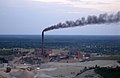 Kiviõli oil factory
 -

-

-
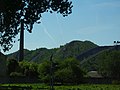 Ash mountains


See also
References
- ^ "Population by sex, age group and place of residence after the 2017 administrative reform, 1 January". Statistics Estonia. Retrieved 26 December 2021.
- ^ "Kiviõli". Dictionary of Estonian Place Names. Tallinn: Eesti Keele Instituut. Retrieved 15 February 2024.
- ^ Katus, Kalev; Puur, Allan; Põldma, Asta (2002). Rahvastiku ühtlusarvutatud sündmus- ja loendusstatistika: Ida-Virumaa 1965-1990. Sari C (in Estonian and English). Tallinn: Eesti Kõrgkoolidevaheline Demouuringute Keskus. pp. 31–32. ISBN 9985-820-66-5.
- ^ Население районов, городов и поселков городского типа Эстонской ССР : по данным Всесоюзной переписи населения на 15 января 1970 года. Таллинн, 1972.
- ^ a b Eesti Vabariigi maakondade, linnade ja alevite rahvastik: 1989. a. rahvaloenduse andmed: statistikakogumik. 1. osa: Rahvaarv rahvuse, perekonnaseisu, hariduse ja elatusallikate järgi. Tallinn: Statistikaamet. 1990. pp. 28, 33. ISBN 978-9949-71-932-7.
- ^ "RL222: RAHVASTIK ELUKOHA JA RAHVUSE JÄRGI". Estonian Statistical Database (in Estonian).
- ^ "RL0429: RAHVASTIK RAHVUSE, SOO, VANUSERÜHMA JA ELUKOHA JÄRGI, 31. DETSEMBER 2011". Estonian Statistical Database (in Estonian).
- ^ "RL21429: RAHVASTIK RAHVUSE, SOO, VANUSERÜHMA JA ELUKOHA (HALDUSÜKSUS) JÄRGI, 31. DETSEMBER 2021". Estonian Statistical Database (in Estonian).
- ^ "LINNAOSADE JA -JAGUDE LÜHENDID". eki.ee (in Estonian). Retrieved 18 March 2020.
External links
Wikimedia Commons has media related to Kiviõli.
- v
- t
- e
- Abja-Paluoja
- Antsla
- Elva
- Haapsalu
- Jõgeva
- Jõhvi
- Kallaste
- Kärdla
- Karksi-Nuia
- Kehra
- Keila
- Kilingi-Nõmme
- Kiviõli
- Kohtla-Järve
- Kunda
- Kuressaare
- Lihula
- Loksa
- Maardu
- Mõisaküla
- Mustvee
- Narva
- Narva-Jõesuu
- Otepää
- Paide
- Paldiski
- Pärnu
- Põltsamaa
- Põlva
- Püssi
- Rakvere
- Räpina
- Rapla
- Saue
- Sillamäe
- Sindi
- Suure-Jaani
- Tallinn
- Tamsalu
- Tapa
- Tartu
- Tõrva
- Türi
- Valga
- Viljandi
- Võhma
- Võru

Jaanilinn (Ivangorod) and Petseri (Pechory) were annexed by the Soviet Union in 1945 and are currently part of Russia.
| ||
|---|---|---|
| Town |
|  |
| Small borough | ||
| Villages |
| |
Authority control databases | |
|---|---|
| International |
|
| Geographic |
|
59°21′N 26°58′E / 59.350°N 26.967°E / 59.350; 26.967
 | This Estonia location article is a stub. You can help Wikipedia by expanding it. |
- v
- t
- e


