Lake Menomin
Reservoir in northwestern Wisconsin
44°53′02″N 091°55′45″W / 44.88389°N 91.92917°W / 44.88389; -91.92917Lake Menomin is a reservoir on the Red Cedar River, in Dunn County, Wisconsin, USA.[2] Its name is derived from the Ojibwe name for this lake, Manoominikaani-zaaga'igan meaning "Abundant with Wild Rice Lake."
Along the lake's western and southern shores lies the city of Menomonie, the central business district of which is located at the far southern end of the lake, near the dam which forms it. There are multiple public parks, trails, beaches, and boat landings along the lake's shoreline. Common fish found in lake Menomin include Panfish, Largemouth and Smallmouth Bass, Northern Pike, and Walleye.[3] Throughout the summer, blue-green algae blooms afflict the lake due to high nutrient levels.
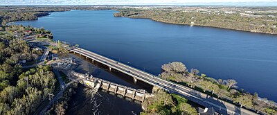
The Tainter gate was invented for use with the reservoir's 1886 dam.[4]
References
- ^ "Lake Menomin". Geographic Names Information System. United States Geological Survey, United States Department of the Interior. January 2018. Retrieved January 16, 2021.
- ^ Hiking Trails, Mountain Bike Trails & Trail Maps | Trails.com
- ^ "Lake Menomin". dnr.wi.gov. Retrieved 2019-07-01.
- ^ "The Tainter Gate". Dunn County Historical Society.
External links
- Wolske Bay Association
- v
- t
- e
 | This article related to a lake in the United States is a stub. You can help Wikipedia by expanding it. |
- v
- t
- e


