List of Category A listed buildings in West Dunbartonshire

Map all coordinates using OpenStreetMap
Download coordinates as:
- KML
- GPX (all coordinates)
- GPX (primary coordinates)
- GPX (secondary coordinates)
This is a list of Category A listed buildings in the West Dunbartonshire council area in central Scotland.
In Scotland, the term listed building refers to a building or other structure officially designated as being of "special architectural or historic interest".[1] Category A structures are those considered to be "buildings of national or international importance, either architectural or historic, or fine little-altered examples of some particular period, style or building type."[2] Listing was begun by a provision in the Town and Country Planning (Scotland) Act 1947, and the current legislative basis for listing is the Planning (Listed Buildings and Conservation Areas) (Scotland) Act 1997.[3] The authority for listing rests with Historic Scotland, an executive agency of the Scottish Government, which inherited this role from the Scottish Development Department in 1991. Once listed, severe restrictions are imposed on the modifications allowed to a building's structure or its fittings. Listed building consent must be obtained from local authorities prior to any alteration to such a structure.[3] There are approximately 47,400 listed buildings in Scotland, of which around 8% (some 3,800) are Category A.[4]
The council area of West Dunbartonshire covers 159 square kilometres (61 sq mi), and has a population of around 90,900. There are 20 Category A listed buildings in the area.
Listed buildings
| Name | Location | Date Listed | Grid Ref. [note 1] | Geo-coordinates | Notes | LB Number [note 2] | Image |
|---|---|---|---|---|---|---|---|
| Strathleven House | Vale of Leven | NS3960878118 | 55°58′09″N 4°34′17″W / 55.96919°N 4.571491°W / 55.96919; -4.571491 (Strathleven House) | [5] | 115 | 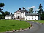 Upload another image | |
| Balloch Castle | Balloch | NS3902983024 | 56°00′47″N 4°35′01″W / 56.01303°N 4.583694°W / 56.01303; -4.583694 (Balloch Castle) | [6] | 123 | 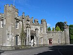 Upload another image | |
| Argyll Motor Works | Alexandria, North Main Street | NS3893380676 | 55°59′31″N 4°35′02″W / 55.991923°N 4.583825°W / 55.991923; -4.583825 (Argyll Motor Works) | [7] | 127 |  Upload another image | |
| Dovecot, Strathleven House | Vale of Leven | NS3968578170 | 55°58′11″N 4°34′13″W / 55.969682°N 4.570289°W / 55.969682; -4.570289 (Dovecot, Strathleven House) | [8] | 823 |  Upload another image | |
| Woodbank House (Hamilton House Hotel) | Balloch, Luss Road | NS3818881758 | 56°00′05″N 4°35′47″W / 56.001384°N 4.596407°W / 56.001384; -4.596407 (Woodbank House (Hamilton House Hotel)) | [9] | 1125 |  Upload another image | |
| Alexandria Masonic Temple | Alexandria, Gilmour Street | NS3882980135 | 55°59′13″N 4°35′07″W / 55.987033°N 4.585166°W / 55.987033; -4.585166 (Alexandria Masonic Temple) | [10] | 1135 |  Upload another image | |
| Smollett Monument | Renton, Main Street | NS3881078200 | 55°58′11″N 4°35′04″W / 55.969659°N 4.584311°W / 55.969659; -4.584311 (Smollett Monument) | [11] | 1168 | 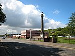 Upload another image | |
| Millburn Church | Renton, Main Street | NS3879278916 | 55°58′34″N 4°35′06″W / 55.976079°N 4.585028°W / 55.976079; -4.585028 (Millburn Church) | [12] | 1176 |  Upload another image | |
| Ross Priory | Gartocharn | NS4146187566 | 56°03′17″N 4°32′51″W / 56.054609°N 4.547412°W / 56.054609; -4.547412 (Ross Priory) | [13] | 7625 |  Upload another image | |
| Titan Cantilever Crane | Clydebank, former John Brown & Company shipyard | NS4948569758 | 55°53′50″N 4°24′31″W / 55.897342°N 4.408734°W / 55.897342; -4.408734 (Titan Cantilever Crane) | [14] | 22993 |  Upload another image | |
| Ship Model Experiment Tank | Dumbarton, Castle Street | NS4003775207 | 55°56′36″N 4°33′46″W / 55.943205°N 4.562896°W / 55.943205; -4.562896 (Ship Model Experiment Tank) | [15] | 24873 |  Upload another image | |
| Former Dumbarton Academy | Dumbarton, Church Street | NS3980475285 | 55°56′38″N 4°34′00″W / 55.943827°N 4.566669°W / 55.943827; -4.566669 (Former Dumbarton Academy) | [16] | 24874 |  Upload another image | |
| Dumbarton Central Station | Dumbarton, Station Road | NS3975875601 | 55°56′48″N 4°34′03″W / 55.946648°N 4.567593°W / 55.946648; -4.567593 (Dumbarton Central Station) | [17] | 24877 | 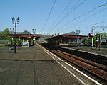 Upload another image | |
| Dumbarton Castle | Dumbarton | NS3998874485 | 55°56′12″N 4°33′48″W / 55.936708°N 4.563252°W / 55.936708; -4.563252 (Dumbarton Castle) | [18] | 24880 |  Upload another image | |
| Dumbarton Riverside Parish Church | Dumbarton, High Street | NS3976975186 | 55°56′35″N 4°34′02″W / 55.942927°N 4.56717°W / 55.942927; -4.56717 (Dumbarton Riverside Parish Church) | [19] | 24885 |  Upload another image | |
| St Augustine's Episcopal Church | Dumbarton, High Street | NS3969075254 | 55°56′37″N 4°34′07″W / 55.943511°N 4.568474°W / 55.943511; -4.568474 (St Augustine's Episcopal Church) | [20] | 24890 | 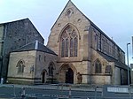 Upload another image | |
| Overtoun House | Milton | NS4245976127 | 55°57′08″N 4°31′29″W / 55.952263°N 4.524696°W / 55.952263; -4.524696 (Overtoun House) | [21] | 24907 |  Upload another image | |
| Levenford House | Dumbarton, Helenslee Road | NS3903175410 | 55°56′41″N 4°34′45″W / 55.944691°N 4.579107°W / 55.944691; -4.579107 (Levenford House) | [22] | 24916 | 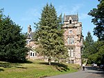 Upload another image | |
| Dalmoak House | Renton | NS3835677071 | 55°57′34″N 4°35′27″W / 55.959373°N 4.5909°W / 55.959373; -4.5909 (Dalmoak House) | [23] | 45600 | 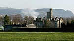 Upload another image | |
| Drumkinnon Bay, Winch House and Slipway | Balloch Pier, Loch Lomond | NS3855482457 | 56°00′28″N 4°35′27″W / 56.007781°N 4.590964°W / 56.007781; -4.590964 (Drumkinnon Bay, Winch House and Slipway) | [24] | 46721 | 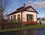 Upload another image |
Notes
- ^ Sometimes known as OSGB36, the grid reference (where provided) is based on the British national grid reference system used by the Ordnance Survey.
• "Guide to National Grid". Ordnance Survey. Retrieved 12 December 2007.
• "Get-a-map". Ordnance Survey. Retrieved 17 December 2007. - ^ Historic Environment Scotland assign a unique alphanumeric identifier to each designated site in Scotland, for listed buildings this always begins with "LB", for example "LB12345".
References
- ^ Guide to the Protection of Scotland's Listed Buildings (PDF). Historic Scotland. 2009. p. 4. ISBN 978-1-84917-013-0. Retrieved 5 May 2010.
- ^ "What is Listing?". Historic Scotland. Retrieved 5 May 2010.
- ^ a b Scottish Historic Environment Policy (PDF). Historic Scotland. October 2008. pp. 24–25. ISBN 978-1-84917-002-4. Retrieved 5 May 2010.
- ^ Guide to the Protection of Scotland’s Listed Buildings, p. 17.
- ^ "Strathleven House: Listed Building Report". Historic Scotland.
- ^ "Balloch Castle: Listed Building Report". Historic Scotland.
- ^ "Alexandria, North Main Street, Argyll Motor Works With Lodge, Gatepiers, Railings And Boundary Wall: Listed Building Report". Historic Scotland.
- ^ "Dovecot, Strathleven: Listed Building Report". Historic Scotland.
- ^ "Woodbank House With Garden Building: Listed Building Report". Historic Scotland.
- ^ "Alexandria, Gilmour Street, Masonic Temple: Listed Building Report". Historic Scotland.
- ^ "Renton, Main Street, Smollett Monument: Listed Building Report". Historic Scotland.
- ^ "Renton, Main Street, Millburn Church, Former Free Church With Boundary Wall, Gravestones, Railings And Gatepiers: Listed Building Report". Historic Scotland.
- ^ "Ross Priory: Listed Building Report". Historic Scotland.
- ^ "Clydebank, Former John Brown Shipbuilding Yard Titan Cantilever Crane: Listed Building Report". Historic Scotland.
- ^ "Castle Street, Ship Model Experiment Tank (British Shipbuilders - Formerly Vickers Ltd): Listed Building Report". Historic Scotland.
- ^ "Church Street, Sseb Education Offices (Former Academy): Listed Building Report". Historic Scotland.
- ^ "Church Street, Dumbarton Central Station: Listed Building Report". Historic Scotland.
- ^ "Dumbarton Castle: Listed Building Report". Historic Scotland.
- ^ "High Street, Dumbarton Riverside Parish Church, Cemetery Walls And Gateways: Listed Building Report". Historic Scotland.
- ^ "High Street St Augustine's Episcopal Church: Listed Building Report". Historic Scotland.
- ^ "Overtoun House And Garden Walls: Listed Building Report". Historic Scotland.
- ^ "West Bridgend, Levenford House: Listed Building Report". Historic Scotland.
- ^ "Renton, Dalmoak House: Listed Building Report". Historic Scotland.
- ^ "Loch Lomond, Drumkinnon Bay, Winch House Including Slipway: Listed Building Report". Historic Scotland.
External links
![]() Media related to Category A listed buildings in West Dunbartonshire at Wikimedia Commons
Media related to Category A listed buildings in West Dunbartonshire at Wikimedia Commons
- v
- t
- e
- City of Aberdeen
- Aberdeenshire
- Angus
- Argyll and Bute
- Clackmannanshire
- Dumfries and Galloway
- City of Dundee
- East Ayrshire
- East Dunbartonshire
- East Lothian
- East Renfrewshire
- City of Edinburgh
- Falkirk
- Fife
- City of Glasgow
- Highland
- Inverclyde
- Midlothian
- Moray
- North Ayrshire
- North Lanarkshire
- Orkney
- Perth and Kinross
- Renfrewshire
- Scottish Borders
- Shetland
- South Ayrshire
- South Lanarkshire
- Stirling
- West Dunbartonshire
- West Lothian
- Western Isles (na h-Eileanan Siar)


