List of crossings of the Willamette River
Map all coordinates using OpenStreetMap
Download coordinates as:
- KML
- GPX (all coordinates)
- GPX (primary coordinates)
- GPX (secondary coordinates)

This is a list of bridges and other crossings of the Willamette River in the U.S. state of Oregon from the Columbia River upstream to the confluence of the Middle Fork Willamette River and Coast Fork Willamette River. This confluence, at 44°01′24″N 123°01′26″W / 44.023318°N 123.023897°W / 44.023318; -123.023897 (Willamette River source), is considered the source of the Willamette River.
Sauvie Island
| Image | Crossing | Carries | Location | River mile | Year built | Coordinates |
|---|---|---|---|---|---|---|
 | Sauvie Island Bridge | Sauvie Island Road, sidewalks | Sauvie Island | 3 | 2008 | 45°37′41″N 122°48′59″W / 45.628021°N 122.816307°W / 45.628021; -122.816307 |
Portland
| Image | Crossing | Carries | Location | River mile | Year built | Coordinates |
|---|---|---|---|---|---|---|
 | St. Johns Bridge |   US 30 Byp., sidewalks US 30 Byp., sidewalks | Portland | 5.8 | 1931 | 45°35′07″N 122°45′52″W / 45.58528°N 122.76444°W / 45.58528; -122.76444 (St. Johns Bridge) |
 | Burlington Northern Railroad Bridge 5.1 | BNSF Railway | Portland | 7.0 | 1908/1989 | 45°34′36″N 122°44′51″W / 45.57667°N 122.74750°W / 45.57667; -122.74750 (Burlington Northern Railroad Bridge 5.1) |
| West Side CSO Tunnel | intercepted sewage overflow | Portland | 10.0 | 2003 | 45°33′0″N 122°41′52″W / 45.55000°N 122.69778°W / 45.55000; -122.69778 (West Side CSO Tunnel) | |
 | Fremont Bridge |  I-405 / US 30 I-405 / US 30 | Portland | 11.1 | 1973 | 45°32′16″N 122°40′59″W / 45.53778°N 122.68306°W / 45.53778; -122.68306 (Fremont Bridge) |
 | Broadway Bridge | Broadway; Portland Streetcar; sidewalks | Portland | 11.7 | 1913 | 45°31′55″N 122°40′27″W / 45.53194°N 122.67417°W / 45.53194; -122.67417 (Broadway Bridge) |
 | Steel Bridge | Union Pacific Railway Amtrak MAX Light Rail Glisan Street, sidewalks, Interstate Avenue Eastbank Esplanade (lower level), formerly Harbor Drive (former  OR 99W) OR 99W) | Portland | 12.1 | 1912 | 45°31′39″N 122°40′09″W / 45.52750°N 122.66917°W / 45.52750; -122.66917 (Steel Bridge) |
 | Burnside Bridge | Burnside Street, sidewalks | Portland | 12.4 | 1926 | 45°31′23″N 122°40′03″W / 45.52306°N 122.66750°W / 45.52306; -122.66750 (Burnside Bridge) |
 | Morrison Bridge | Morrison Street, sidewalks | Portland | 12.8 | 1958 | 45°31′04″N 122°40′11″W / 45.51778°N 122.66972°W / 45.51778; -122.66972 (Morrison Bridge) |
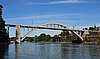
 | Hawthorne Bridge | Hawthorne Boulevard, sidewalks | Portland | 13.1 | 1910 | 45°30′47″N 122°40′14″W / 45.51306°N 122.67056°W / 45.51306; -122.67056 (Hawthorne Bridge) |
 | Marquam Bridge |  I-5 I-5 | Portland | 13.5 | 1966 | 45°30′29″N 122°40′09″W / 45.50806°N 122.66917°W / 45.50806; -122.66917 (Marquam Bridge) |
 | Tilikum Crossing | TriMet MAX Orange Line and buses, Portland Streetcar, cycle lane, sidewalks | Portland | 13.8 | 2015 | 45°30′18″N 122°40′01″W / 45.5049°N 122.6670°W / 45.5049; -122.6670 (Tilikum Crossing) |
 | Ross Island Bridge |  US 26 (Powell Boulevard), sidewalks US 26 (Powell Boulevard), sidewalks | Portland | 14.0 | 1926 | 45°30′04″N 122°39′52″W / 45.50111°N 122.66444°W / 45.50111; -122.66444 (Ross Island Bridge) |
 | Sellwood Bridge | Tacoma Street, sidewalks | Portland | 16.5 | 2016 | 45°27′52″N 122°39′56″W / 45.46444°N 122.66556°W / 45.46444; -122.66556 (Sellwood Bridge) |
Northern Willamette Valley
| Image | Crossing | Carries | Location | River mile | Year built | Coordinates |
|---|---|---|---|---|---|---|
 | Lake Oswego Railroad Bridge | Portland and Western Railroad | Lake Oswego/Milwaukie | 20.0 | 1910 | 45°25′30″N 122°39′17″W / 45.42500°N 122.65472°W / 45.42500; -122.65472 (Lake Oswego Railroad Bridge) |
 | Abernethy Bridge |  I-205 I-205 | Oregon City | 25.0 | 1970 | 45°21′52″N 122°36′15″W / 45.36444°N 122.60417°W / 45.36444; -122.60417 (Abernethy Bridge) |
 | Oregon City Bridge |  OR 43, sidewalks OR 43, sidewalks | Oregon City | 26.0 | 1922 | 45°21′32″N 122°36′35″W / 45.35889°N 122.60972°W / 45.35889; -122.60972 (Oregon City Bridge) |
| 2 sets of aerial electric cable crossings | West Linn/Canby | 30.0 | 45°19′04″N 122°39′57″W / 45.31774°N 122.66585°W / 45.31774; -122.66585 (2 sets of aerial electric cable crossings) | |||
| 115 kV-line | Canby | 45°17′57″N 122°41′31″W / 45.299083°N 122.692012°W / 45.299083; -122.692012 (115 kV-line) | ||||
| aerial electric power for the Canby Ferry | Canby | 34.37 | 45°18′00″N 122°41′31″W / 45.30009°N 122.69192°W / 45.30009; -122.69192 (aerial electric power for the Canby Ferry) | |||
 | Canby Ferry | SW Mountain Rd (on the north), N Locust St (on the south) | Canby | 34.4 | 1914 | 45°18′00″N 122°41′34″W / 45.30011°N 122.69273°W / 45.30011; -122.69273 (Canby Ferry) |
| aerial electric cable crossing | Molalla River State Park | 35.98 | 45°18′08″N 122°43′19″W / 45.30214°N 122.72207°W / 45.30214; -122.72207 (aerial electric cable crossing) | |||
 | Boone Bridge | I-5 | Wilsonville | 38.5 | 1954 | 45°17′31″N 122°46′10″W / 45.29194°N 122.76944°W / 45.29194; -122.76944 (Boone Bridge) |
 | Wilsonville railroad bridge | (formerly) Oregon Electric Railway (currently) Portland & Western Railroad | Wilsonville | 38.5 | 1907/1975 | 45°17′35″N 122°46′35″W / 45.29306°N 122.77639°W / 45.29306; -122.77639 (rail bridge) |
 | Oregon Route 219 bridge |  OR 219 OR 219 | Newberg | 48.3 | 1958 | 45°16′04″N 122°56′36″W / 45.26778°N 122.94333°W / 45.26778; -122.94333 (Oregon Route 219 bridge) |
 | Champoeg Road bridge | Pipeline (Prior to 1958, carried OR 219, between the north ends of Riverside Road and Champoeg Road in Marion County and the south end of Wynooski Street in Newberg. Replaced an earlier ferry between Champoeg Road and the south end of Dog Ridge Road, about 1,200 feet (370 meters) west of the current highway bridge.) | Newberg | 50.0 | 45°17′02″N 122°57′44″W / 45.28377°N 122.96222°W / 45.28377; -122.96222 (Champoeg Road bridge) |
Middle Willamette Valley
| Image | Crossing | Carries | Location | River mile | Year built | Coordinates |
|---|---|---|---|---|---|---|
 | Wheatland Ferry | Wheatland Road | Wheatland | 72.0 | 1844 | 45°05′25″N 123°02′42″W / 45.09028°N 123.04500°W / 45.09028; -123.04500 (Wheatland Ferry) |
| aerial electric power for the Wheatland Ferry | Wheatland | 45°05′24.28″N 123°02′43.61″W / 45.0900778°N 123.0454472°W / 45.0900778; -123.0454472 (aerial electric power for the Wheatland Ferry) | ||||
| medium voltage line | Wheatland | 45°05′27.02″N 123°02′41.56″W / 45.0908389°N 123.0448778°W / 45.0908389; -123.0448778 (medium voltage line) | ||||
 | Union Street Railroad Bridge | (formerly) Black Rock Rail Line, (currently) pedestrians, bicycles, emergency vehicles | Salem | 84.1 | 1913 | 44°56′50″N 123°02′30″W / 44.94722°N 123.04167°W / 44.94722; -123.04167 (Union Street Railroad Bridge) |
 | Marion Street Bridge |   OR 22 west (Marion Street) OR 22 west (Marion Street) | Salem | 84.4 | 1952 | 44°56′45″N 123°02′33″W / 44.94583°N 123.04250°W / 44.94583; -123.04250 (Marion Street Bridge) |
 | Center Street Bridge |  OR 22 east (Center Street) OR 22 east (Center Street) | Salem | 84.5 | 1918 | 44°56′42″N 123°02′36″W / 44.94500°N 123.04333°W / 44.94500; -123.04333 (Center Street Bridge) |
| Independence Street Bridge | River Road South, sidewalks | Independence | 97.1 | 1950 | 44°50′44″N 123°10′47″W / 44.84556°N 123.17972°W / 44.84556; -123.17972 (Independence Street Bridge) | |
 | Buena Vista Ferry | Buena Vista Road | Buena Vista | 106.0 | 1851 | 44°46′12″N 123°08′45″W / 44.77000°N 123.14583°W / 44.77000; -123.14583 (Buena Vista Ferry) |
| aerial electric power for the Buena Vista Ferry | Buena Vista | 44°46′11.37″N 123°08′46.23″W / 44.7698250°N 123.1461750°W / 44.7698250; -123.1461750 (aerial electric power for the Buena Vista Ferry) | ||||
 | Toledo District Willamette Bridge | (formerly) Oregon Pacific Railroad, Southern Pacific (currently) Portland and Western Railroad/Toledo District | Albany | 119.7 | 1887/1921 | 44°38′27″N 123°05′48″W / 44.64085°N 123.09677°W / 44.64085; -123.09677 (Toledo District Willamette Bridge) |
| Lyon Street Bridge |   US 20 north (Lyon Street), sidewalk US 20 north (Lyon Street), sidewalk | Albany | 120.0 | 1971 | 44°38′21″N 123°06′21″W / 44.63917°N 123.10587°W / 44.63917; -123.10587 (Lyon Street Bridge) | |
 | Ellsworth Street Bridge |  US 20 south (Ellsworth Street), sidewalks US 20 south (Ellsworth Street), sidewalks | Albany | 120.1 | 1925 | 44°38′21″N 123°06′24″W / 44.63924°N 123.10666°W / 44.63924; -123.10666 (Ellsworth Street Bridge) |
 | Harrison Street Bridge |  OR 34 west (Harrison Street), bicycle lane, sidewalk OR 34 west (Harrison Street), bicycle lane, sidewalk | Corvallis | 131.5 | 1964 | 44°33′58″N 123°15′22″W / 44.5661°N 123.25622°W / 44.5661; -123.25622 (Harrison Street Bridge) |
 | Van Buren Street Bridge | OR 34 east (Van Buren Street), sidewalk | Corvallis | 131.5 | 1913 | 44°33′55″N 123°15′23″W / 44.56541°N 123.25652°W / 44.56541; -123.25652 (Van Buren Street Bridge) |
 | Corvallis Bypass Bridge | OR 34 Bypass | Corvallis | 132.95 | 1992 | 44°33′29″N 123°15′36″W / 44.55814°N 123.25987°W / 44.55814; -123.25987 (Corvallis Bypass Bridge) |
Southern Willamette Valley
| Image | Crossing | Carries | Location | River mile | Year built | Coordinates |
|---|---|---|---|---|---|---|
| OR 99E bridge |  OR 99E, sidewalk OR 99E, sidewalk | Harrisburg | 161.2 | 1925 | 44°16′01″N 123°10′29″W / 44.26708°N 123.17483°W / 44.26708; -123.17483 (Oregon Route 99E bridge) | |
| Oregon Electric rail bridge; former vertical-lift type, now fixed in place | (formerly) Oregon Electric Railway, Burlington Northern (currently) Portland and Western Railroad | Junction City | 162.7 | 1912 | 44°14′55″N 123°10′31″W / 44.24864°N 123.17538°W / 44.24864; -123.17538 (rail bridge) | |
| (Oregon and California Railroad) Southern Pacific rail bridge; former swing-span type, now concrete-steel truss bridge | (formerly) Southern Pacific (currently) Union Pacific Railroad Amtrak | Junction City | 162.8 | 1871/1905/2014 | 44°14′53″N 123°10′28″W / 44.24815°N 123.17451°W / 44.24815; -123.17451 (rail bridge) | |
| Beltline Highway (westbound), sidewalk |  OR 569 west OR 569 west | Eugene | 178.2 | 1961 | 44°05′43″N 123°06′23″W / 44.09525°N 123.10651°W / 44.09525; -123.10651 (Beltline Highway (westbound)) | |
| Beltline Highway (eastbound) | OR 569 east | Eugene | 178.2 | 1966 | 44°05′43″N 123°06′24″W / 44.09519°N 123.10666°W / 44.09519; -123.10666 (Beltline Highway (eastbound)) | |
 | Owosso Bicycle Bridge | Eugene | 178.7 | 44°05′31″N 123°06′58″W / 44.09185°N 123.11609°W / 44.09185; -123.11609 (Owosso Bicycle Bridge) | ||
 | Greenway Bicycle Bridge | Eugene | 180.6 | 1978 | 44°04′03″N 123°06′42″W / 44.06750°N 123.11175°W / 44.06750; -123.11175 (Greenway Bicycle Bridge) | |
| Washington-Jefferson Street Bridge |   I-105 / OR 126 I-105 / OR 126 | Eugene | 181.2 | 1960 | 44°03′50″N 123°06′03″W / 44.06391°N 123.10076°W / 44.06391; -123.10076 (Washington-Jefferson Street Bridge) | |
 | Ferry Street Bridge | Coburg Road Ruth Bascom Bike Path | Eugene | 182.2 | 1950 | 44°03′29″N 123°05′02″W / 44.05794°N 123.08391°W / 44.05794; -123.08391 (Ferry Street Bridge) |
 | Peter DeFazio Bicycle Bridge | Eugene | 182.35 | 2000 | 44°03′25″N 123°05′01″W / 44.05691°N 123.08352°W / 44.05691; -123.08352 (Peter DeFazio Bicycle Bridge) | |
 | Dave and Lynn Frohnmayer Pedestrian and Bicycle Bridge[1] | Eugene | 182.7 | 1970 | 44°03′06″N 123°04′17″W / 44.05160°N 123.07127°W / 44.05160; -123.07127 (Dave and Lynn Frohnmayer Pedestrian and Bicycle Bridge) | |
| Knickerbocker Bicycle Bridge | Eugene | 183.8 | 1978 | 44°02′43″N 123°03′08″W / 44.04529°N 123.05214°W / 44.04529; -123.05214 (Knickerbocker Bicycle Bridge) | ||
 | Whilamut Passage Bridge (west span) |  I-5 south I-5 south | Eugene | 183.91 | 2011 | 44°02′43″N 123°03′00″W / 44.04540°N 123.05010°W / 44.04540; -123.05010 (Whilamut Passage Bridge) |
 | Whilamut Passage Bridge (east span) |  I-5 north I-5 north | Eugene | 183.92 | 2013[2] | 44°02′44″N 123°02′58″W / 44.04550°N 123.04958°W / 44.04550; -123.04958 (Whilamut Passage Bridge) |
 | Springfield Bridge (north span) |  OR 126 Bus. west (Main Street), sidewalks OR 126 Bus. west (Main Street), sidewalks | Springfield | 185.25 | 1950 | 44°02′44″N 123°01′39″W / 44.04544°N 123.02743°W / 44.04544; -123.02743 (Springfield Bridge (north span)) |
 | Springfield Bridge (south span) | OR 126 Bus. east (South "A" Street), sidewalk | Springfield | 185.3 | 44°02′42″N 123°01′38″W / 44.04511°N 123.02718°W / 44.04511; -123.02718 (Springfield Bridge (south span)) | |
 | Springfield Southern Pacific Rail bridge | Union Pacific Railroad Amtrak | Springfield | 185.4 | 1906/1926 | 44°02′35″N 123°01′34″W / 44.04308°N 123.02615°W / 44.04308; -123.02615 (Southern Pacific Rail bridge) |
Former crossings
| Image | Crossing | Carried | Location | River mile | Year built | Coordinates |
|---|---|---|---|---|---|---|
| "First" Steel Bridge (until 1912) | OR&N Railway | Portland | 12.0 | 1888 | ||
 | Madison Street Bridge[n 1] | Madison Street | Portland | 13.1 | 1891, 1900[n 1] | 45°30′48″N 122°40′15″W / 45.51333°N 122.67083°W / 45.51333; -122.67083 (former Madison Street Bridge) |
 | Boones Ferry | Boones Ferry Road | Wilsonville | 38.9 | 1847 | 45°17′35″N 122°46′30″W / 45.29312°N 122.775038°W / 45.29312; -122.775038 (Boones Ferry (1847–1959)) |
| Springfield PE&E Streetcar Bridge (until 1926) | Portland, Eugene and Eastern Streetcar | Springfield | 185.3 | 1910 |
See also
- Course of the Willamette River
- List of bridges in Portland, Oregon
- List of crossings of the Columbia River
- Lists of Oregon-related topics
Notes
- ^ a b Two former bridges over the Willamette River in Portland were named the Madison Street Bridge. Together, they were active from 1891 to 1909.[3][4]
References
- ^ Edward Russo (September 15, 2009). "Popular river crossing renamed". The Register-Guard. Eugene, Oregon. p. B1.
- ^ "Whilamut Passage Bridge Opens". KEZI.com. August 8, 2013. Archived from the original on September 30, 2013. Retrieved November 30, 2014.
- ^ "Hawthorne Bridge: Spanning Willamette River on Hawthorne Boulevard, Portland, Multnomah County, Oregon" (PDF). Historic American Engineering Record, National Park Service, United States Department of the Interior. p. 2. Archived (PDF) from the original on March 5, 2016. Retrieved August 18, 2016.
- ^ "Old Span Wrecked; Madison Bridge in Six Weeks Will Be Only Memory". The Morning Oregonian. August 2, 1909. p. 14. Archived from the original on September 16, 2016. Retrieved August 18, 2016.
External links
- Event data as RDF [dead link]
Portals:
 Engineering
 Oregon
 Transport


