List of historic places in Northern Region, Manitoba
Map all coordinates using OpenStreetMap
Download coordinates as:
- KML
- GPX (all coordinates)
- GPX (primary coordinates)
- GPX (secondary coordinates)
This is a list of historic places in Northern Region, Manitoba, entered on the Canadian Register of Historic Places, whether they are federal, provincial, or municipal.
List of historic places
| Name | Address | Coordinates | Government recognition (CRHP №) | Image | |
|---|---|---|---|---|---|
| Depot | York Factory MB | 57°02′37″N 92°14′53″W / 57.0437°N 92.248°W / 57.0437; -92.248 (Depot) | Federal (2969) |  | |
| Air Terminal Building H-7 | Churchill Airport Churchill MB | 58°44′14″N 94°03′22″W / 58.7372°N 94.0562°W / 58.7372; -94.0562 (Air Terminal Building H-7) | Federal (9709) |  | |
| Canadian Imperial Bank of Commerce Building | 464 Sherritt Avenue Lynn Lake MB | 58°51′05″N 101°02′42″W / 58.8515°N 101.045°W / 58.8515; -101.045 (Canadian Imperial Bank of Commerce Building) | Lynn Lake municipality (17142) |  Upload Photo | |
| York Factory National Historic Site of Canada | York Factory MB | 57°02′42″N 92°14′55″W / 57.0449°N 92.2485°W / 57.0449; -92.2485 (York Factory National Historic Site of Canada) | Federal (4481) |  More images | |
| Via Rail - Canadian National Railway Station | 1st Street & Railway Ave. Churchill MB | 58°46′08″N 94°10′23″W / 58.769°N 94.173°W / 58.769; -94.173 (Via Rail - Canadian National Railway Station (Churchill)) | Federal (6727, (9525) | 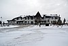 | |
| Prince of Wales Fort National Historic Site of Canada | Eskimo Point MB | 58°47′36″N 94°12′43″W / 58.7932°N 94.2119°W / 58.7932; -94.2119 (Prince of Wales Fort National Historic Site of Canada) | Federal (7760) |  More images | |
| Sea Horse Gully Remains National Historic Site of Canada | West Peninsula of Churchill River opposite town of Churchill Churchill MB | 58°46′36″N 94°14′43″W / 58.7766°N 94.2454°W / 58.7766; -94.2454 (Sea Horse Gully Remains National Historic Site of Canada) | Federal (18791) | Upload Photo | |
| Flin Flon Museum | Flin Flon MB | 54°46′14″N 101°50′24″W / 54.7706°N 101.8399°W / 54.7706; -101.8399 (Flin Flon Museum) | Federal (20246) | Upload Photo | |
| Norway House National Historic Site of Canada | Norway House MB | 53°59′19″N 97°49′08″W / 53.9886°N 97.819°W / 53.9886; -97.819 (Norway House National Historic Site of Canada) | Federal (12041) |  | |
| Churchill Rocket Research Range National Historic Site of Canada | Churchill MB | 58°46′39″N 93°43′07″W / 58.7774°N 93.7185°W / 58.7774; -93.7185 (Churchill Rocket Research Range National Historic Site of Canada) | Federal (12776) |  | |
| St. Paul's Anglican Church | 67 Bernier Street Churchill MB | 58°46′13″N 94°10′13″W / 58.7704°N 94.1704°W / 58.7704; -94.1704 (St. Paul's Anglican Church) | Manitoba (17141) |  | |
| Archway Warehouse, Jail and Powder Magazine Remains | Norway House 17 Norway House MB | 53°58′54″N 97°50′11″W / 53.9816°N 97.8365°W / 53.9816; -97.8365 (Archway Warehouse, Jail and Powder Magazine Remains) | Manitoba (15866) | Upload Photo | |
| VIA Rail/Canadian National Railways Station | Railway Avenue Cranberry Portage MB | 54°35′09″N 101°22′56″W / 54.5858°N 101.3822°W / 54.5858; -101.3822 (VIA Rail/Canadian National Railways Station (Cranberry Portage)) | Federal (4548), Cranberry Portage municipality (19930) |  | |
| Crane River Reserve Catholic Church Site | Crane River 51 Crane River MB | 51°30′53″N 99°15′39″W / 51.5147°N 99.2608°W / 51.5147; -99.2608 (Crane River Reserve Catholic Church Site) | Crane River municipality (15147) | Upload Photo | |
| VIA Rail/Canadian National Railways Station | 252 Railway Avenue Gillam MB | 56°20′51″N 94°41′59″W / 56.3474°N 94.6997°W / 56.3474; -94.6997 (VIA Rail/Canadian National Railways Station (Gillam)) | Federal (4548) | Upload Photo | |
| Bank of Commerce Building | 162 Fischer Avenue Kelsey (Carrot Valley) MB | 53°49′08″N 101°14′56″W / 53.8188°N 101.249°W / 53.8188; -101.249 (Bank of Commerce Building) | Kelsey (Carrot Valley) municipality (9313) | Upload Photo | |
| Christ Church | 2 Saskatchewan Crescent, The Pas Kelsey (Carrot Valley) MB | 53°49′38″N 101°15′24″W / 53.8273°N 101.2568°W / 53.8273; -101.2568 (Christ Church) | Kelsey (Carrot Valley) municipality (20245) | Upload Photo | |
| Court House and Community Building | 306 Fischer Avenue Kelsey (Carrot Valley) MB | 53°49′08″N 101°14′56″W / 53.8188°N 101.249°W / 53.8188; -101.249 (Court House and Community Building) | Manitoba (9314) | Upload Photo | |
| Charlebois Chapel | 108 First Street West Kelsey (Carrot Valley) MB | 53°49′17″N 101°14′46″W / 53.8215°N 101.246°W / 53.8215; -101.246 (Charlebois Chapel) | Kelsey (Carrot Valley) municipality (9315) | Upload Photo | |
| Heritage North Museum | 162 Princeton Drive Thompson MB | 55°43′58″N 97°51′18″W / 55.7329°N 97.8551°W / 55.7329; -97.8551 (Heritage North Museum) | Thompson municipality (19368) | Upload Photo | |
| Wanipigow Lake Archaeological Site | Division No. 19 MB | 51°04′40″N 95°54′30″W / 51.0778°N 95.9083°W / 51.0778; -95.9083 (Wanipigow Lake Archaeological Site) | Manitoba (8980) | Upload Photo |
See also
- v
- t
- e
- Asessippi
- Atikaki
- Bakers Narrows
- Beaudry
- Beaver Creek
- Bell Lake
- Birch Island
- Birch Point
- Birds Hill
- Burge Lake
- Camp Morton
- Caribou River
- Chitek Lake Anishinaabe
- Clearwater Lake
- Colvin Lake
- Criddle/Vane Homestead
- Duck Mountain
- Duff Roblin
- Elk Island
- Fisher Bay
- Grand Beach
- Grand Rapids
- Grand Valley
- Grass River
- Hecla-Grindstone
- Hnausa Beach
- Hyland
- Kettle Stones
- Kinwow Bay
- Lake St. Andrew
- Lake St. George
- Little Limestone Lake
- Lockport
- Lundar Beach
- Manigotagan River
- Manipogo
- Marchland
- Margaret Bruce
- Memorial
- Moose Lake
- Neso Lake
- Netley Creek
- Nopiming
- Norris Lake
- North Steeprock Lake
- Nueltin Lake
- Numaykoos Lake
- Oak Lake
- Overflowing River
- Paint Lake
- Patricia Beach
- Pembina Valley
- Pinawa Dam
- Pinawa
- Pisew Falls
- Poplar Bay
- Portage Spillway
- Primrose
- Rainbow Beach
- Red Deer River
- River Road
- Rivers
- Rocky Lake
- Sand Lakes
- Sasagiu Rapids
- Seton
- South Atikaki
- Springwater
- Spruce Woods
- St. Ambroise Beach
- St. Malo
- St. Norbert
- Stephenfield
- Sturgeon Bay
- Swan River
- Trappest Monastery
- Turtle Mountain
- Twin Lakes
- Upper Fort Garry Heritage
- Wallace Lake
- Watchorn
- Wekusko Falls
- Whitefish Lake
- Whitemouth Falls
- Whiteshell
- William Lake
- Winnipeg Beach
- Woodridge
- Yellow Quill
- Zed Lake
- Agassiz
- Belair
- Brightstone Sand Hill
- Cat Hills
- Cormorant
- Duck Mountain
- Moose Creek
- Northwest Angle
- Porcupine
- Sandilands
- Spruce Woods
- Swan-Pelican
- Turtle Mountain
- Wampum
- Whiteshell
- Armit Meadows
- Baralzon Lake
- Birch River
- Brokenhead River
- Brokenhead Wetland
- Cedar Bog
- Cowan Bog
- Holmgren Pines
- Jennifer and Tom Shay
- Kaweenakumik Islands
- Lake St. George Caves
- Lake Winnipegosis Salt Flats
- Lewis Bog
- Libau Bog
- Little George Island
- Long Point
- Palsa Hazel
- Pelican Islands
- Piney
- Pocock Lake
- Red Rock
- Reindeer Island
- Ste. Anne Bog
- St. Labre Bog
- Walter Cook Caves
- Wampum
- Whitemouth Bog
- Whitemouth Island
- Whitemouth River
- Woodridge
- Alonsa
- Assiniboine Corridor
- Basket Lake
- Bernice
- Brandon Hills
- Broad Valley
- Broomhill
- C. Stewart Stevenson
- Catfish Creek
- Cayer
- Churchill
- Delta Marsh
- Deerwood
- Dog Lake
- Ebor
- Gerald W. Malaher
- Grant's Lake
- Gypsumville
- Harrison
- Hilbre
- Holmfield
- Kasatamagan Sipi
- Kasatamagan
- Lake Francis
- Langruth
- Lauder Sandhills
- Lee Lake
- Lee River
- Little Birch
- Little Saskatchewan
- Manatagao
- Maple Lake
- Mars Hill
- Marshy Point
- Moose Creek
- Narcisse
- Oak Hammock Marsh
- Observation Point
- Oranole
- Otter Lake
- Parkland
- Pembina Valley
- Penonan Point
- Pierson
- Point River
- Portage Sandhills
- Proven Lake
- Proulx Lake
- Rat River
- Red Deer
- Riverside
- Saskeram
- Sleeve Lake
- Souris River Bend
- Spruce Woods
- Spur Woods
- St. Malo
- Steeprock
- Stuartburn
- Thalberg Bush
- Tiger Hills
- Tom Lamb
- Turtle Mountain
- Upper Assiniboine
- Wakopa
- Washow Bay
- Watson P. Davidson
- Weiden
- Wellington
- Westlake
- Whitemouth Bog
- Whitemud Watershed
- Whitewater Lake
World Biosphere Reserves
- Assiniboine
- Bruce
- Central
- Kil-Cona
- Kildonan
- King's
- Living Prairie Museum
- Maple Grove
- St. Vital
- Stephen Juba
 Category
- Conservation Districts
- Parks Canada
 Commons


