List of listed buildings in Inverurie, Aberdeenshire
This is a list of listed buildings in the parish of Inverurie in Aberdeenshire, Scotland.
Map all coordinates using OpenStreetMap
Download coordinates as:
- KML
- GPX (all coordinates)
- GPX (primary coordinates)
- GPX (secondary coordinates)
List
| Name | Location | Date Listed | Grid Ref. [note 1] | Geo-coordinates | Notes | LB Number [note 2] | Image |
|---|---|---|---|---|---|---|---|
| West High Street West Parish Church, Including Boundary Walls | 57°17′03″N 2°22′35″W / 57.284182°N 2.376358°W / 57.284182; -2.376358 (West High Street West Parish Church, Including Boundary Walls) | Category B | 45604 |  Upload Photo | |||
| Clydesdale Bank, 1 High Street | 57°16′57″N 2°22′25″W / 57.282618°N 2.373722°W / 57.282618; -2.373722 (Clydesdale Bank, 1 High Street) | Category B | 35393 | Upload Photo | |||
| Nos 1-12 Crosslett Court, Market Place | 57°17′01″N 2°22′25″W / 57.283679°N 2.373566°W / 57.283679; -2.373566 (Nos 1-12 Crosslett Court, Market Place) | Category C(S) | 35400 | Upload Photo | |||
| 100 High Street | 57°16′44″N 2°22′16″W / 57.278853°N 2.371096°W / 57.278853; -2.371096 (100 High Street) | Category B | 35396 | Upload Photo | |||
| 106 High Street | 57°16′42″N 2°22′15″W / 57.278414°N 2.370876°W / 57.278414; -2.370876 (106 High Street) | Category B | 35397 | Upload Photo | |||
| Clydesdale Bank, 26 West High Street And 1 Constitution Street | 57°17′04″N 2°22′36″W / 57.284568°N 2.376677°W / 57.284568; -2.376677 (Clydesdale Bank, 26 West High Street And 1 Constitution Street) | Category B | 35402 | Upload Photo | |||
| Old Sluice Bridges Over Aberdeen Canal, Canal Road | 57°16′25″N 2°22′11″W / 57.27354°N 2.36965°W / 57.27354; -2.36965 (Old Sluice Bridges Over Aberdeen Canal, Canal Road) | Category C(S) | 35408 | Upload Photo | |||
| St. Mary's Episcopal Church, High Street | 57°16′40″N 2°22′11″W / 57.277914°N 2.369743°W / 57.277914; -2.369743 (St. Mary's Episcopal Church, High Street) | Category B | 35398 | Upload Photo | |||
| Inverurie Town Hall, Market Place | 57°16′47″N 2°22′20″W / 57.279667°N 2.372232°W / 57.279667; -2.372232 (Inverurie Town Hall, Market Place) | Category B | 35399 | 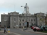 Upload another image | |||
| Old Inverurie Churchyard, (North-Western Part Of Inverurie Cemetery) | 57°16′33″N 2°22′00″W / 57.275902°N 2.366788°W / 57.275902; -2.366788 (Old Inverurie Churchyard, (North-Western Part Of Inverurie Cemetery)) | Category B | 35405 | Upload Photo | |||
| Inverurie Hospital, Nurses' Home | 57°16′35″N 2°22′43″W / 57.276325°N 2.37855°W / 57.276325; -2.37855 (Inverurie Hospital, Nurses' Home) | Category B | 13321 | Upload Photo | |||
| Former Workshop, Former Great North Of Scotland Locomotive Works, Harlaw Road | 57°17′18″N 2°22′44″W / 57.288271°N 2.378806°W / 57.288271; -2.378806 (Former Workshop, Former Great North Of Scotland Locomotive Works, Harlaw Road) | Category B | 49303 | Upload Photo | |||
| St Andrew's Manse And St.Andrew's Cottage, Glebe Road | 57°16′47″N 2°22′40″W / 57.279839°N 2.377856°W / 57.279839; -2.377856 (St Andrew's Manse And St.Andrew's Cottage, Glebe Road) | Category B | 35392 | Upload Photo | |||
| Catholic Church Of The Immaculate Conception, Presbytery House And Out-House. 116 North Street | 57°17′23″N 2°23′13″W / 57.289711°N 2.386833°W / 57.289711; -2.386833 (Catholic Church Of The Immaculate Conception, Presbytery House And Out-House. 116 North Street) | Category B | 35403 | Upload Photo | |||
| Inverurie Hospital, Administration Block | 57°16′36″N 2°22′47″W / 57.276555°N 2.379614°W / 57.276555; -2.379614 (Inverurie Hospital, Administration Block) | Category B | 13320 | Upload Photo | |||
| Manar House | 57°16′09″N 2°26′20″W / 57.269157°N 2.438997°W / 57.269157; -2.438997 (Manar House) | Category B | 9074 | Upload Photo | |||
| 80 High Street | 57°16′47″N 2°22′18″W / 57.279615°N 2.371668°W / 57.279615; -2.371668 (80 High Street) | Category B | 35395 | Upload Photo | |||
| Inverurie Hospital, Gatelodge And Quadrant Walls | 57°16′34″N 2°22′47″W / 57.276168°N 2.379809°W / 57.276168; -2.379809 (Inverurie Hospital, Gatelodge And Quadrant Walls) | Category B | 13322 | Upload Photo | |||
| Manar Home Farm | 57°16′17″N 2°25′48″W / 57.271263°N 2.430135°W / 57.271263; -2.430135 (Manar Home Farm) | Category B | 9075 | Upload Photo | |||
| Manar Dovecot Manar Policies | 57°16′11″N 2°26′20″W / 57.269858°N 2.438973°W / 57.269858; -2.438973 (Manar Dovecot Manar Policies) | Category B | 9077 | Upload Photo | |||
| Parish Church Of St. Andrew, High Street, (Excluding Halls) | 57°16′48″N 2°22′23″W / 57.280078°N 2.372983°W / 57.280078; -2.372983 (Parish Church Of St. Andrew, High Street, (Excluding Halls)) | Category B | 35391 | Upload Photo | |||
| 123 North Street | 57°17′24″N 2°23′18″W / 57.290029°N 2.388463°W / 57.290029; -2.388463 (123 North Street) | Category B | 35404 | Upload Photo | |||
| Inverurie Hospital, Double House Fronting Upperboat Road | 57°16′36″N 2°22′49″W / 57.27658°N 2.380278°W / 57.27658; -2.380278 (Inverurie Hospital, Double House Fronting Upperboat Road) | Category B | 13323 | Upload Photo | |||
| Inverurie Railway Station | 57°17′10″N 2°22′25″W / 57.28623°N 2.373592°W / 57.28623; -2.373592 (Inverurie Railway Station) | Category B | 46174 | Upload Photo | |||
| Inverurie War Memorial And Gardens | 57°17′02″N 2°22′27″W / 57.283857°N 2.374099°W / 57.283857; -2.374099 (Inverurie War Memorial And Gardens) | Category C(S) | 50180 | Upload Photo | |||
| Kintore Arms Hotel, 83 High Street | 57°16′46″N 2°22′21″W / 57.279433°N 2.372479°W / 57.279433; -2.372479 (Kintore Arms Hotel, 83 High Street) | Category B | 35394 | Upload Photo | |||
| Northburn, Port Road | 57°17′04″N 2°22′25″W / 57.284532°N 2.373492°W / 57.284532; -2.373492 (Northburn, Port Road) | Category C(S) | 35401 | Upload Photo | |||
| Bridge Over River Urie Near The Bass | 57°16′29″N 2°21′43″W / 57.274783°N 2.362083°W / 57.274783; -2.362083 (Bridge Over River Urie Near The Bass) | Category B | 35407 | Upload Photo | |||
| Aquahorthies House, Farm Steading And Walled Garden, Including Nethermains Of Aquahorthies | 57°16′15″N 2°27′07″W / 57.270935°N 2.45187°W / 57.270935; -2.45187 (Aquahorthies House, Farm Steading And Walled Garden, Including Nethermains Of Aquahorthies) | Category B | 12993 | Upload Photo | |||
| Aquahorthies House | 57°16′12″N 2°27′04″W / 57.269968°N 2.451128°W / 57.269968; -2.451128 (Aquahorthies House) | Category A | 9073 |  Upload another image | |||
| Manar Policies, East Gate Lodge Including Gatepier And Gates | 57°16′16″N 2°25′25″W / 57.271061°N 2.423599°W / 57.271061; -2.423599 (Manar Policies, East Gate Lodge Including Gatepier And Gates) | Category B | 9076 | Upload Photo | |||
| Former Carriage And Wagon Shop, Former Great North Of Scotland Locomotive Works, Harlaw Road | 57°17′21″N 2°22′42″W / 57.289243°N 2.378235°W / 57.289243; -2.378235 (Former Carriage And Wagon Shop, Former Great North Of Scotland Locomotive Works, Harlaw Road) | Category B | 49301 | Upload Photo | |||
| Former Manager's Drawing Office, Former Great North Of Scotland Locomotive Works, Harlaw Road | 57°17′16″N 2°22′45″W / 57.287857°N 2.37905°W / 57.287857; -2.37905 (Former Manager's Drawing Office, Former Great North Of Scotland Locomotive Works, Harlaw Road) | Category B | 49302 | Upload Photo | |||
| Former Smithy, Furnace And Foundry, Former Great North Of Scotland Locomotive Works, Harlaw Road | 57°17′18″N 2°22′39″W / 57.28823°N 2.377445°W / 57.28823; -2.377445 (Former Smithy, Furnace And Foundry, Former Great North Of Scotland Locomotive Works, Harlaw Road) | Category B | 49304 | Upload Photo |
Key
The scheme for classifying buildings in Scotland is:
- Category A: "buildings of national or international importance, either architectural or historic; or fine, little-altered examples of some particular period, style or building type."[1]
- Category B: "buildings of regional or more than local importance; or major examples of some particular period, style or building type, which may have been altered."[1]
- Category C: "buildings of local importance; lesser examples of any period, style, or building type, as originally constructed or moderately altered; and simple traditional buildings which group well with other listed buildings."[1]
In March 2016 there were 47,288 listed buildings in Scotland. Of these, 8% were Category A, and 50% were Category B, with the remaining 42% being Category C.[2]
See also
Notes
- ^ Sometimes known as OSGB36, the grid reference (where provided) is based on the British national grid reference system used by the Ordnance Survey.
• "Guide to National Grid". Ordnance Survey. Retrieved 12 December 2007.
• "Get-a-map". Ordnance Survey. Retrieved 17 December 2007. - ^ Historic Environment Scotland assign a unique alphanumeric identifier to each designated site in Scotland, for listed buildings this always begins with "LB", for example "LB12345".
References
- All entries, addresses and coordinates are based on data from Historic Scotland. This data falls under the Open Government Licence
- ^ a b c "What is Listing?". Historic Environment Scotland. Retrieved 29 May 2018.
- ^ Scotland's Historic Environment Audit 2016 (PDF). Historic Environment Scotland and the Built Environment Forum Scotland. pp. 15–16. Retrieved 29 May 2018.


