List of listed buildings in Stranraer, Dumfries and Galloway
This is a list of listed buildings in the town of Stranraer in Dumfries and Galloway, Scotland.
Map all coordinates using OpenStreetMap
Download coordinates as:
- KML
- GPX (all coordinates)
- GPX (primary coordinates)
- GPX (secondary coordinates)
List
| Name | Location | Date Listed | Grid Ref. [note 1] | Geo-coordinates | Notes | LB Number [note 2] | Image |
|---|---|---|---|---|---|---|---|
| 15 Bridge Street Including Boundary Walls And Gatepiers | 54°54′14″N 5°01′36″W / 54.903756°N 5.026592°W / 54.903756; -5.026592 (15 Bridge Street Including Boundary Walls And Gatepiers) | Category B | 45212 |  Upload another image | |||
| 8 And 10 Castle Street | 54°54′16″N 5°01′33″W / 54.904321°N 5.025901°W / 54.904321; -5.025901 (8 And 10 Castle Street) | Category C(S) | 45214 |  Upload Photo | |||
| 18 And 20 King Street | 54°54′18″N 5°01′49″W / 54.904991°N 5.030399°W / 54.904991; -5.030399 (18 And 20 King Street) | Category A | 45230 | Upload Photo | |||
| London Road, Westwood, Viewfield, And Woodside Cottage Including Boundary Walls, Gatepiers And Railings | 54°54′12″N 5°00′43″W / 54.903377°N 5.01182°W / 54.903377; -5.01182 (London Road, Westwood, Viewfield, And Woodside Cottage Including Boundary Walls, Gatepiers And Railings) | Category C(S) | 45234 | Upload Photo | |||
| 25 London Road Including Boundary Walls, Gatepiers, Gate And Railings | 54°54′12″N 5°01′05″W / 54.903245°N 5.018191°W / 54.903245; -5.018191 (25 London Road Including Boundary Walls, Gatepiers, Gate And Railings) | Category B | 45237 | Upload Photo | |||
| London Road, St Andrew's Church (Church Of Scotland) And Graveyard Including Boundary Walls, Gatepiers, Gates And Railings | 54°54′11″N 5°01′15″W / 54.903174°N 5.020713°W / 54.903174; -5.020713 (London Road, St Andrew's Church (Church Of Scotland) And Graveyard Including Boundary Walls, Gatepiers, Gates And Railings) | Category B | 45238 | Upload Photo | |||
| 45 And 47 London Road, Wenova And Merslaugh, Including Boundary Walls, Gatepiers, Gates And Railings | 54°54′11″N 5°01′13″W / 54.903078°N 5.020207°W / 54.903078; -5.020207 (45 And 47 London Road, Wenova And Merslaugh, Including Boundary Walls, Gatepiers, Gates And Railings) | Category B | 41762 | Upload Photo | |||
| 37 London Road, Helenslea Including Boundary Walls, Gatepiers, Gate Railings And Outhouse To Rear | 54°54′11″N 5°01′10″W / 54.903179°N 5.019419°W / 54.903179; -5.019419 (37 London Road, Helenslea Including Boundary Walls, Gatepiers, Gate Railings And Outhouse To Rear) | Category B | 41763 | Upload Photo | |||
| 14 King Street | 54°54′19″N 5°01′49″W / 54.905216°N 5.030415°W / 54.905216; -5.030415 (14 King Street) | Category B | 41770 | Upload Photo | |||
| Off Glebe Street, Park House Stables | 54°54′14″N 5°02′07″W / 54.903941°N 5.035375°W / 54.903941; -5.035375 (Off Glebe Street, Park House Stables) | Category B | 41776 | Upload Photo | |||
| 49 George Street, George Hotel Including Postbox | 54°54′16″N 5°01′41″W / 54.904459°N 5.02794°W / 54.904459; -5.02794 (49 George Street, George Hotel Including Postbox) | Category B | 41781 | Upload Photo | |||
| 58 George Street, The Golden Cross | 54°54′17″N 5°01′42″W / 54.904665°N 5.02833°W / 54.904665; -5.02833 (58 George Street, The Golden Cross) | Category C(S) | 41787 | Upload Photo | |||
| Lewis Street, Lewis Street Gospel Hall | 54°54′07″N 5°01′37″W / 54.902033°N 5.026822°W / 54.902033; -5.026822 (Lewis Street, Lewis Street Gospel Hall) | Category B | 41755 | Upload Photo | |||
| 2 Hanover Street | 54°54′12″N 5°01′19″W / 54.903337°N 5.022083°W / 54.903337; -5.022083 (2 Hanover Street) | Category C(S) | 41758 | Upload Photo | |||
| 49 London Road, Brunswick House Including Boundary Walls, Gatepiers, Gate And Railings | 54°54′11″N 5°01′14″W / 54.90319°N 5.020434°W / 54.90319; -5.020434 (49 London Road, Brunswick House Including Boundary Walls, Gatepiers, Gate And Railings) | Category B | 41761 | Upload Photo | |||
| Ailsa Crescent, Darrochmhor Including Boundary Walls And Gatepiers | 54°54′23″N 5°02′21″W / 54.906447°N 5.039074°W / 54.906447; -5.039074 (Ailsa Crescent, Darrochmhor Including Boundary Walls And Gatepiers) | Category C(S) | 45210 | Upload Photo | |||
| 15-21 (Odd Nos) Church Street | 54°54′15″N 5°01′40″W / 54.904177°N 5.027732°W / 54.904177; -5.027732 (15-21 (Odd Nos) Church Street) | Category C(S) | 45217 | Upload Photo | |||
| 65-67A George Street (Odd Nos) Including Boundary Walls | 54°54′16″N 5°01′44″W / 54.904393°N 5.028793°W / 54.904393; -5.028793 (65-67A George Street (Odd Nos) Including Boundary Walls) | Category C(S) | 45222 | Upload Photo | |||
| 77 Hanover Street And 1 Hanover Square | 54°54′12″N 5°01′30″W / 54.903433°N 5.025086°W / 54.903433; -5.025086 (77 Hanover Street And 1 Hanover Square) | Category C(S) | 45226 | Upload Photo | |||
| 4 And 6 Hanover Street | 54°54′12″N 5°01′20″W / 54.903335°N 5.022177°W / 54.903335; -5.022177 (4 And 6 Hanover Street) | Category C(S) | 45228 | Upload Photo | |||
| Fisher Street, Wellington House And 5, The Cottage Including Boundary Walls, Gatepiers And Gates | 54°54′19″N 5°01′37″W / 54.905299°N 5.027051°W / 54.905299; -5.027051 (Fisher Street, Wellington House And 5, The Cottage Including Boundary Walls, Gatepiers And Gates) | Category B | 41769 | Upload Photo | |||
| Leswalt High Road, The High Kirk Of Stranraer (Church Of Scotland) Including Graveyard, Boundary Walls, Gatepiers, Gates And Railings | 54°54′17″N 5°02′02″W / 54.904704°N 5.033997°W / 54.904704; -5.033997 (Leswalt High Road, The High Kirk Of Stranraer (Church Of Scotland) Including Graveyard, Boundary Walls, Gatepiers, Gates And Railings) | Category B | 41774 | Upload Photo | |||
| 34-38 (Even Nos) George Street | 54°54′17″N 5°01′39″W / 54.904712°N 5.027553°W / 54.904712; -5.027553 (34-38 (Even Nos) George Street) | Category C(S) | 41782 | Upload Photo | |||
| Church Street, Old Parish Church (Church Of Scotland) Including Lamp Standards | 54°54′15″N 5°01′41″W / 54.904104°N 5.028116°W / 54.904104; -5.028116 (Church Street, Old Parish Church (Church Of Scotland) Including Lamp Standards) | Category B | 41743 | Upload Photo | |||
| Dalrymple Street, Reformed Presbyterian Church And Church Hall Including Graveyard, Boundary Walls And Gatepiers | 54°54′11″N 5°01′24″W / 54.903106°N 5.023423°W / 54.903106; -5.023423 (Dalrymple Street, Reformed Presbyterian Church And Church Hall Including Graveyard, Boundary Walls And Gatepiers) | Category C(S) | 45218 | Upload Photo | |||
| 57 Hanover Street | 54°54′12″N 5°01′28″W / 54.903394°N 5.024521°W / 54.903394; -5.024521 (57 Hanover Street) | Category C(S) | 45225 | Upload Photo | |||
| 25 Lewis Street Including Boundary Walls, Gatepiers, Gate And Railings | 54°54′11″N 5°01′37″W / 54.903019°N 5.026943°W / 54.903019; -5.026943 (25 Lewis Street Including Boundary Walls, Gatepiers, Gate And Railings) | Category C(S) | 45232 | Upload Photo | |||
| Bridge Street, Stranraer Parish Church Hall Including Graveyard And Boundary Walls | 54°54′13″N 5°01′37″W / 54.903735°N 5.027074°W / 54.903735; -5.027074 (Bridge Street, Stranraer Parish Church Hall Including Graveyard And Boundary Walls) | Category C(S) | 41764 | Upload Photo | |||
| 34 Bridge Street | 54°54′14″N 5°01′39″W / 54.903847°N 5.027613°W / 54.903847; -5.027613 (34 Bridge Street) | Category C(S) | 41750 | Upload Photo | |||
| London Road, L'Aperitif (Formerly Ivy House) | 54°54′11″N 5°01′18″W / 54.903053°N 5.021594°W / 54.903053; -5.021594 (London Road, L'Aperitif (Formerly Ivy House)) | Category B | 41760 | Upload Photo | |||
| Market Street, Harbour Office With Weighbridge | 54°54′22″N 5°01′49″W / 54.906039°N 5.030212°W / 54.906039; -5.030212 (Market Street, Harbour Office With Weighbridge) | Category C(S) | 49655 | Upload Photo | |||
| 8 And 10 Academy Street Including Boundary Walls, Railings And Gate | 54°54′03″N 5°01′26″W / 54.900902°N 5.023851°W / 54.900902; -5.023851 (8 And 10 Academy Street Including Boundary Walls, Railings And Gate) | Category C(S) | 45209 | Upload Photo | |||
| 9 Bridge Street, Former Grain Store Including Boundary Walls | 54°54′13″N 5°01′34″W / 54.903623°N 5.02613°W / 54.903623; -5.02613 (9 Bridge Street, Former Grain Store Including Boundary Walls) | Category B | 45211 | Upload Photo | |||
| 12 And 14 Castle Street | 54°54′15″N 5°01′33″W / 54.904223°N 5.025878°W / 54.904223; -5.025878 (12 And 14 Castle Street) | Category C(S) | 45215 | Upload Photo | |||
| 32 Charlotte Street | 54°54′18″N 5°01′30″W / 54.904885°N 5.02493°W / 54.904885; -5.02493 (32 Charlotte Street) | Category C(S) | 45216 | Upload Photo | |||
| 45 And 47 George Street | 54°54′16″N 5°01′40″W / 54.904501°N 5.027709°W / 54.904501; -5.027709 (45 And 47 George Street) | Category C(S) | 45221 | Upload Photo | |||
| 30 George Street | 54°54′17″N 5°01′38″W / 54.904718°N 5.027304°W / 54.904718; -5.027304 (30 George Street) | Category C(S) | 45223 | Upload Photo | |||
| 89 And 91 Hanover Street | 54°54′13″N 5°01′33″W / 54.903649°N 5.025804°W / 54.903649; -5.025804 (89 And 91 Hanover Street) | Category C(S) | 45227 | Upload Photo | |||
| 8 And 10 George Street | 54°54′17″N 5°01′36″W / 54.904699°N 5.026616°W / 54.904699; -5.026616 (8 And 10 George Street) | Category C(S) | 41766 | Upload Photo | |||
| Glebe Street, Park House Gatepiers And Boundary Walls | 54°54′15″N 5°02′07″W / 54.904194°N 5.0353°W / 54.904194; -5.0353 (Glebe Street, Park House Gatepiers And Boundary Walls) | Category B | 41777 | Upload Photo | |||
| 23, 25 And 27 (Odd Nos) Church Street | 54°54′15″N 5°01′39″W / 54.904045°N 5.027613°W / 54.904045; -5.027613 (23, 25 And 27 (Odd Nos) Church Street) | Category C(S) | 41748 | Upload Photo | |||
| 39 Lewis Street Including Boundary Walls | 54°54′08″N 5°01′35″W / 54.90234°N 5.026392°W / 54.90234; -5.026392 (39 Lewis Street Including Boundary Walls) | Category B | 41754 | Upload Photo | |||
| 1 Academy Street Including Boundary Walls, Railings And Gate | 54°54′02″N 5°01′24″W / 54.900607°N 5.023407°W / 54.900607; -5.023407 (1 Academy Street Including Boundary Walls, Railings And Gate) | Category B | 41757 | Upload Photo | |||
| South Strand Street, Fountain | 54°54′16″N 5°01′42″W / 54.904582°N 5.028433°W / 54.904582; -5.028433 (South Strand Street, Fountain) | Category C(S) | 45220 | Upload Photo | |||
| 23 Lewis Street Including Boundary Walls And Gatepier | 54°54′11″N 5°01′37″W / 54.903124°N 5.027029°W / 54.903124; -5.027029 (23 Lewis Street Including Boundary Walls And Gatepier) | Category C(S) | 45231 | Upload Photo | |||
| London Road, Stair Park Gatepiers And Gates | 54°54′13″N 5°00′49″W / 54.903509°N 5.013718°W / 54.903509; -5.013718 (London Road, Stair Park Gatepiers And Gates) | Category C(S) | 45236 | Upload Photo | |||
| Springwell Road, Encliffe House Including Boundary Walls, Gates And Outhouse | 54°54′19″N 5°02′11″W / 54.905415°N 5.036484°W / 54.905415; -5.036484 (Springwell Road, Encliffe House Including Boundary Walls, Gates And Outhouse) | Category C(S) | 45241 | Upload Photo | |||
| George Street And Castle Street, Stranraer Castle | 54°54′16″N 5°01′34″W / 54.904362°N 5.026061°W / 54.904362; -5.026061 (George Street And Castle Street, Stranraer Castle) | Category A | 41765 |  Upload another image | |||
| 11 Market Street | 54°54′21″N 5°01′44″W / 54.90572°N 5.02894°W / 54.90572; -5.02894 (11 Market Street) | Category C(S) | 41772 | Upload Photo | |||
| Bellevilla Road, Anne House Including Outbuildings, Boundary Walls, Gatepiers, Gates And Railings | 54°54′16″N 5°01′20″W / 54.904467°N 5.022215°W / 54.904467; -5.022215 (Bellevilla Road, Anne House Including Outbuildings, Boundary Walls, Gatepiers, Gates And Railings) | Category B | 41783 | Upload Photo | |||
| Lewis Street, Sheriff Courthouse Including War Memorial, Gatepiers And Boundary Walls | 54°54′11″N 5°01′38″W / 54.90293°N 5.027232°W / 54.90293; -5.027232 (Lewis Street, Sheriff Courthouse Including War Memorial, Gatepiers And Boundary Walls) | Category B | 41785 |  Upload another image | |||
| Lewis Street, St Ninian's Church (Church Of Scotland) Including Boundary Walls, Gatepiers And Gates | 54°54′11″N 5°01′40″W / 54.903087°N 5.02779°W / 54.903087; -5.02779 (Lewis Street, St Ninian's Church (Church Of Scotland) Including Boundary Walls, Gatepiers And Gates) | Category B | 41786 | Upload Photo | |||
| Church Street, Graveyard Including Boundary Walls And Gate | 54°54′15″N 5°01′41″W / 54.904104°N 5.028116°W / 54.904104; -5.028116 (Church Street, Graveyard Including Boundary Walls And Gate) | Category B | 41744 | Upload Photo | |||
| 12 Church Street, Formerly Bank Of Scotland | 54°54′14″N 5°01′41″W / 54.903946°N 5.02798°W / 54.903946; -5.02798 (12 Church Street, Formerly Bank Of Scotland) | Category B | 41746 | Upload Photo | |||
| 6 Lewis Street Including Boundary Walls | 54°54′12″N 5°01′40″W / 54.903278°N 5.027711°W / 54.903278; -5.027711 (6 Lewis Street Including Boundary Walls) | Category B | 41752 | Upload Photo | |||
| 21 Lewis Street Including Boundary Walls, Gatepiers, Gate And Railings | 54°54′12″N 5°01′37″W / 54.903231°N 5.027083°W / 54.903231; -5.027083 (21 Lewis Street Including Boundary Walls, Gatepiers, Gate And Railings) | Category C(S) | 41753 | Upload Photo | |||
| London Road, Morland (Formerly Bowie Cottage) Including Boundary Walls And Gatepiers | 54°54′11″N 5°01′19″W / 54.903099°N 5.021925°W / 54.903099; -5.021925 (London Road, Morland (Formerly Bowie Cottage) Including Boundary Walls And Gatepiers) | Category C(S) | 41759 | Upload Photo | |||
| 4 And 6 Bridge Street, The Grapes, Including Courtyard Outbuildings At Rear | 54°54′14″N 5°01′33″W / 54.90388°N 5.025915°W / 54.90388; -5.025915 (4 And 6 Bridge Street, The Grapes, Including Courtyard Outbuildings At Rear) | Category C(S) | 51120 | Upload Photo | |||
| 28 And 30 Harbour Street With Warehouse To Rear, Including Boundary Walls | 54°54′20″N 5°01′35″W / 54.905553°N 5.026275°W / 54.905553; -5.026275 (28 And 30 Harbour Street With Warehouse To Rear, Including Boundary Walls) | Category B | 41768 | Upload Photo | |||
| 85- 89 (Odd Nos) George Street | 54°54′16″N 5°01′47″W / 54.904478°N 5.029689°W / 54.904478; -5.029689 (85- 89 (Odd Nos) George Street) | Category C(S) | 41780 | Upload Photo | |||
| 55 George Street, Stranraer Museum Formerly Old Town Hall | 54°54′16″N 5°01′42″W / 54.904423°N 5.028312°W / 54.904423; -5.028312 (55 George Street, Stranraer Museum Formerly Old Town Hall) | Category A | 41745 | 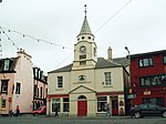 Upload another image | |||
| 10 Market Street | 54°54′21″N 5°01′44″W / 54.905742°N 5.028785°W / 54.905742; -5.028785 (10 Market Street) | Category C(S) | 41771 | Upload Photo | |||
| 31 Church Street | 54°54′14″N 5°01′40″W / 54.903935°N 5.027682°W / 54.903935; -5.027682 (31 Church Street) | Category B | 41749 | Upload Photo | |||
| 6 Academy Street Including Boundary Walls, Railings And Gate | 54°54′03″N 5°01′25″W / 54.900923°N 5.023712°W / 54.900923; -5.023712 (6 Academy Street Including Boundary Walls, Railings And Gate) | Category C(S) | 41756 | Upload Photo | |||
| Broadstone Road, Briarbrae Including Boundary Walls, Gatepiers, Gate And Garage | 54°54′46″N 5°02′30″W / 54.912737°N 5.041718°W / 54.912737; -5.041718 (Broadstone Road, Briarbrae Including Boundary Walls, Gatepiers, Gate And Garage) | Category C(S) | 45213 | Upload Photo | |||
| 40-44 (Even Nos) George Street | 54°54′17″N 5°01′40″W / 54.904681°N 5.027692°W / 54.904681; -5.027692 (40-44 (Even Nos) George Street) | Category C(S) | 45224 | Upload Photo | |||
| 8 Hanover Street | 54°54′12″N 5°01′21″W / 54.90332°N 5.022425°W / 54.90332; -5.022425 (8 Hanover Street) | Category C(S) | 45229 | Upload Photo | |||
| London Road, Stair Park Bandstand | 54°54′12″N 5°00′45″W / 54.903372°N 5.012381°W / 54.903372; -5.012381 (London Road, Stair Park Bandstand) | Category B | 45235 | Upload Photo | |||
| 17 North Strand Street | 54°54′18″N 5°01′34″W / 54.904989°N 5.02617°W / 54.904989; -5.02617 (17 North Strand Street) | Category B | 45239 | Upload Photo | |||
| 5 St John Street | 54°54′17″N 5°01′26″W / 54.904741°N 5.023858°W / 54.904741; -5.023858 (5 St John Street) | Category C(S) | 45240 | Upload Photo | |||
| 2-6 (Even Nos) George Street | 54°54′17″N 5°01′35″W / 54.904704°N 5.026398°W / 54.904704; -5.026398 (2-6 (Even Nos) George Street) | Category C(S) | 41767 | Upload Photo | |||
| Off Glebe Street, Park House | 54°54′15″N 5°02′07″W / 54.904194°N 5.0353°W / 54.904194; -5.0353 (Off Glebe Street, Park House) | Category B | 41775 | Upload Photo | |||
| 5 And 7 High Street | 54°54′17″N 5°01′50″W / 54.904628°N 5.030527°W / 54.904628; -5.030527 (5 And 7 High Street) | Category C(S) | 41779 | Upload Photo | |||
| Church Street, Dunbae House, Including Boundary Walls, Gatepiers And Railings | 54°54′14″N 5°01′42″W / 54.90379°N 5.028452°W / 54.90379; -5.028452 (Church Street, Dunbae House, Including Boundary Walls, Gatepiers And Railings) | Category B | 41747 | Upload Photo |
Key
The scheme for classifying buildings in Scotland is:
- Category A: "buildings of national or international importance, either architectural or historic; or fine, little-altered examples of some particular period, style or building type."[1]
- Category B: "buildings of regional or more than local importance; or major examples of some particular period, style or building type, which may have been altered."[1]
- Category C: "buildings of local importance; lesser examples of any period, style, or building type, as originally constructed or moderately altered; and simple traditional buildings which group well with other listed buildings."[1]
In March 2016 there were 47,288 listed buildings in Scotland. Of these, 8% were Category A, and 50% were Category B, with the remaining 42% being Category C.[2]
Notes
- ^ Sometimes known as OSGB36, the grid reference (where provided) is based on the British national grid reference system used by the Ordnance Survey.
• "Guide to National Grid". Ordnance Survey. Retrieved 12 December 2007.
• "Get-a-map". Ordnance Survey. Retrieved 17 December 2007. - ^ Historic Environment Scotland assign a unique alphanumeric identifier to each designated site in Scotland, for listed buildings this always begins with "LB", for example "LB12345".
References
- All entries, addresses and coordinates are based on data from Historic Scotland. This data falls under the Open Government Licence
- ^ a b c "What is Listing?". Historic Environment Scotland. Retrieved 29 May 2018.
- ^ Scotland's Historic Environment Audit 2016 (PDF). Historic Environment Scotland and the Built Environment Forum Scotland. pp. 15–16. Retrieved 29 May 2018.
- v
- t
- e
- Annan
- Applegarth
- Caerlaverock
- Canonbie
- Closeburn
- Cummertrees
- Dalton
- Dornock
- Dryfesdale
- Dumfries
- Dunscore
- Durisdeer
- Eskdalemuir
- Ewes
- Glencairn
- Gretna
- Half Morton
- Hoddom
- Holywood
- Hutton and Corrie
- Johnstone
- Keir
- Kirkconnel
- Kirkmahoe
- Kirkmichael
- Kirkpatrick-Fleming
- Kirkpatrick-Juxta
- Langholm
- Lochmaben
- Lockerbie
- Middlebie
- Moffat
- Morton
- Mouswald
- Penpont
- Ruthwell
- Sanquhar
- St Mungo
- Tinwald
- Torthorwald
- Tundergarth
- Tynron
- Wamphray
- Westerkirk
- Anwoth
- Balmaclellan
- Balmaghie
- Borgue
- Buittle
- Carsphairn
- Castle Douglas
- Colvend and Southwick
- Crossmichael
- Dalbeattie
- Dalry
- Gatehouse of Fleet
- Girthon
- Kells
- Kelton
- Kirkbean
- Kirkcudbright
- Kirkgunzeon
- Kirkmabreck
- Kirkpatrick Durham
- Kirkpatrick Irongray
- Lochrutton
- Minnigaff
- New Abbey
- New Galloway
- Newton Stewart
- Parton
- Rerrick
- Terregles
- Tongland
- Troqueer
- Twynholm
- Urr


