Lynch Historic District
Historic district in Kentucky, United States
United States historic place
Lynch Historic District | |
 | |
36°57′52″N 82°55′04″W / 36.96444°N 82.91778°W / 36.96444; -82.91778 | |
| Area | 125 acres (51 ha) |
|---|---|
| Architectural style | Colonial Revival, Bungalow/craftsman |
| NRHP reference No. | 03000086[1] |
| Added to NRHP | September 15, 2003 |
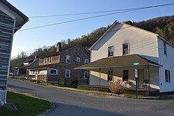
The Lynch Historic District, in Lynch, Kentucky, is a 125 acres (51 ha) historic district which was listed on the National Register of Historic Places in 2003. It included 298 contributing buildings, four contributing structures, and a contributing site.[1]
The district is roughly bounded by city limits, L&N railroad bed, Big Looney Cr., Second, Mountain, Highland Terrace, Liberty, and Church Streets.[1]
Lynch was the largest company-owned coal mining town in Kentucky and was established by U.S. Coal and Coke Company, a subsidiary of U.S. Steel.[2]
References
- ^ a b c "National Register Information System". National Register of Historic Places. National Park Service. July 9, 2010.
- ^ McKenzie Martin. "Lynch". ExploreKYHistory.
- v
- t
- e
- Architectural style categories
- Contributing property
- Historic district
- History of the National Register of Historic Places
- Keeper of the Register
- National Park Service
- Property types
- List of U.S. National Historic Landmarks by state:
- Alabama
- Alaska
- Arizona
- Arkansas
- California
- Colorado
- Connecticut
- Delaware
- Florida
- Georgia
- Hawaii
- Idaho
- Illinois
- Indiana
- Iowa
- Kansas
- Kentucky
- Louisiana
- Maine
- Maryland
- Massachusetts
- Michigan
- Minnesota
- Mississippi
- Missouri
- Montana
- Nebraska
- Nevada
- New Hampshire
- New Jersey
- New Mexico
- New York
- North Carolina
- North Dakota
- Ohio
- Oklahoma
- Oregon
- Pennsylvania
- Rhode Island
- South Carolina
- South Dakota
- Tennessee
- Texas
- Utah
- Vermont
- Virginia
- Washington
- West Virginia
- Wisconsin
- Wyoming
 National Register of Historic Places portal
 Category


This article about a property in Harlan County, Kentucky on the National Register of Historic Places is a stub. You can help Wikipedia by expanding it. |
- v
- t
- e


