Mékrou River
River in Benin, Burkina Faso and Niger

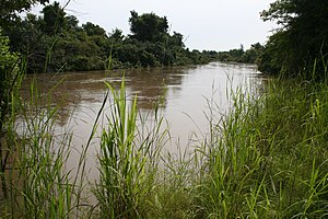
The Mékrou River is a river of Benin, Burkina Faso, and Niger. It flows through the W National Park.
A tributary of the Niger River, it begins in Benin north of Kouande and flows for 250 kilometers.[1] It forms part of the border between Benin and Burkina Faso and between Benin and Niger. The proposed construction of the Dyondyonga electricity dam on the river has caused concern among environmentalists[2].[citation needed]
Notes
References
- Houngnikpo, Mathurin; Decalo, Samuel (2013). Historical Dictionary of Benin. Rowman & Littlefield. ISBN 0810871718.
12°24′00″N 2°49′00″E / 12.4°N 2.81667°E / 12.4; 2.81667
- v
- t
- e
Niger River
- Guinea
- Mali
- Niger
- Benin
- Nigeria

- Source of the Niger
- Middle Niger
- Inner Niger Delta
- Lower Niger
- Niger Delta
distributaries
- Tinkisso River
- Sankarani River
- Milo River
- Bani River
- Mekrou River
- Alibori River
- Sokoto River
- Sota River
- Kaduna River
- Benue River
- Anambra River
- Forcados River
- Nun River
- Brass River
- King Fahd Bridge
- Martyrs Bridge
- Markala Dam
- Gao Bridge
- Kennedy Bridge
- Kainji Dam
- Jebba Dam
- River Niger Bridge (Onitsha)
Authority control databases | |
|---|---|
| International |
|
| National |
|
This article related to a river in Benin is a stub. You can help Wikipedia by expanding it. |
- v
- t
- e
This article related to a river in Burkina Faso is a stub. You can help Wikipedia by expanding it. |
- v
- t
- e
This article related to a river in Niger is a stub. You can help Wikipedia by expanding it. |
- v
- t
- e


