Maca District
District in Arequipa, Peru
Maca Maqa | |
|---|---|
District | |
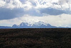 Hualca Hualca, Maca District | |
| Country |  Peru Peru |
| Region | Arequipa |
| Province | Caylloma |
| Capital | Maca |
| Government | |
| • Mayor | Hugo Eulogio Apaza Nina |
| Area | |
| • Total | 227.48 km2 (87.83 sq mi) |
| Elevation | 3,262 m (10,702 ft) |
| Population (2005 census) | |
| • Total | 1,307 |
| • Density | 5.7/km2 (15/sq mi) |
| Time zone | UTC-5 (PET) |
| UBIGEO | 040512 |
Maca District is one of twenty districts of the province Caylloma in Peru.[1]
-
 Colca River on the northern border of the Maca District
 -
 Souvenir sellers west of Maca
 -
 the church in Maca
 -
 The church in Maca (altar)


See also
- Colca River
- Hualca Hualca
References
- ^ (in Spanish) Instituto Nacional de Estadística e Informática. Banco de Información Distrital Archived 2008-04-23 at the Wayback Machine. Retrieved April 11, 2008.
- v
- t
- e

- Districts of Arequipa Region
- Peru

- Alto Selva Alegre
- Arequipa
- Cayma
- Cerro Colorado
- Characato
- Chiguata
- Jacobo Hunter
- José Luis Bustamante
- La Joya
- Mariano Melgar
- Miraflores
- Mollebaya
- Paucarpata
- Pocsi
- Polobaya
- Quequeña
- Sabandía
- Sachaca
- San Juan de Siguas
- San Juan de Tarucani
- Santa Isabel de Siguas
- Santa Rita de Siguas
- Socabaya
- Tiabaya
- Uchumayo
- Vitor
- Yanahuara
- Yarabamba
- Yura
15°38′33″S 71°46′12″W / 15.6425°S 71.7699°W / -15.6425; -71.7699
 | This Arequipa Region geography article is a stub. You can help Wikipedia by expanding it. |
- v
- t
- e


