Makarora River
River in Otago, New Zealand
44°04′53″S 169°27′34″E / 44.08138°S 169.45956°E / -44.08138; 169.45956 • location
• coordinates
• elevation
The Makarora River is in the Otago region of the South Island of New Zealand.
Name
The Kāi Tahu name for the river is Makarore. Manga (maka in the Kāi Tahu dialect) means stream. However the meaning of rore in this context is unknown.[1]
Geography
The headwaters are in Mount Aspiring National Park, on the eastern flanks of the Southern Alps near Haast Pass, which is the saddle between the Makarora and Haast River valleys. The Makarora River flows south into the northern end of Lake Wānaka after passing the small community of Makarora. The river attracts some recreational fishing, jetboating and kayaking. Rainbow and brown trout migrate from Lake Wānaka up the river and its tributaries to spawn, mainly in autumn and winter.[2]
Landslide
In September 2007 a landslide in the Young River valley blocked off the corresponding stream. Young River is a tributary to Makarora River. The landslide created a new lake which appears to be permanent.[citation needed]
Tourism
State Highway 6 follows the Makarora River for the majority of its course from just south of Haast Pass. A popular[3] short walk leads to its confluence with the Blue River, at the aptly named Blue Pools.[4] Cameron Flat Campground is a convenient campsite with a cooking shelter and bathrooms directly off State Highway 6.[citation needed]
Gallery
-
 Cameron Flat Campground
 -
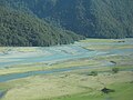 The Makarora River near West Makarora township
 -
 The Makarora River at Courtneys Flat


See also
References
- ^ "Makarore". Kā Huru Manu. Nga Rūnanga o Ngāi Tahu. Retrieved 22 October 2022.
- ^ Info panel at Blue Pools, Department of Conservation NZ
- ^ "101 Kiwi Must Do's: The Blue Pools of Haast Pass". NZ Automobile Association. Retrieved 22 March 2015.
- ^ "Blue Pools Track". Department of Conservation NZ. Retrieved 22 March 2015.
External links
Wikimedia Commons has media related to Makarora River.
- https://web.archive.org/web/20100105121020/http://www.geonet.org.nz/landslide/young-river-landslide/index.html
- https://web.archive.org/web/20100522172420/http://www.geonet.org.nz/docs/landslide/reports/Young-River-poster-A3.pdf
- v
- t
- e
Mount Aspiring National Park, New Zealand
- Mount Aspiring / Tititea
- Mount Brewster
- Mount Earnslaw
- Mount Franklin
- Humboldt Mountains
- Arawhata River
- Barrier River
- Bettne River
- Blue River
- Blue Duck River
- Bonar River
- Burke River
- Cascade River
- Dart River / Te Awa Whakatipu
- Donald River
- Drake River
- Fish River
- Forgotten River
- Haast River
- Joe River
- Kitchener River
- Makarora River
- Matukituki River
- Mueller River
- Ngatau River
- Okuru River
- Olivine River
- Pearson River
- Pyke River
- Red Pyke River
- Routeburn River
- Te Naihi River
- Turnbull River
- Waiatoto River
- Waipara River
- Whitbourn River
- Wilkin River
- Williamson River
- Wills River
- Young River
- Bridal Veil Falls
- Fantail Falls
- Roaring Billy Falls
- Thunder Creek Falls
- Haast-Hollyford road
- Lake Sylvan
- Pleasant Flat
This article about a river in the Otago region is a stub. You can help Wikipedia by expanding it. |
- v
- t
- e


