Manyana
Town in New South Wales, Australia
35°15′S 150°31′E / 35.250°S 150.517°E / -35.250; 150.517- 215 km (134 mi) S of Sydney
- 35 km (22 mi) N of Ulladulla
- 55 km (34 mi) S of Nowra
| Localities around Manyana: | ||
| Conjola | Bendalong | |
| Conjola | Manyana | Tasman Sea |
| Lake Conjola | Cunjurong Point | |
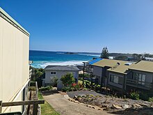
Manyana is a small town on the South Coast of New South Wales, Australia in the City of Shoalhaven.[2][3] At the 2016 census, it had a population of 521.[1] Manyana borders with Bendalong and Cunjurong Point.
Notes and references
- ^ a b Australian Bureau of Statistics (27 June 2017). "Manyana". 2016 Census QuickStats. Retrieved 25 January 2021.

- ^ a b c "Manyana". Geographical Names Register (GNR) of NSW. Geographical Names Board of New South Wales. Retrieved 25 January 2021.
- ^ "Manyana". OpenStreetMap. Retrieved 25 January 2021.
- v
- t
- e

- Nowra
- Bangalee
- Bomaderry
- Cambewarra
- Cambewarra Village
- Mundamia
- North Nowra
- Nowra Hill
- South Nowra
- Tapitallee
- Terara
- West Nowra
- Worrigee
- Back Forest
- Barrengarry
- Beaumont
- Bellawongarah
- Berry
- Berry Mountain
- Bolong
- Brogers Creek (part)
- Broughton
- Broughton Vale
- Broughton Village (part)
- Browns Mountain
- Budgong
- Bundewallah
- Coolangatta
- Far Meadow
- Illaroo
- Jaspers Brush
- Kangaroo Valley
- Meroo Meadow
- Shoalhaven Heads
- Upper Kangaroo River
- Watersleigh
- Wattamolla
- Woodhill
- Bamarang
- Barringella
- Beecroft Peninsula
- Bewong
- Brundee
- Burrier
- Comerong Island
- Coolumburra
- Culburra Beach
- Currarong
- Falls Creek
- Greenwell Point
- Jerrawangala
- Kinghorne
- Longreach
- Mayfield
- Numbaa
- Orient Point
- Parma
- Pyree
- Sassafras
- Tianjara
- Tolwong
- Tomerong
- Tullarwalla
- Wandandian
- Wollumboola
- Yalwal
- Yerriyong
- Ulladulla
- Croobyar
- Burrill Lake
- Dolphin Point
- Kings Point
- Little Forest
- Milton
- Mollymook
- Mollymook Beach
- Narrawallee
- Woodburn
- Woodstock
- Bawley Point
- Bendalong
- Berringer Lake
- Brooman
- Cockwhy
- Conjola
- Conjola Park
- Cunjurong Point
- Currowan (part)
- Depot Beach
- Durras North
- East Lynne
- Fishermans Paradise
- Kioloa
- Lake Conjola
- Manyana
- Mogood
- Mount Kingiman
- Pebbly Beach
- Pointer Mountain
- Pretty Beach
- Tabourie Lake
- Termeil
- Yatte Yattah
Main Article: Local government areas of New South Wales
 | This Shoalhaven geography article is a stub. You can help Wikipedia by expanding it. |
- v
- t
- e


