Mazā Jugla
River in Latvia
You can help expand this article with text translated from the corresponding article in Latvian. (December 2009) Click [show] for important translation instructions.
- View a machine-translated version of the Latvian article.
- Machine translation, like DeepL or Google Translate, is a useful starting point for translations, but translators must revise errors as necessary and confirm that the translation is accurate, rather than simply copy-pasting machine-translated text into the English Wikipedia.
- Do not translate text that appears unreliable or low-quality. If possible, verify the text with references provided in the foreign-language article.
- You must provide copyright attribution in the edit summary accompanying your translation by providing an interlanguage link to the source of your translation. A model attribution edit summary is
Content in this edit is translated from the existing Latvian Wikipedia article at [[:lv:Mazā Jugla]]; see its history for attribution. - You may also add the template
{{Translated|lv|Mazā Jugla}}to the talk page. - For more guidance, see Wikipedia:Translation.
| Mazā Jugla | |
|---|---|
 Mazā Jugla near Kranciems | |
 | |
| Location | |
| Country | Latvia |
| Physical characteristics | |
| Source | |
| • location | Taurupe parish, Ogre Municipality, Latvia |
| • elevation | 112 m (367 ft) |
| Mouth | Jugla |
• location | near Riga |
• coordinates | 56°58′10″N 24°19′24″E / 56.96944°N 24.32333°E / 56.96944; 24.32333 |
| Length | 119 km (74 mi) |
| Basin size | 675.3 km2 (260.7 sq mi) |
| Basin features | |
| Progression | Jugla→ Ķīšezers→ Mīlgrāvis→ Daugava→ Baltic Sea |
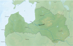
Mazā Jugla (previously German: Kleine Jägel) is a river in Latvia. It flows for 119 kilometres through the municipalities of Ogre, Salaspils, Ikšķile and Stopiņi. The source of the river is located in Taurupe parish, Ogre Municipality 130 m above sea level, whereas the mouth is 0.1 m asl.
Mazā Jugla joins with Lielā Jugla thus forming the river Jugla shortly before its mouth into Jugla Lake at the Riga city eastern border with the municipalities of Garkalne and Stopiņi. The river is curvy with many rapids and weirs, with dolomite and sandstone outcrops on its banks, and is a popular water tourism site. The Dobelnieki hydroelectric plant is located on the river.
The Battle of Jugla of World War I between the German and Russian armies took place on the banks of the river in 1917.
See also
| Authority control databases: National |
|
|---|
- v
- t
- e
This article related to a river in Latvia is a stub. You can help Wikipedia by expanding it. |
- v
- t
- e


