Mitata
Community in Greece
Mitata Μητάτα | |
|---|---|
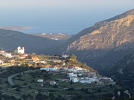 Mitata with Palaiopoli in the background | |
| 36°14′49″N 22°59′39″E / 36.24694°N 22.99417°E / 36.24694; 22.99417 | |
| Country | Greece |
| Administrative region | Attica |
| Regional unit | Islands |
| Municipality | Kythira |
| Municipal unit | Kythira |
| Elevation | 185 m (607 ft) |
| Population (2021)[1] | |
| • Community | 217 |
| Time zone | UTC+2 (EET) |
| • Summer (DST) | UTC+3 (EEST) |
| Postal code | 80100 |
| Area code(s) | +30 27360 |
Mitata is a small village and community in the middle of the island of Kythira, Greece. Its average elevation is 185 m.[2] Population 217 (2021).[1]
History
In 2006, an earthquake shattered Ayia Triadon making it no longer able to host church services. Mitata is on a cliff side looking over the neighbouring village of Viaradika. There is a cave underneath the Windmill resort called the "Mavri Spilaia" or "Black Cave".
Notable people
- George Miller[3]
References
- ^ a b "Αποτελέσματα Απογραφής Πληθυσμού - Κατοικιών 2021, Μόνιμος Πληθυσμός κατά οικισμό" [Results of the 2021 Population - Housing Census, Permanent population by settlement] (in Greek). Hellenic Statistical Authority. 29 March 2024.
- ^ "Population & housing census 2001 (incl. area and average elevation)" (PDF) (in Greek). National Statistical Service of Greece. Archived (PDF) from the original on 2015-09-21.
- ^ "Notable Kytherians - George Miller". www.kythera-family.net. Retrieved 2017-07-20.
- v
- t
- e
Subdivisions of the municipality of Kythira
- Aroniadika
- Kythira
- Fratsia
- Friligianika
- Karavas
- Karvounades
- Kontolianika
- Livadi
- Logothetianika
- Mitata
- Mylopotamos
- Myrtidia
- Potamos


