Mont Dolent
Mountain in the Mont Blanc massif


Mont Dolent
Location in the Alps
Valais, Switzerland
Haute-Savoie, France

Mont Dolent (3,823 metres (12,543 ft)) is a mountain in the Mont Blanc massif and lies on the border between Italy, Switzerland and France.
As a mountain, Mont Dolent is regarded as the tripoint between Italy, Switzerland and France, although the tripoint itself lies at 3,749 metres, less than 100 metres north-west of its summit.[2][3][4]
In 1954, a statue of the Virgin Mary was erected on Mont Dolent's summit by the young people of Valais.
Routes
The first ascent of the mountain was made on 9 July 1864 by A. Reilly and Edward Whymper with guides Michel Croz, H. Charlet and M. Payot. Whymper described the ascent in Scrambles amongst the Alps:
- We occupied the 9th with a scramble up Mont Dolent. This was a miniature ascent. It contained a little of everything. First we went up to the Petit Col Ferret, and had a little grind over shaly banks; then there was a little walk over grass; then a little tramp over a moraine (which, strange to say, gave a pleasant path); then a little zigzagging over the snow-covered glacier of Mont Dolent. Then there was a little bergschrund, then a little wall of snow [. . .] The summit itself was little, very small indeed; it was the loveliest little cone of snow that was ever piled up on a mountain-top; so soft, so pure; it seemed a crime to defile it; it was a miniature Jungfrau; a toy summit, you could cover it with a hand.[5]
Mont Dolent has four faces, offering good quality snow and ice climbs of various levels of difficulty. However the only straightforward route to the summit (graded PD) is on its southern flank via the Glacier de Pre de Bar, finishing along a short and exposed stretch of the south-east ridge. The Fiorio Bivouac Hut (also known as Refuge Bivouac du Dolent) provides the closest start point for this four-hour ascent from the Italian side.[6]: 131 The next easiest route of ascent (graded AD) is via the mountain's east ridge, starting from the similarly named Bivouac du Dolent (la Maye) hut on its Swiss side.[6]: 133
Huts
- Fiorio hut or Refuge Bivouac du Dolent – 2,724 m
- Bivouac du Dolent - la Maye – 2,667 m
- Cabane de l'A Neuve – 2,735 m
- Argentière Hut – 2,771 m
Gallery
-
 North side of Mont Dolent and Glacier d'Argentiere
 -
 Southern side of Mont Dolent from Refuge Bivouac du Dolent
 -
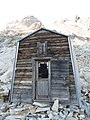 Refuge Bivouac du Dolent (Fiorio Refuge) on southern (Italian) side of the mountain
 -
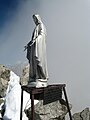 Mont Dolent summit statue, bearing inscription.
 -
 Mont Dolent from Val Ferret


See also
References
- ^ Retrieved from the Swisstopo and IGN topographic maps. The key col is Col du Dolent (3,490 m).
- ^ Portale Cartografico Nazionale Archived 2009-09-05 at the Wayback Machine
- ^ "Italy – Switzerland Boundary" (PDF). Florida State University. International Boundary Study. US. Department of State. 23 October 1961. Archived from the original (PDF) on 10 June 2016. Retrieved 22 August 2016.
- ^ Cartes IGN (Map). L'Institut national de l'information géographique et forestière. Retrieved 22 August 2016.
- ^ Edward Whymper, Scrambles amongst the Alps, 6th edition, London: John Murray, 1936, p. 195.
- ^ a b Griffin, Lindsay (1991). Mont Blanc Massif Volume 2. London: Alpine Club. ISBN 0900523581.
External links
- Mont Dolent on French IGN mapping portal
- Mont Dolent on SummitPost
- Mont Dolent on Hikr
- v
- t
- e


- Aiguille d'Argentière
- Aiguille de Bionnassay
- Aiguille de Blaitière
- Aiguille Blanche de Peuterey
- Aiguille du Chardonnet
- Aiguilles du Diable
- Aiguilles Dorées
- Aiguille du Dru
- Aiguille des Glaciers
- Aiguille du Goûter
- Aiguille des Grands Charmoz
- Aiguille des Grands Montets
- Aiguille du Grépon
- Aiguille du Jardin
- Aiguille du Midi
- Aiguille de l'A Neuve
- Aiguille Noire de Peuterey
- Aiguille du Pissoir
- Aiguille du Plan
- Aiguille de Rochefort
- Aiguille du Tour
- Aiguille de Tré la Tête
- Aiguille de Triolet
- Aiguille Verte
- La Breya
- Le Catogne
- Le Châtelet (Mont Blanc)
- Dent du Géant
- Dôme du Goûter
- Dôme de Rochefort
- Les Droites
- Le Génépi
- Grand Capucin
- Grand Darray
- Grand Pilier d'Angle
- Grande Lui
- Grande Pointe des Planereuses
- Grande Rocheuse
- Grandes Jorasses
- Mont Blanc
- Mont Blanc de Courmayeur
- Mont Blanc du Tacul
- Mont Brouillard
- Mont Dolent
- Mont Mallet
- Mont Maudit
- Pic Eccles
- Picco Luigi Amedeo
- Pointe Allobrogia
- Pointe Helbronner
- Pointe d'Orny
- Pointe des Plines
- Pointe Ronde
- Pointe Walker
- Le Portalet
- Punta Baretti
- Tita Neire
- Tour Noir
- Tour Ronde
(first or major ascents)
- Allain
- Almer
- Anderegg (J.)
- Anderegg (M.)
- Balmat
- Blanchard
- Blodig
- Boivin
- Bonatti
- Bonington
- Boulaz
- Bristow
- Brown
- Burgener
- Cassin
- Charlet
- Clough
- Cordier (H.)
- Cordier (P.)
- Couzy
- Croz
- Dent
- Desmaison
- Destivelle
- Długosz
- Eccles
- Eckenstein
- Gabarrou
- Ghirardini
- Graham Brown
- Güssfeldt
- Harlin
- Heckmair
- Hemming
- Hudson
- Kennedy
- King
- Klucker
- Kuffner
- Kukuczka
- Kurtyka
- Lachenal
- Lafaille
- Lambert
- MacIntyre
- Mallory
- Maund
- Mazeaud
- Messner
- Middlemore
- Moore
- Mummery
- Paccard
- Paradis
- Patey
- Ratti
- Rébuffat
- Rey
- Robbins
- Roch
- Rouse
- de Saussure
- Smythe
- Stephen
- Terray
- Twight
- Vallençant
- Walker
- Whillans
- Whymper
- Winthrop Young
- Arve (river)
- Chemin de fer du Montenvers
- Giardino Botanico Alpino Saussurea
- Haute Route
- Marathon du Mont Blanc
- Mont Blanc glacier flood
- Mont Blanc tramway
- Mont Blanc Tunnel
- Saint-Gervais–Vallorcine railway
- Skyway Monte Bianco
- Top of the Mont Blanc
- Tour du Mont Blanc
- Val d'Aosta
- Val Ferret
- Val Veny
- Vallée Blanche Aerial Tramway


