Mount Moran
Mountain in Wyoming, United States


Mount Moran
Grand Teton National Park, Teton County, Wyoming, U.S.
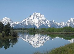
Mount Moran (12,610 feet (3,840 m)) is a mountain in Grand Teton National Park of western Wyoming, USA.[3] The mountain is named for Thomas Moran, an American western frontier landscape artist. Mount Moran dominates the northern section of the Teton Range rising 6,000 feet (1,800 m) above Jackson Lake.[4] Several active glaciers exist on the mountain with Skillet Glacier plainly visible on the monolithic east face. Like the Middle Teton in the same range, Mount Moran's face is marked by a distinctive basalt intrusion known as the Black Dike.
Climbing
Mount Moran is a massive and impressive mountain which would make it attractive to mountaineers. However, the comparative difficulty of the approach to the climbs makes it a much less popular climb than the Grand Teton and other peaks to the south. No trails to Mount Moran have been maintained for over twenty years, and any approach overland requires a great deal of bushwhacking through vegetation, deadfalls, and bogs along the perimeter of Leigh Lake. Instead, most climbers choose to canoe from String Lake, across Leigh Lake and then pick their way to their respective route; but even this may require some overland route finding. As a result, most climbs on Mount Moran tend to take several days even when the technical portion of the climb is comparatively brief.
The first ascent of Mount Moran was made on July 22, 1922 by LeGrand Hardy, Bennet McNulty, and Ben C. Rich of the Chicago Mountaineering Club, via the Skillet Glacier route. It still provides perhaps the easiest and most direct route to the summit, and is rated 5.4. As the name implies, most of the climb is on the steep snow and ice of Skillet Glacier, thus an ice axe and crampons are used during the ascent.
The most popular route up Mount Moran is the CMC route, named for the Chicago Mountaineering Club. The CMC is rated 5.5, and ascends the east face just south of the Black Dike. The CMC climbs good rock and is essentially free of snow and ice. It also has the advantage of a good camp high on the flank of the mountain.[5]
The Direct South Buttress, a grade IV claim rated from 5.7 A3 to 5.9 C1, is a technical route suited for aid and Alpine climbing. It has a vertical gain of approximately 1,500 feet (460 m), and features 11 pitches. This route is featured in the historic climbing text Fifty Classic Climbs of North America,[6] and was first ascended by Richard Emerson, Don Decker, and Leigh Ortenburger, August 30–31, 1953.
Climate
| Climate data for Mount Moran 43.8334 N, 110.7756 W, Elevation: 11,864 ft (3,616 m) (1991–2020 normals) | |||||||||||||
|---|---|---|---|---|---|---|---|---|---|---|---|---|---|
| Month | Jan | Feb | Mar | Apr | May | Jun | Jul | Aug | Sep | Oct | Nov | Dec | Year |
| Mean daily maximum °F (°C) | 19.4 (−7.0) | 18.6 (−7.4) | 23.4 (−4.8) | 28.4 (−2.0) | 38.0 (3.3) | 48.9 (9.4) | 59.3 (15.2) | 58.6 (14.8) | 49.5 (9.7) | 36.6 (2.6) | 24.7 (−4.1) | 18.7 (−7.4) | 35.3 (1.9) |
| Daily mean °F (°C) | 10.1 (−12.2) | 8.5 (−13.1) | 12.7 (−10.7) | 17.2 (−8.2) | 26.1 (−3.3) | 35.9 (2.2) | 45.1 (7.3) | 44.4 (6.9) | 36.2 (2.3) | 25.0 (−3.9) | 15.5 (−9.2) | 9.7 (−12.4) | 23.9 (−4.5) |
| Mean daily minimum °F (°C) | 0.8 (−17.3) | −1.7 (−18.7) | 2.0 (−16.7) | 5.9 (−14.5) | 14.5 (−9.7) | 23.0 (−5.0) | 30.8 (−0.7) | 30.2 (−1.0) | 22.8 (−5.1) | 13.4 (−10.3) | 6.3 (−14.3) | 0.7 (−17.4) | 12.4 (−10.9) |
| Average precipitation inches (mm) | 8.88 (226) | 7.27 (185) | 7.04 (179) | 6.40 (163) | 5.43 (138) | 3.94 (100) | 1.53 (39) | 1.66 (42) | 2.97 (75) | 4.73 (120) | 7.37 (187) | 8.78 (223) | 66 (1,677) |
| Source: PRISM Climate Group[7] | |||||||||||||
History
On November 21, 1950, a DC-3C cargo plane owned by the New Tribes Mission crashed on Mount Moran during a storm, killing all 21 on board. A rescue party organized by Paul Petzoldt located the wreckage on November 25, but the extreme location of the crash made it impossible to recover the plane or the bodies.[8] The wreckage remains on the mountain today, but the Park Service discourages climbs to the site.
-
 Mount Moran summit with Falling Ice Glacier at left and Skillet Glacier at right
 -
 Mount Moran with the Snake River in the foreground
 -
 Mount Moran rises abruptly above Jackson Lake. Grand Teton can be seen in the background at left


See also
References
- ^ a b "Mount Moran, Wyoming". Peakbagger.com. Retrieved 2011-05-28.
- ^ "Mount Moran". Geographic Names Information System. United States Geological Survey, United States Department of the Interior. Retrieved 2011-05-28.
- ^ Mount Moran, WY (Map). TopoQwest / United States Geological Survey. Retrieved May 28, 2011.
- ^ "Hayden Expedition". Wyoming Tales and Trails. Retrieved 10 October 2010.
- ^ Ortenburger, Leigh N.; Reynold G. Jackson (1996). A Climber's Guide to the Teton Range (3rd ed.). Mountaineers Books. ISBN 0-89886-480-1.
- ^ Roper, Steve; Steck, Allen (1979). Fifty Classic Climbs of North America. San Francisco: Sierra Club Books. pp. 165–170. ISBN 0-87156-292-8.
- ^ "PRISM Climate Group, Oregon State University". PRISM Climate Group, Oregon State University. Retrieved October 12, 2023.
To find the table data on the PRISM website, start by clicking Coordinates (under Location); copy Latitude and Longitude figures from top of table; click Zoom to location; click Precipitation, Minimum temp, Mean temp, Maximum temp; click 30-year normals, 1991-2020; click 800m; click Retrieve Time Series button.
- ^ "Rescuers Failed to Reach Downed New Tribes Plane". Christian History Institute. November 22, 1950. Archived from the original on April 4, 2005. Retrieved December 25, 2013.
External links
Wikimedia Commons has media related to Mount Moran.
- "Mount Moran" at Mountain Project
- "Mount Moran" at Summit Post
- Direct South Buttress" at Summit Post
- Mount Moran Photo Gallery of CMC route
- NASA Astronomy Photo of the Day - Great Fireball of August 10, 1972, over Mount Moran
- A climb of Mount Moran trip report with photos and video.
- v
- t
- e
- Abiathar Peak
- Atkins Peak
- Barronette Peak
- Breccia Peak
- Clayton Mountain
- Colter Peak
- Druid Peak
- Eagle Peak
- Fortress Mountain
- Francs Peak
- Index Peak
- Mount Chittenden
- First Peoples Mountain
- Mount Hornaday
- Mount Langford
- Mount Norris
- Mount Schurz
- Mount Stevenson
- Pilot Peak
- Sheep Mesa
- The Thunderer
- Washakie Needles
- Younts Peak
| Bear Lodge Mountains | |
|---|---|
| Others |
- Antler Peak
- Bannock Peak
- Bunsen Peak
- Clagett Butte
- Dome Mountain (Park County)
- Echo Peak
- Gray Peak
- Joseph Peak
- Mount Everts
- Mount Haynes
- Mount Holmes
- Mount Jackson
- Purple Mountain
- Quadrant Mountain
- Sepulcher Mountain
- Terrace Mountain
- Three Rivers Peak
- Trilobite Point
- White Peaks
- Darwin Peak
- Doubletop Peak
- Sheep Mountain
- Elk Mountain (Carbon County)
- Medicine Bow Peak
- Albright Peak
- Battleship Mountain
- Bivouac Peak
- Buck Mountain
- Cathedral Group
- Cleaver Peak
- Cloudveil Dome
- Disappointment Peak
- Doane Peak
- Dry Ridge Mountain
- Eagles Rest Peak
- Elk Mountain (Teton County)
- Forellen Peak
- Fossil Mountain
- Grand Teton
- Green Lakes Mountain
- Housetop Mountain
- The Jaw
- Littles Peak
- Maidenform Peak
- Middle Teton
- Moose Mountain
- Mount Bannon
- Mount Glory
- Mount Hunt
- Mount Jedediah Smith
- Mount Meek
- Mount Moran
- Mount Owen
- Mount Saint John
- Mount Wister
- Mount Woodring
- Mount Woodrow Wilson
- Nez Perce Peak
- Owl Peak
- Prospectors Mountain
- Rammell Mountain
- Ranger Peak
- Raynolds Peak
- Red Mountain
- Rendezvous Mountain
- Rendezvous Peak
- Rock of Ages
- Rockchuck Peak
- Rolling Thunder Mountain
- Shadow Peak
- South Teton
- Spearhead Peak
- Static Peak
- Survey Peak
- Symmetry Spire
- Table Mountain
- Teepe Pillar
- Teewinot Mountain
- Temple Peak
- Thor Peak
- Traverse Peak
- Veiled Peak
- The Wall
- Window Peak
- American Legion Peak
- Atlantic Peak
- Bair Peak
- Bastion Peak
- Bastion Peak-Northeast Peak
- Bears Ears Mountain
- Big Sandy Mountain
- Block Tower
- Bow Mountain
- Brown Cliffs North
- Cathedral Peak
- Desolation Peak
- Dog Tooth Peak
- Dome Mountain (Hot Springs County)
- Doublet Peak
- Downs Mountain
- East Temple Peak
- Flagstone Peak (Fremont County)
- Fremont Peak
- Gannett Peak
- Harrower Peak
- Henderson Peak
- Jackson Peak
- Klondike Peak
- Knife Point Mountain
- Lander Peak
- Lizard Head Peak
- Mitchell Peak
- Mount Bonneville
- Mount Chauvenet
- Mount Febbas
- Mount Helen
- Mount Hooker
- Mount Koven
- Mount Lander
- Mount Nystrom
- Mount Owen
- Mount Sacagawea
- Mount Warren
- Mount Washakie
- Mount Whitecap
- Overhanging Tower
- Payson Peak
- Pingora Peak
- Pylon Peak
- Raid Peak
- Rampart Peak
- Roaring Fork Mountain
- Roberts Mountain
- Shale Mountain
- Sharks Nose
- South Downs Mountain
- The Sphinx
- Split Mountain
- Sunbeam Peak
- Three Waters Mountain
- Torrey Peak
- Turret Peak
- Twin Peaks
- Union Peak
- Valentine Mountain
- Valentine Peak
- War Bonnet Peak
- Warrior Peaks
- Watch Tower
- Whiskey Mountain
- Wind River Peak
- Wolfs Head
- Amethyst Mountain
- Aspen Mountain
- Barlow Peak
- Bridger Mountains
- Cook Peak
- Copper Mountain
- Dirty Mountain
- Douglas Knob
- Dunraven Peak
- Factory Hill
- Ferris Mountains
- Folsom Peak
- Garfield Peak
- Granite Mountains
- Granite Peak
- Heart Mountain
- Hedges Peak
- Hoyt Peak
- Jelm Mountain
- Mansface Hill
- Mount Hancock
- Mount Leidy
- Mount Sheridan
- Mount Washburn
- National Park Mountain
- Owl Creek Mountains
- Prospect Peak (Park County)
- Rawhide Buttes
- Roaring Mountain
- Sierra Madre Range
- Signal Mountain
- Snake River Range
- Specimen Ridge
- Sublette Mountain
- Tongue Butte
- Trischman Knob
- White Mountain
- Wilkins Peak


