Mount Sirung
Volcano in East Nusa Tenggara, Indonesia
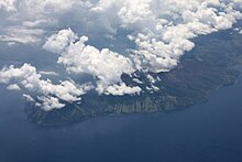
8°31′S 124°08′E / 8.517°S 124.133°E / -8.517; 124.133Mount Sirung (Indonesian: Gunung Sirung) is an active volcano complex volcano located on Pantar Island in the Alor archipelago of the eastern Indonesian province of Nusa Tenggara Timor. The crater rim can be reached by an easy hike from the village of Kakamauta. Inside the crater is a large sulphurous crater lake and several active steam vents. The last major eruption occurred 1970, and regular gas and clastic eruptions have occurred since 2004. A small eruption beginning May 12, 2012 triggered an evacuation of an area within a 1.5 km radius of the caldera.
See also
 Indonesia portal

References
- "Sirung". Global Volcanism Program. Smithsonian Institution.
External links
- Volcano Live
- Geology of Mt. Sirung (in Indonesian)
- Status Gunung Sirung Turun Jadi Waspada, Suara Mereka, 27 Mei 2012. (In Indonesian)
| Authority control databases: Geographic |
|
|---|


