Mukim Bukit Sawat
Mukim of Brunei
Mukim in Belait, Brunei
Mukim Bukit Sawat | |
|---|---|
Mukim | |
 Sungai Mau Recreational Park | |
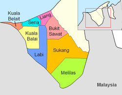 Bukit Sawat is in peach. | |
| Country | Brunei |
| District | Belait |
| Government | |
| • Penghulu | Salleh Othman[1] |
| Population (2021)[2] | |
| • Total | 759 |
| Time zone | UTC+8 (BNT) |
| Postcode | KFxx38 |
Mukim Bukit Sawat is a mukim in Belait District, Brunei.[3] It had a population of 794 in 2016.[4]
Geography
The mukim is located in the east of Belait District, bordering Mukim Telisai, Mukim Ukong and Mukim Rambai of Tutong District to the north, north-east and east respectively, Mukim Sukang to the south, Mukim Labi to the west and Mukim Liang to the north-west.[citation needed]
The mukim is named after Kampong Bukit Sawat, one of the villages it encompasses.
Demographics
As of the 2016 census,[4] the population was 794 with 57.1% males and 42.9% females. The mukim had 220 households occupying 220 dwellings. The entire population lived in rural areas.
Administration
As of 2021, the mukim comprised the following villages:
| Settlements[2] | Population (2021)[2] | Ketua kampung (2024)[1][5] |
|---|---|---|
| Sungai Mau | 407 | — |
| Bisut | 0 | |
| Bukit Sawat | 98 | Mohammad bin Abdullah @ Lim Swee Ann |
| Pulau Apil | 43 | — |
| Tarap | 11 | |
| Bukit Kandol | 1 | |
| Merangking | 24 | |
| Merangking Ulu | 80 | Raimey bin Abdullah |
| Merangking Hilir | 95 | |
| Melayan | 0 | — |
Facilities

Schools
The primary schools (sekolah rendah) in the mukim include:
- Merangking Primary School
- Orang Kaya Pemancha Berandai Primary School, Bukit Sawat — initially established as a Malay school and built in 1932.[6] A newer building was inaugurated on 28 August 1971 to replace the older building.[6]
Each school also houses a sekolah ugama (school for the country's Islamic religious primary education).
Mosques
- Al-Mashor Mosque, Kampong Sungai Mau — inaugurated by the then Prince Al-Muhtadee Billah on 28 February 1992; it can accommodate 200 worshippers.[7]
- Balai Ibadat Kampong Merangking
- Kampong Bukit Sawat Mosque — built in 1990 and can accommodate 120 worshippers.[8]
Tourism and recreation
- Sungai Mau Reacreation Park — a recreation park in Kampong Sungai Mau[9]
References
- ^ a b BUKU DIREKTORI TELEFON PENGHULU-PENGHULU MUKIM DAN KETUA-KETUA KAMPUNG NEGARA BRUNEI DARUSSALAM (PDF) (in Malay). Vol. 4. Brunei: Bahagian Perancangan Daerah, Ministry of Home Affairs. April 2024. p. 23.
- ^ a b c "Annex B" (PDF). DEPS.MoFE.gov.bn. Department of Economic Planning and Statistics, Ministry of Finance and Economy. October 2021. Retrieved 23 January 2024.
- ^ "Belait District" (PDF). www.information.gov.bn. 2011. pp. 8–9. Retrieved 28 June 2021.
- ^ a b "Population and Housing Census Update Final Report 2016" (PDF). www.deps.gov.bn. Statistics Department. December 2018. Retrieved 27 June 2021.
- ^ "Direktori Penghulu, Ketua Kampung, dan Ketua Rumah Panjang". Jabatan Daerah Belait (in Malay). Retrieved 20 August 2024.
- ^ a b "(Untitled)" (PDF). Pelita Brunei (in Malay). No. 16 #36. Jabatan Penyiaran dan Penerangan Kerajaan Brunei. 8 September 1971. p. 2. Retrieved 25 April 2022.
- ^ "SenaraiMasjid - Masjid Al-Mashor, Kampong Sungai Mau". www.kheu.gov.bn (in Malay). Retrieved 5 October 2021.
- ^ "SenaraiMasjid - Masjid Kampong Bukit Sawat". www.kheu.gov.bn (in Malay). Retrieved 5 October 2021.
- ^ "Sungai Mau Recreational Park - The Bruneian". Retrieved 9 July 2022.
- v
- t
- e
- Bukit Sawat
- Kuala Balai
- Kuala Belait
- Labi
- Liang
- Melilas
- Seria
- Sukang

4°27′09″N 114°24′04″E / 4.45250°N 114.40111°E / 4.45250; 114.40111
 | This Brunei location article is a stub. You can help Wikipedia by expanding it. |
- v
- t
- e


