National Register of Historic Places listings in Attala County, Mississippi

This is a list of the National Register of Historic Places listings in Attala County, Mississippi.
This is intended to be a complete list of the properties and districts on the National Register of Historic Places in Attala County, Mississippi, United States. Latitude and longitude coordinates are provided for many National Register properties and districts; these locations may be seen together in a map.[1]
There are 20 properties and districts listed on the National Register in the county.
This National Park Service list is complete through NPS recent listings posted September 5, 2024.[2]
Map all coordinates using OpenStreetMap
Download coordinates as:
- KML
- GPX (all coordinates)
- GPX (primary coordinates)
- GPX (secondary coordinates)
Current listings
| [3] | Name on the Register[4] | Image | Date listed[5] | Location | City or town | Description |
|---|---|---|---|---|---|---|
| 1 | Col. Chap Anderson House |  | February 26, 1987 (#87000233) | 402 N. Jackson St. 33°03′39″N 89°35′22″W / 33.0608°N 89.5894°W / 33.0608; -89.5894 (Col. Chap Anderson House) | Kosciusko | |
| 2 | Attala County Courthouse and Confederate Monument |  | November 17, 1997 (#97001299) | 230 W. Washington St. 33°03′30″N 89°35′24″W / 33.0583°N 89.59°W / 33.0583; -89.59 (Attala County Courthouse and Confederate Monument) | Kosciusko | |
| 3 | George Washington Brett House | Upload image | July 8, 2010 (#10000440) | 3021 Attala Rd. 3220 33°15′05″N 89°33′59″W / 33.2513°N 89.5663°W / 33.2513; -89.5663 (George Washington Brett House) | West vicinity | |
| 4 | David L. Brown House | 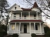 | December 2, 1977 (#77000784) | 200 E. Washington St. 33°03′32″N 89°35′18″W / 33.0589°N 89.5883°W / 33.0589; -89.5883 (David L. Brown House) | Kosciusko | |
| 5 | Col. J.K. Coffey House |  | February 8, 1979 (#79001306) | East of Sallis off Mississippi Highway 12 33°02′06″N 89°43′54″W / 33.035°N 89.7317°W / 33.035; -89.7317 (Col. J.K. Coffey House) | Sallis | |
| 6 | Hull L.V. Home and Studio | Upload image | June 17, 2024 (#100010441) | 123 Allen Street 33°03′04″N 89°35′10″W / 33.0510°N 89.5861°W / 33.0510; -89.5861 (Hull L.V. Home and Studio) | Kosciusko | |
| 7 | Jackson-Browne House | 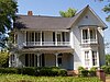 | February 5, 1987 (#87000038) | 107 N. Wells St. 33°03′25″N 89°35′36″W / 33.0569°N 89.5933°W / 33.0569; -89.5933 (Jackson-Browne House) | Kosciusko | |
| 8 | Jackson-Niles House | 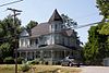 | September 27, 1984 (#84002127) | 121 N. Wells St. 33°03′32″N 89°35′37″W / 33.0589°N 89.5936°W / 33.0589; -89.5936 (Jackson-Niles House) | Kosciusko | |
| 9 | Johnson-Sullivant House | Upload image | June 26, 1986 (#86001385) | 709 S. Wells St. 33°03′21″N 89°35′35″W / 33.0558°N 89.5931°W / 33.0558; -89.5931 (Johnson-Sullivant House) | Kosciusko | |
| 10 | John Kimbrough Hall House | Upload image | March 5, 1998 (#98000184) | 5 miles north-northwest of Ethel 33°11′33″N 89°29′28″W / 33.1925°N 89.4911°W / 33.1925; -89.4911 (John Kimbrough Hall House) | Ethel | |
| 11 | Kosciusko Historic District | Upload image | March 31, 2009 (#08001084) | Roughly bounded by the Illinois, N. Wells, S. Natchez, Galloway, Bobo, S. Huntington, Jefferson St., and Highland Dr. 33°03′28″N 89°35′15″W / 33.0578°N 89.5875°W / 33.0578; -89.5875 (Kosciusko Historic District) | Kosciusko | |
| 12 | John Copeland Lucas House | Upload image | June 24, 1993 (#93000573) | 500 N. Huntington St. 33°03′43″N 89°35′13″W / 33.0619°N 89.5869°W / 33.0619; -89.5869 (John Copeland Lucas House) | Kosciusko | |
| 13 | Niles House | 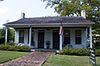 | March 11, 1998 (#98000186) | 401 N. Huntington St. 33°03′43″N 89°35′24″W / 33.0619°N 89.59°W / 33.0619; -89.59 (Niles House) | Kosciusko | |
| 14 | Judge Henry C. Niles House | 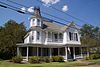 | May 6, 1993 (#93000383) | 305 N. Huntington St. 33°03′35″N 89°35′16″W / 33.0597°N 89.5878°W / 33.0597; -89.5878 (Judge Henry C. Niles House) | Kosciusko | |
| 15 | Old First Presbyterian Church | 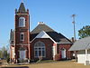 | July 10, 1992 (#92000846) | Junction of Huntington and Washington Sts. 33°03′31″N 89°35′15″W / 33.0586°N 89.5875°W / 33.0586; -89.5875 (Old First Presbyterian Church) | Kosciusko | |
| 16 | Old Natchez Trace (212-3K 213-3K) | Upload image | November 7, 1976 (#76000203) | Northeast of Kosciusko 33°12′46″N 89°27′11″W / 33.2128°N 89.4531°W / 33.2128; -89.4531 (Old Natchez Trace (212-3K 213-3K)) | Kosciusko | |
| 17 | Shrock House | Upload image | December 10, 1985 (#85003520) | Shrock Rd. 32°53′20″N 89°52′23″W / 32.8889°N 89.8731°W / 32.8889; -89.8731 (Shrock House) | Goodman | |
| 18 | Simmons Farmhouse | Upload image | May 13, 2021 (#100006554) | 9968 MS 429 33°00′44″N 89°45′51″W / 33.0122°N 89.7643°W / 33.0122; -89.7643 (Simmons Farmhouse) | Sallis vicinity | |
| 19 | Storer House | Upload image | July 25, 2003 (#03000688) | 300 N. Huntington St. 33°03′34″N 89°35′14″W / 33.0594°N 89.5872°W / 33.0594; -89.5872 (Storer House) | Kosciusko | |
| 20 | Thompson School | Upload image | June 24, 1994 (#94000647) | Ethel-McCool Rd., east of Ethel 33°06′58″N 89°22′40″W / 33.1161°N 89.3778°W / 33.1161; -89.3778 (Thompson School) | Ethel |
See also
Wikimedia Commons has media related to National Register of Historic Places in Attala County, Mississippi.
- List of National Historic Landmarks in Mississippi
- National Register of Historic Places listings in Mississippi
References
- ^ The latitude and longitude information provided in this table was derived originally from the National Register Information System, which has been found to be fairly accurate for about 99% of listings. Some locations in this table may have been corrected to current GPS standards.
- ^ National Park Service, United States Department of the Interior, "National Register of Historic Places: Weekly List Actions", retrieved September 5, 2024.
- ^ Numbers represent an alphabetical ordering by significant words. Various colorings, defined here, differentiate National Historic Landmarks and historic districts from other NRHP buildings, structures, sites or objects.
- ^ "National Register Information System". National Register of Historic Places. National Park Service. March 13, 2009.
- ^ The eight-digit number below each date is the number assigned to each location in the National Register Information System database, which can be viewed by clicking the number.
- v
- t
- e
by county
- Adams
- Alcorn
- Amite
- Attala
- Benton
- Bolivar
- Calhoun
- Carroll
- Chickasaw
- Choctaw
- Claiborne
- Clarke
- Clay
- Coahoma
- Copiah
- Covington
- DeSoto
- Forrest
- Franklin
- George
- Greene
- Grenada
- Hancock
- Harrison
- Hinds
- Holmes
- Humphreys
- Issaquena
- Itawamba
- Jackson
- Jasper
- Jefferson
- Jefferson Davis
- Jones
- Kemper
- Lafayette
- Lamar
- Lauderdale
- Lawrence
- Leake
- Lee
- Leflore
- Lincoln
- Lowndes
- Madison
- Marion
- Marshall
- Monroe
- Montgomery
- Neshoba
- Newton
- Noxubee
- Oktibbeha
- Panola
- Pearl River
- Perry
- Pike
- Pontotoc
- Prentiss
- Quitman
- Rankin
- Scott
- Sharkey
- Simpson
- Smith
- Stone
- Sunflower
- Tallahatchie
- Tate
- Tippah
- Tishomingo
- Tunica
- Union
- Walthall
- Warren
- Washington
- Wayne
- Webster
- Wilkinson
- Winston
- Yalobusha
- Yazoo

Municipalities and communities of Attala County, Mississippi, United States | ||
|---|---|---|
County seat: Kosciusko | ||
| Cities |  | |
| Towns | ||
| Unincorporated communities | ||
| Ghost towns | ||
| Indian reservation | ||
| Footnotes | ‡This populated place also has portions in an adjacent county or counties | |
| ||


