National Register of Historic Places listings in Ellis County, Kansas

This is a list of the National Register of Historic Places listings in Ellis County, Kansas.
This is intended to be a complete list of the properties and districts on the National Register of Historic Places in Ellis County, Kansas, United States. The locations of National Register properties and districts for which the latitude and longitude coordinates are included below, may be seen in a map.[1]
There are 20 properties and districts listed on the National Register in the county. Another 2 properties were once listed have been removed.
This National Park Service list is complete through NPS recent listings posted September 5, 2024.[2]
Map all coordinates using OpenStreetMap
Download coordinates as:
- KML
- GPX (all coordinates)
- GPX (primary coordinates)
- GPX (secondary coordinates)
Current listings
| [3] | Name on the Register[4] | Image | Date listed[5] | Location | City or town | Description |
|---|---|---|---|---|---|---|
| 1 | Justus Bissing Jr. Historic District |  | January 28, 2004 (#03001495) | 502-504 W. 12th St. 38°52′31″N 99°20′13″W / 38.8753°N 99.3369°W / 38.8753; -99.3369 (Justus Bissing Jr. Historic District) | Hays | Home built by craftsman Justus Bissing, Jr., and service station built for his son. |
| 2 | Brungardt-Dreiling Farmstead | Upload image | October 11, 2016 (#16000704) | 2567 Golf Course Rd. 38°51′24″N 99°08′20″W / 38.8568°N 99.1388°W / 38.8568; -99.1388 (Brungardt-Dreiling Farmstead) | Victoria | |
| 3 | Chestnut Street Historic District | 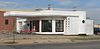 | July 9, 2008 (#06000621) | Main, W. 9th, W. 10th, W. 11th, E. 11th, and E. 12th Sts.; also 1302 Main St. 38°56′12″N 99°33′37″W / 38.9367°N 99.5603°W / 38.9367; -99.5603 (Chestnut Street Historic District) | Hays | 1302 Main represents a boundary increase of May 24, 2011; a second boundary increase was approved July 25, 2022. |
| 4 | Walter P. Chrysler House |  | February 23, 1972 (#72000495) | 104 W. 10th St. 38°56′11″N 99°33′39″W / 38.9365°N 99.5609°W / 38.9365; -99.5609 (Walter P. Chrysler House) | Ellis | |
| 5 | Drees House |  | March 2, 2001 (#01000183) | 100 E. 19th St. 38°52′42″N 99°19′34″W / 38.8782°N 99.3260°W / 38.8782; -99.3260 (Drees House) | Hays | |
| 6 | Ellis Congregational Church |  | March 9, 2000 (#00000156) | Eighth and Washington Sts. 38°56′26″N 99°33′38″W / 38.9405°N 99.5606°W / 38.9405; -99.5606 (Ellis Congregational Church) | Ellis | |
| 7 | First Presbyterian Church | Upload image | March 30, 1973 (#73000753) | 100 W. 7th St. 38°52′15″N 99°19′50″W / 38.8708°N 99.3306°W / 38.8708; -99.3306 (First Presbyterian Church) | Hays | |
| 8 | Fort Fletcher Stone Arch Bridge | 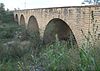 | May 18, 2001 (#01000385) | 4.8 miles (7.7 km) south of Walker, Walker Ave. 38°47′53″N 99°04′39″W / 38.7981°N 99.0775°W / 38.7981; -99.0775 (Fort Fletcher Stone Arch Bridge) | Walker | |
| 9 | Fort Hays |  | January 25, 1971 (#71000314) | Frontier Historical Park 38°51′46″N 99°20′06″W / 38.8628°N 99.335°W / 38.8628; -99.335 (Fort Hays) | Hays | |
| 10 | Gallagher House |  | March 2, 2001 (#01000184) | 310 E. 20th St. 38°52′39″N 99°19′17″W / 38.8774°N 99.3215°W / 38.8774; -99.3215 (Gallagher House) | Hays | |
| 11 | George Grant Villa |  | April 26, 1972 (#72000496) | 2680 Grants Villa Road[6] 38°46′05″N 99°07′11″W / 38.7681°N 99.1196°W / 38.7681; -99.1196 (George Grant Villa) | Victoria | |
| 12 | Memorial City Hall | 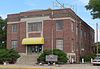 | March 15, 2007 (#07000142) | 911 Washington St. 38°56′18″N 99°33′36″W / 38.9384°N 99.5599°W / 38.9384; -99.5599 (Memorial City Hall) | Ellis | |
| 13 | Merchants Bank of Ellis |  | May 2, 2002 (#02000428) | 822 Washington St. 38°56′20″N 99°33′38″W / 38.9390°N 99.5605°W / 38.9390; -99.5605 (Merchants Bank of Ellis) | Ellis | |
| 14 | J.A. Mermis House | 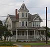 | April 8, 2009 (#09000190) | 1401 Ash Street 38°52′34″N 99°19′56″W / 38.8760°N 99.3322°W / 38.8760; -99.3322 (J.A. Mermis House) | Hays | |
| 15 | Papes Barn |  | October 5, 2015 (#15000689) | 890 Ellis Ave. 38°48′39″N 99°33′25″W / 38.8108°N 99.5570°W / 38.8108; -99.5570 (Papes Barn) | Ellis | |
| 16 | Pawnee Tipi Ring Site and Golden Spring Beach | Upload image | July 2, 2018 (#100002307) | Address Restricted | Hays | |
| 17 | Phillip Hardware Store |  | March 16, 1982 (#82002658) | 719 Main St. 38°52′14″N 99°19′54″W / 38.8705°N 99.3317°W / 38.8705; -99.3317 (Phillip Hardware Store) | Hays | |
| 18 | St. Fidelis Catholic Church |  | May 14, 1971 (#71000315) | Southeastern corner of St. Anthony and Delaware Sts. 38°51′24″N 99°09′01″W / 38.8567°N 99.1503°W / 38.8567; -99.1503 (St. Fidelis Catholic Church) | Victoria | |
| 19 | St. Joseph's Church and Parochial School | 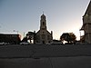 | November 19, 2008 (#08001066) | 210 and 217 W. 13th St. 38°51′24″N 99°09′01″W / 38.8567°N 99.1503°W / 38.8567; -99.1503 (St. Joseph's Church and Parochial School) | Hays | |
| 20 | Washington Grade School | Upload image | April 1, 2021 (#100006323) | 305 Main St. 38°52′01″N 99°20′03″W / 38.8669°N 99.3341°W / 38.8669; -99.3341 (Washington Grade School) | Hays |
Former listings
| [3] | Name on the Register | Image | Date listed | Date removed | Location | City or town | Description |
|---|---|---|---|---|---|---|---|
| 1 | Krueger Building | Upload image | March 8, 2006 (#06000111) | January 2, 2013 | 811 Fort St. 38°52′13″N 99°20′01″W / 38.870278°N 99.333611°W / 38.870278; -99.333611 (Krueger Building) | Hays | Demolished in 2012. |
| 2 | Madden Elevator | Upload image | June 29, 1982 (#82002657) | January 2, 1985 | 117 E. 9th St. | Hays | Demolished in October, 1984. |
See also
Wikimedia Commons has media related to National Register of Historic Places in Ellis County, Kansas.
- List of National Historic Landmarks in Kansas
- National Register of Historic Places listings in Kansas
References
- ^ The latitude and longitude information provided in this table was derived originally from the National Register Information System, which has been found to be fairly accurate for about 99% of listings. Some locations in this table may have been corrected to current GPS standards.
- ^ National Park Service, United States Department of the Interior, "National Register of Historic Places: Weekly List Actions", retrieved September 5, 2024.
- ^ a b Numbers represent an alphabetical ordering by significant words. Various colorings, defined here, differentiate National Historic Landmarks and historic districts from other NRHP buildings, structures, sites or objects.
- ^ "National Register Information System". National Register of Historic Places. National Park Service. March 13, 2009.
- ^ The eight-digit number below each date is the number assigned to each location in the National Register Information System database, which can be viewed by clicking the number.
- ^ "George Grant Villa". Rural Kansas Tourism. Retrieved 2014-09-25.
- v
- t
- e

- Allen
- Anderson
- Atchison
- Barber
- Barton
- Bourbon
- Brown
- Butler
- Chase
- Chautauqua
- Cherokee
- Cheyenne
- Clark
- Clay
- Cloud
- Coffey
- Comanche
- Cowley
- Crawford
- Decatur
- Dickinson
- Doniphan
- Douglas
- Edwards
- Elk
- Ellis
- Ellsworth
- Finney
- Ford
- Franklin
- Geary
- Gove
- Graham
- Grant
- Gray
- Greeley
- Greenwood
- Hamilton
- Harper
- Harvey
- Haskell
- Hodgeman
- Jackson
- Jefferson
- Jewell
- Johnson
- Kearny
- Kingman
- Kiowa
- Labette
- Lane
- Leavenworth
- Lincoln
- Linn
- Logan
- Lyon
- Marion
- McPherson
- Meade
- Miami
- Mitchell
- Montgomery
- Morris
- Morton
- Nemaha
- Neosho
- Ness
- Norton
- Osage
- Osborne
- Ottawa
- Pawnee
- Phillips
- Pottawatomie
- Pratt
- Rawlins
- Reno
- Republic
- Rice
- Riley
- Rooks
- Rush
- Russell
- Saline
- Scott
- Sedgwick
- Seward
- Shawnee
- Sheridan
- Sherman
- Smith
- Stafford
- Stanton
- Stevens
- Sumner
- Thomas
- Trego
- Wabaunsee
- Wallace
- Washington
- Wichita
- Wilson
- Woodson
- Wyandotte
- Archaeological sites
- National Historic Landmarks
 Category
 NRHP portal


Municipalities and communities of Ellis County, Kansas, United States | ||
|---|---|---|
County seat: Hays | ||
| Cities |  | |
| CDPs | ||
| Unincorporated communities | ||
| Ghost towns | ||
| Townships | ||
| ||


