National Register of Historic Places listings in Floyd County, Iowa

This is a list of the National Register of Historic Places listings in Floyd County, Iowa.
This is intended to be a complete list of the properties and districts on the National Register of Historic Places in Floyd County, Iowa, United States. Latitude and longitude coordinates are provided for many National Register properties and districts; these locations may be seen together in a map.[1]
There are 20 properties and districts listed on the National Register in the county.
This National Park Service list is complete through NPS recent listings posted August 23, 2024.[2]
Map all coordinates using OpenStreetMap
Download coordinates as:
- KML
- GPX (all coordinates)
- GPX (primary coordinates)
- GPX (secondary coordinates)
Current listings
| [3] | Name on the Register[4] | Image | Date listed[5] | Location | City or town | Description |
|---|---|---|---|---|---|---|
| 1 | Brooks Round Barn | Upload image | June 30, 1986 (#86001429) | West of U.S. Route 218 42°57′00″N 92°35′04″W / 42.95°N 92.584444°W / 42.95; -92.584444 (Brooks Round Barn) | Nashua | No longer exists. |
| 2 | Central Park-North Main Street Historic District |  | August 10, 1976 (#76000771) | N. Main St. and N. Jackson St. 43°04′06″N 92°40′43″W / 43.068333°N 92.678611°W / 43.068333; -92.678611 (Central Park-North Main Street Historic District) | Charles City | |
| 3 | Charles City Junior-Senior High School | Upload image | September 5, 2017 (#100001567) | 500 N. Grand Ave. 43°04′05″N 92°40′20″W / 43.067933°N 92.672092°W / 43.067933; -92.672092 (Charles City Junior-Senior High School) | Charles City | |
| 4 | Cook Farm | Upload image | June 18, 1979 (#79000895) | South of Charles City on U.S. Route 218 43°01′51″N 92°38′41″W / 43.030833°N 92.644722°W / 43.030833; -92.644722 (Cook Farm) | Charles City | |
| 5 | A.B.C. Dodd House | 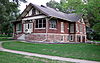 | May 22, 1978 (#78001220) | 310 3rd Ave. 43°03′55″N 92°40′06″W / 43.065278°N 92.668333°W / 43.065278; -92.668333 (A.B.C. Dodd House) | Charles City | |
| 6 | Dr. Salsbury's Laboratories, Main Office and Production Laboratory Building | 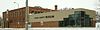 | March 7, 1996 (#96000235) | 500 Gilbert St. 43°03′47″N 92°40′44″W / 43.063056°N 92.678889°W / 43.063056; -92.678889 (Dr. Salsbury's Laboratories, Main Office and Production Laboratory Building) | Charles City | |
| 7 | Floyd County Court House |  | August 28, 2003 (#03000816) | 101 S. Main St. 43°03′56″N 92°40′54″W / 43.065556°N 92.681667°W / 43.065556; -92.681667 (Floyd County Court House) | Charles City | |
| 8 | Charles Walter Hart House |  | January 25, 1980 (#80001450) | 800 3rd Ave. 43°03′55″N 92°39′38″W / 43.065278°N 92.660556°W / 43.065278; -92.660556 (Charles Walter Hart House) | Charles City | |
| 9 | Hawkeye Street Underpass |  | June 25, 1998 (#98000777) | South Hawkeye St. under the railroad line 43°08′14″N 93°00′34″W / 43.137222°N 93.009306°W / 43.137222; -93.009306 (Hawkeye Street Underpass) | Nora Springs | |
| 10 | Lucius and Maria Clinton Lane House | 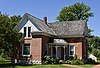 | April 24, 1995 (#95000384) | 2379 Timber Ave. 43°00′45″N 92°39′15″W / 43.0125°N 92.654167°W / 43.0125; -92.654167 (Lucius and Maria Clinton Lane House) | Charles City | |
| 11 | Main Street Bridge |  | March 12, 1999 (#99000311) | Main St. over the Cedar River 43°03′58″N 92°40′48″W / 43.066111°N 92.68°W / 43.066111; -92.68 (Main Street Bridge) | Charles City | |
| 12 | Marble Rock Bank | Upload image | November 10, 1982 (#82000407) | 313 Bradford St. 42°57′55″N 92°52′04″W / 42.965278°N 92.867778°W / 42.965278; -92.867778 (Marble Rock Bank) | Marble Rock | |
| 13 | Alvin Miller House |  | November 16, 1978 (#78001221) | 1107 Court St. 43°04′05″N 92°41′04″W / 43.068056°N 92.684444°W / 43.068056; -92.684444 (Alvin Miller House) | Charles City | |
| 14 | Charles Henry Parr House |  | January 24, 1980 (#80001451) | 100 W. Hulin St. 43°04′23″N 92°40′56″W / 43.073056°N 92.682222°W / 43.073056; -92.682222 (Charles Henry Parr House) | Charles City | |
| 15 | River Street Bridge | Upload image | June 25, 1998 (#98000778) | River St. over a drainage ditch 42°58′00″N 92°52′10″W / 42.966667°N 92.869306°W / 42.966667; -92.869306 (River Street Bridge) | Marble Rock | |
| 16 | Rockford Mill | Upload image | July 28, 1983 (#83000358) | Shell Rock River at 4th and Main St. 43°03′02″N 92°56′31″W / 43.050556°N 92.941944°W / 43.050556; -92.941944 (Rockford Mill) | Rockford | |
| 17 | Sherman Nursery Company Historic District |  | November 12, 2014 (#14000905) | 1300 Grove st. 43°03′54″N 92°41′21″W / 43.065°N 92.689167°W / 43.065; -92.689167 (Sherman Nursery Company Historic District) | Charles City | |
| 18 | Spotts Round Barn | Upload image | June 30, 1986 (#86001430) | Iowa Highway 14 43°03′33″N 92°43′29″W / 43.059056°N 92.724694°W / 43.059056; -92.724694 (Spotts Round Barn) | Charles City | |
| 19 | Tyden Farm No. 6 Farmstead Historic District | Upload image | June 11, 2009 (#09000401) | 1145 300th St. 42°55′23″N 92°59′48″W / 42.923056°N 92.996667°W / 42.923056; -92.996667 (Tyden Farm No. 6 Farmstead Historic District) | Dougherty | |
| 20 | Wildwood Park Historic District |  | September 25, 1998 (#98001205) | 1 Wildwood Rd. 43°03′46″N 92°41′37″W / 43.062778°N 92.693611°W / 43.062778; -92.693611 (Wildwood Park Historic District) | Charles City |
Former listings
One listing in Floyd county has been removed from the Register:
| [3] | Name on the Register | Image | Date listed | Date removed | Location | City or town | Description |
|---|---|---|---|---|---|---|---|
| 1 | Suspension Bridge | Upload image | October 30, 1989 (#89001778) | January 8, 2009 | Over the Big Cedar River at end of Clark St. | Charles City | Destroyed by a flood. |
See also
Wikimedia Commons has media related to National Register of Historic Places in Floyd County, Iowa.
- List of National Historic Landmarks in Iowa
- National Register of Historic Places listings in Iowa
- Listings in neighboring counties: Bremer, Butler, Cerro Gordo, Chickasaw, Franklin, Howard, Mitchell
References
- ^ The latitude and longitude information provided in this table was derived originally from the National Register Information System, which has been found to be fairly accurate for about 99% of listings. Some locations in this table may have been corrected to current GPS standards.
- ^ National Park Service, United States Department of the Interior, "National Register of Historic Places: Weekly List Actions", retrieved August 23, 2024.
- ^ a b Numbers represent an alphabetical ordering by significant words. Various colorings, defined here, differentiate National Historic Landmarks and historic districts from other NRHP buildings, structures, sites or objects.
- ^ "National Register Information System". National Register of Historic Places. National Park Service. April 24, 2008.
- ^ The eight-digit number below each date is the number assigned to each location in the National Register Information System database, which can be viewed by clicking the number.
- v
- t
- e
- List of U.S. National Historic Landmarks by state:
- Alabama
- Alaska
- Arizona
- Arkansas
- California
- Colorado
- Connecticut
- Delaware
- Florida
- Georgia
- Hawaii
- Idaho
- Illinois
- Indiana
- Iowa
- Kansas
- Kentucky
- Louisiana
- Maine
- Maryland
- Massachusetts
- Michigan
- Minnesota
- Mississippi
- Missouri
- Montana
- Nebraska
- Nevada
- New Hampshire
- New Jersey
- New Mexico
- New York
- North Carolina
- North Dakota
- Ohio
- Oklahoma
- Oregon
- Pennsylvania
- Rhode Island
- South Carolina
- South Dakota
- Tennessee
- Texas
- Utah
- Vermont
- Virginia
- Washington
- West Virginia
- Wisconsin
- Wyoming
 National Register of Historic Places portal
 Category


