National Register of Historic Places listings in Joshua Tree National Park
This is a list of the National Register of Historic Places listings in Joshua Tree National Park.
This is intended to be a complete list of the properties and districts on the National Register of Historic Places in Joshua Tree National Park, California, United States. The locations of National Register properties and districts for which the latitude and longitude coordinates are included below, may be seen in an online map.
There are six properties and districts listed on the National Register in the park.
This National Park Service list is complete through NPS recent listings posted August 16, 2024.[1]
Map all coordinates using OpenStreetMap
Download coordinates as:
- KML
- GPX (all coordinates)
- GPX (primary coordinates)
- GPX (secondary coordinates)
Current listings
| [2] | Name on the Register | Image | Date listed[3] | Location | City or town | Description |
|---|---|---|---|---|---|---|
| 1 | Barker Dam | 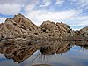 | October 29, 1975 (#75000173) | SE of Twentynine Palms in Joshua Tree National Park 34°01′51″N 116°08′47″W / 34.03092°N 116.146363°W / 34.03092; -116.146363 (Barker Dam) | Twentynine Palms vicinity | |
| 2 | Cow Camp | 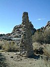 | October 29, 1975 (#75000228) | SW of Twentynine Palms in Joshua Tree National Park 34°02′12″N 116°09′48″W / 34.03671°N 116.163415°W / 34.03671; -116.163415 (Cow Camp) | Twentynine Palms vicinity | |
| 3 | Desert Queen Mine | 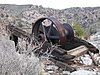 | January 17, 1976 (#76000216) | S of Twentynine Palms in Joshua Tree National Park 34°01′27″N 116°04′17″W / 34.024112°N 116.071372°W / 34.024112; -116.071372 (Desert Queen Mine) | Twentynine Palms vicinity | |
| 4 | Keys Desert Queen Ranch | 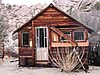 | October 30, 1975 (#75000174) | SW of Twentynine Palms in Joshua Tree National Park 34°02′44″N 116°10′09″W / 34.045684°N 116.169266°W / 34.045684; -116.169266 (Keys Desert Queen Ranch) | Twentynine Palms vicinity | |
| 5 | Ryan House and Lost Horse Well | 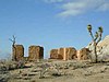 | June 5, 1975 (#75000175) | S of Twentynine Palms in Joshua Tree National Park 33°59′04″N 116°08′57″W / 33.984419°N 116.149238°W / 33.984419; -116.149238 (Ryan House and Lost Horse Well) | Twentynine Palms vicinity | |
| 6 | Wall Street Mill |  | November 12, 1975 (#75000176) | S of Twentynine Palms in Joshua Tree National Park 34°02′11″N 116°08′02″W / 34.036517°N 116.134003°W / 34.036517; -116.134003 (Wall Street Mill) | Twentynine Palms vicinity |
See also
- National Register of Historic Places listings in Riverside County, California
- National Register of Historic Places listings in San Bernardino County, California
- National Register of Historic Places listings in San Diego County, California
- List of National Historic Landmarks in California
- National Register of Historic Places listings in California
References
- ^ National Park Service, United States Department of the Interior, "National Register of Historic Places: Weekly List Actions", retrieved August 16, 2024.
- ^ Numbers represent an alphabetical ordering by significant words. Various colorings, defined here, differentiate National Historic Landmarks and historic districts from other NRHP buildings, structures, sites or objects.
- ^ The eight-digit number below each date is the number assigned to each location in the National Register Information System database, which can be viewed by clicking the number.
External links
Wikimedia Commons has media related to National Register of Historic Places in Joshua Tree National Park.
- v
- t
- e
- Barker Dam
- Wall Street Mill
See also: National Register of Historic Places listings in Joshua Tree National Park
| |
|---|---|
| Topics | |
| Lists by state |
|
| Lists by insular areas | |
| Lists by associated state | |
| Other areas | |
| Related | |
| |


