National Register of Historic Places listings in Lassen Volcanic National Park
This is a list of the National Register of Historic Places listings in Lassen Volcanic National Park.
This is intended to be a complete list of the properties and districts on the National Register of Historic Places in Lassen Volcanic National Park, California, United States. The locations of National Register properties and districts for which the latitude and longitude coordinates are included below, may be seen in a Google map.[1]
There are 13 properties and districts listed on the National Register in the park.
This National Park Service list is complete through NPS recent listings posted August 16, 2024.[2]
Map all coordinates using OpenStreetMap
Download coordinates as:
- KML
- GPX (all coordinates)
- GPX (primary coordinates)
- GPX (secondary coordinates)
Current listings
| [3] | Name on the Register | Image | Date listed[4] | Location | City or town | Description |
|---|---|---|---|---|---|---|
| 1 | Drakesbad Guest Ranch |  | October 22, 2003 (#03001062) | Head of Warner Creek Valley, Lassen Volcanic National Park 40°26′23″N 121°24′52″W / 40.439722°N 121.414444°W / 40.439722; -121.414444 (Drakesbad Guest Ranch) | Chester | A resort outside of Chester, operating since the early 1900s on former ranch land. |
| 2 | Horseshoe Lake Ranger Station |  | May 5, 1978 (#78000292) | N of Chester in Lassen Volcanic National Park 40°28′23″N 121°19′48″W / 40.473056°N 121.33°W / 40.473056; -121.33 (Horseshoe Lake Ranger Station) | Chester | A ranger station built by the CCC in 1934. It is the only standard-plan station in the Lassen backcountry. |
| 3 | Lassen Volcanic National Park Highway Historic District |  | June 23, 2006 (#06000527) | NPS Route 1, CA 89 40°30′02″N 121°30′38″W / 40.500556°N 121.510556°W / 40.500556; -121.510556 (Lassen Volcanic National Park Highway Historic District) | Mineral | The main roadway of Lassen Volcanic, intentionally designed to provide for scenic tourism in the park. |
| 4 | Loomis Visitor Center, Bldg. 43 | 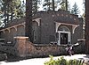 | February 25, 1975 (#75000177) | Lassen Volcanic National Park 40°32′10″N 121°33′44″W / 40.536111°N 121.562222°W / 40.536111; -121.562222 (Loomis Visitor Center, Bldg. 43) | Manzanita Lake | Park property built in 1927 by Benjamin Loomis, now used as a museum. |
| 5 | Manzanita Lake Naturalist's Services Historic District |  | June 23, 2006 (#06000525) | 39489 CA 44 40°32′08″N 121°33′51″W / 40.535556°N 121.564167°W / 40.535556; -121.564167 (Manzanita Lake Naturalist's Services Historic District) | Shingletown | A visitor services building at the northwest entrance of the park. |
| 6 | Mount Harkness Fire Lookout |  | June 19, 2017 (#100001211) | 40°18′40″N 121°18′06″W / 40.31111°N 121.30166°W / 40.31111; -121.30166 (Mount Harkness Fire Lookout) | Mineral | Fire lookout on Mount Harkness built in 1931. |
| 7 | Nobles Emigrant Trail |  | October 3, 1975 (#75000222) | E of Shingletown in Lassen Volcanic National Park 40°32′50″N 121°25′29″W / 40.547222°N 121.424722°W / 40.547222; -121.424722 (Nobles Emigrant Trail) | Shingletown | A portion of a historic wagon trail through the Lassen region, now designated as a hiking trail. |
| 8 | Park Headquarters, Lassen Volcanic National Park | 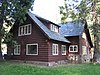 | October 3, 1978 (#06000490) | Off CA 36 40°20′45″N 121°36′27″W / 40.345833°N 121.6075°W / 40.345833; -121.6075 (Park Headquarters, Lassen Volcanic National Park) | Mineral | The headquarters of the park and formerly the visitor center. Built in 1928. |
| 9 | Prospect Peak Fire Lookout | Upload image | March 30, 1978 (#78000295) | 40°34′24″N 121°20′42″W / 40.57333°N 121.345°W / 40.57333; -121.345 (Prospect Peak Fire Lookout) | Mineral | A fire lookout built in 1912, making it one of the oldest used by the U.S. Forest Service |
| 10 | Sulphur Creek Archeological District | Upload image | April 14, 1980 (#80000370) | Coordinates missing | Mill Creek | |
| 11 | Summit Lake Ranger Station |  | April 3, 1978 (#78000296) | NE of Mineral in Lassen Volcanic National Park 40°29′54″N 121°25′37″W / 40.498333°N 121.426944°W / 40.498333; -121.426944 (Summit Lake Ranger Station) | Mineral | A small wooden cabin built in 1926 along the main road. |
| 12 | Twin Lakes Fire Tool Cache | Upload image | October 25, 2016 (#16000745) | 40°30′46″N 121°21′47″W / 40.512720°N 121.363067°W / 40.512720; -121.363067 (Twin Lakes Fire Tool Cache) | Mineral vicinity | A small backcountry cabin built in 1935 to hold firefighting equipment. |
| 13 | Warner Valley Ranger Station |  | April 3, 1978 (#78000364) | N of Chester in Lassen Volcanic National Park 40°26′28″N 121°22′57″W / 40.441111°N 121.3825°W / 40.441111; -121.3825 (Warner Valley Ranger Station) | Chester | A wooden cabin built in 1926, the first in the newly-incorporated park. |
See also
- National Register of Historic Places listings in Lassen County, California
- National Register of Historic Places listings in Plumas County, California
- National Register of Historic Places listings in Shasta County, California
- National Register of Historic Places listings in Tehama County, California
- National Register of Historic Places listings in California
References
- Emmons, Ann; Catton, Ted. National Register of Historic Places Multiple Property Documentation Form: Lassen Volcanic National Park Multiple Property Listing. National Park Service February 2004 https://npgallery.nps.gov/NRHP/GetAsset/NRHP/64500949_text
- ^ The latitude and longitude information provided in this table was derived originally from the National Register Information System, which has been found to be fairly accurate for about 99% of listings. Some locations in this table may have been corrected to current GPS standards.
- ^ National Park Service, United States Department of the Interior, "National Register of Historic Places: Weekly List Actions", retrieved August 16, 2024.
- ^ Numbers represent an alphabetical ordering by significant words. Various colorings, defined here, differentiate National Historic Landmarks and historic districts from other NRHP buildings, structures, sites or objects.
- ^ The eight-digit number below each date is the number assigned to each location in the National Register Information System database, which can be viewed by clicking the number.
- v
- t
- e
See also: National Register of Historic Places listings in Lassen Volcanic National Park
| |
|---|---|
| Topics | |
| Lists by state |
|
| Lists by insular areas | |
| Lists by associated state | |
| Other areas | |
| Related | |
| |


Wikimedia Commons has media related to National Register of Historic Places in Lassen Volcanic National Park.


