National Register of Historic Places listings in St. John the Baptist Parish, Louisiana

This is a list of the National Register of Historic Places listings in St. John the Baptist Parish, Louisiana.
This is intended to be a complete list of the properties and districts on the National Register of Historic Places in St. John the Baptist Parish, Louisiana, United States. The locations of National Register properties and districts for which the latitude and longitude coordinates are included below, may be seen in a map.[1]
There are 18 properties and districts listed on the National Register in the parish, including 2 National Historic Landmarks.
This National Park Service list is complete through NPS recent listings posted August 23, 2024.[2]
Map all coordinates using OpenStreetMap
Download coordinates as:
- KML
- GPX (all coordinates)
- GPX (primary coordinates)
- GPX (secondary coordinates)
Current listings
| [3] | Name on the Register[4] | Image | Date listed[5] | Location | City or town | Description |
|---|---|---|---|---|---|---|
| 1 | Bacas House |  | May 17, 1990 (#90000786) | Louisiana Highway 18 east of Evergreen Plantation 30°01′25″N 90°37′37″W / 30.023611°N 90.626944°W / 30.023611; -90.626944 (Bacas House) | Edgard | |
| 2 | Bayou Jasmine Archeological Site | Upload image | July 12, 1976 (#76002149) | Address Restricted | LaPlace | |
| 3 | E.J. Caire & Co. Store |  | November 29, 2001 (#01001268) | 2403-2407 Louisiana Highway 18 30°02′45″N 90°33′36″W / 30.045833°N 90.56°W / 30.045833; -90.56 (E.J. Caire & Co. Store) | Edgard | Store begun by Jean Baptiste Caire (1823-1879) and operated for years by the late Etienne J. Caire, who died in 1955; it closed in the middle 1970s. |
| 4 | Dugas House |  | August 31, 1989 (#89001211) | Louisiana Highway 18 30°02′10″N 90°36′09″W / 30.036111°N 90.6025°W / 30.036111; -90.6025 (Dugas House) | Edgard | |
| 5 | Emilie Plantation House |  | January 13, 1989 (#88003135) | Louisiana Highway 44 30°02′45″N 90°36′34″W / 30.045833°N 90.609444°W / 30.045833; -90.609444 (Emilie Plantation House) | Garyville | |
| 6 | Evergreen Plantation |  | September 25, 1991 (#91001386) | Louisiana Highway 18 southeast of Fiftymile Pt. 30°01′06″N 90°38′50″W / 30.018333°N 90.647222°W / 30.018333; -90.647222 (Evergreen Plantation) | Wallace | Composed of 37 buildings, including a main house and 22 extant slave cabins, Evergreen Plantation is an intact example of major plantation complexes found during the antebellum era of the Southern United States.[6] Open to visitors. |
| 7 | Garyville Historic District | 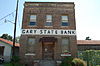 | April 20, 1990 (#89001711) | Roughly bounded by Main, Bluebird, West, Azalea, Cypress, St. Francis, and N. Railroad Sts. 30°03′24″N 90°37′09″W / 30.056667°N 90.619167°W / 30.056667; -90.619167 (Garyville Historic District) | Garyville | |
| 8 | Godchaux-Reserve Plantation House | 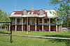 | January 21, 1994 (#93001548) | 1628 Louisiana Highway 44 30°03′19″N 90°33′50″W / 30.055278°N 90.563889°W / 30.055278; -90.563889 (Godchaux-Reserve Plantation House) | Reserve | |
| 9 | Graugnard House |  | October 28, 1994 (#94001249) | 2292 Louisiana Highway 44 30°03′18″N 90°35′21″W / 30.055°N 90.589167°W / 30.055; -90.589167 (Graugnard House) | Reserve | |
| 10 | Haydel-Jones House |  | November 3, 2010 (#10000886) | 2245 Louisiana Highway 18 (River Rd.) 30°02′46″N 90°34′02″W / 30.046111°N 90.567222°W / 30.046111; -90.567222 (Haydel-Jones House) | Edgard | Louisiana's French Creole Architecture MPS |
| 11 | Hope Plantation House |  | January 11, 2005 (#04001470) | 109 S. Church St. 30°02′25″N 90°37′03″W / 30.040278°N 90.6175°W / 30.040278; -90.6175 (Hope Plantation House) | Garyville | |
| 12 | Montegut Plantation House |  | January 21, 1988 (#87002505) | 402 E. 5th St. 30°03′31″N 90°28′51″W / 30.058611°N 90.480833°W / 30.058611; -90.480833 (Montegut Plantation House) | LaPlace | |
| 13 | Our Lady of Grace Church |  | November 15, 2005 (#05001277) | Near the junction of Airline Highway and 3rd St. 30°04′23″N 90°33′23″W / 30.073056°N 90.556389°W / 30.073056; -90.556389 (Our Lady of Grace Church) | Reserve | |
| 14 | San Francisco Plantation House | 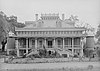 | May 30, 1974 (#74002186) | 3 miles west of Reserve on Louisiana Highway 44 30°02′57″N 90°36′20″W / 30.049167°N 90.605556°W / 30.049167; -90.605556 (San Francisco Plantation House) | Reserve | |
| 15 | Sorapuru House |  | August 20, 1999 (#99001014) | 971 Louisiana Highway 18 30°02′47″N 90°29′53″W / 30.046389°N 90.498056°W / 30.046389; -90.498056 (Sorapuru House) | Edgard | |
| 16 | Southern Pacific Steam Locomotive #745 |  | September 4, 1998 (#98001077) | Timbermill Museum 29°58′01″N 90°08′37″W / 29.967°N 90.14374°W / 29.967; -90.14374 (Southern Pacific Steam Locomotive #745) | Garyville | Restored 1921 Louisiana built steam locomotive; moved from Jefferson c. 2023. |
| 17 | Whitney Plantation Historic District |  | November 24, 1992 (#92001566) | Louisiana Highway 18 east of Wallace 30°02′21″N 90°39′02″W / 30.039167°N 90.650556°W / 30.039167; -90.650556 (Whitney Plantation Historic District) | Wallace | |
| 18 | Woodland Plantation |  | October 4, 2017 (#100001712) | 1128 Louisiana Highway 628 30°03′41″N 90°28′56″W / 30.061519°N 90.482124°W / 30.061519; -90.482124 (Woodland Plantation) | LaPlace |
See also
Wikimedia Commons has media related to National Register of Historic Places in Saint John the Baptist Parish, Louisiana.
- List of National Historic Landmarks in Louisiana
- National Register of Historic Places listings in Louisiana
References
- ^ The latitude and longitude information provided in this table was derived originally from the National Register Information System, which has been found to be fairly accurate for about 99% of listings. Some locations in this table may have been corrected to current GPS standards.
- ^ National Park Service, United States Department of the Interior, "National Register of Historic Places: Weekly List Actions", retrieved August 23, 2024.
- ^ Numbers represent an alphabetical ordering by significant words. Various colorings, defined here, differentiate National Historic Landmarks and historic districts from other NRHP buildings, structures, sites or objects.
- ^ "National Register Information System". National Register of Historic Places. National Park Service. March 13, 2009.
- ^ The eight-digit number below each date is the number assigned to each location in the National Register Information System database, which can be viewed by clicking the number.
- ^ "Evergreen Plantation". National Register of Historic Places Travel Itinerary. National Park Service. Retrieved 2015-11-14.
- v
- t
- e
- List of U.S. National Historic Landmarks by state:
- Alabama
- Alaska
- Arizona
- Arkansas
- California
- Colorado
- Connecticut
- Delaware
- Florida
- Georgia
- Hawaii
- Idaho
- Illinois
- Indiana
- Iowa
- Kansas
- Kentucky
- Louisiana
- Maine
- Maryland
- Massachusetts
- Michigan
- Minnesota
- Mississippi
- Missouri
- Montana
- Nebraska
- Nevada
- New Hampshire
- New Jersey
- New Mexico
- New York
- North Carolina
- North Dakota
- Ohio
- Oklahoma
- Oregon
- Pennsylvania
- Rhode Island
- South Carolina
- South Dakota
- Tennessee
- Texas
- Utah
- Vermont
- Virginia
- Washington
- West Virginia
- Wisconsin
- Wyoming
 National Register of Historic Places portal
 Category


Municipalities and communities of St. John the Baptist Parish, Louisiana, United States | ||
|---|---|---|
Parish seat: Edgard | ||
| CDPs |  | |
| Other communities | ||
| Ghost town | ||
| Footnotes | ‡This populated place also has portions in an adjacent parish | |
| ||


